Nevejski preval - Rifugio Gilberti (via 636)
Starting point: Nevejski preval (1170 m)
| Latitude/Longitude: | 46,3874°N 13,4734°E |
| |
Route name: via 636
Walking time: 2 h 15 min
Difficulty: easy marked way
Elevation gain: 680 m
Elevation difference along the route: 680 m
Map: Julijske Alpe - zahodni del 1:50.000
Recommended equipment (summer):
Recommended equipment (winter): ice axe, crampons
Views: 9.326
 | 2 people like this post |
Access to starting point:
A) First, we drive to Kranjska Gora, and then we continue driving through the border crossing Rateče into Italy. We drive towards Trbiž / Tarvisio, and then at the beginning of the mentioned town, we turn left in the direction of Bovec. Further, we drive on a regional road towards the border crossing Predel, and we follow the main road to a crossroad near Rabeljsko jezero / Lago del Predil. Here we continue right in the direction of Nevejski preval (V Žlebeh) / Sella Nevea and on an asphalt road, we reach the already mentioned saddle. We park on a large parking lot by the lower station of the circular cabin cable car, which runs towards the mountain hut Rifugio Gilberti.
B) First, we drive to Bovec, and then we continue driving towards the border crossing Predel, through which we drive into Italy. Next follows a descent to Rabeljsko jezero, after which we leave the main road which leads towards Trbiž and we continue driving left in the direction of Nevejski preval (V Žlebeh). The road then again starts ascending, and we follow it to the already mentioned saddle. We park on a large parking lot by the lower station of the circular cabin cable car, which runs towards the mountain hut Rifugio Gilberti.
Route description:
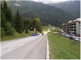
From the parking lot, we go on a narrow asphalt road which leads us by the hotel Nevea. After approximately 100 meters of walking, we get to a signpost for path number 636, which points us left through a meadow on a marked footpath. The path soon leads into the forest, through which we are further ascending on an old military mule track. Higher the forest is becoming thinner, and the path with more frequent nice views brings us to the ruins of barracks Poviz.
The path ahead continues ascending for some time, and then it brings us to a marked junction, where we continue right in the direction of the mountain hut Rifugio Gilberti (left saddle Prevala, saddle Vrh Laških brežičev / Sella Robon, Speleological bivak and Velika Bavha). From the junction onwards, the path entirely flattens and continues towards the west. We cross panoramic slopes for approximately 20 minutes, and then the path brings us to the ski runs of the Sella Nevea ski area. At the same time as we step on the ski area, we also step on the transport-rescue road, which we then follow past the chapel to the mountain hut Rifugio Gilberti, which we reach after a few minutes of additional walking.

Photos:
 1
1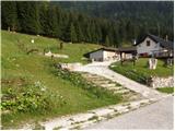 2
2 3
3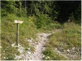 4
4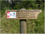 5
5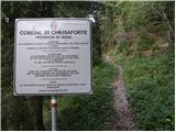 6
6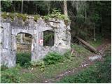 7
7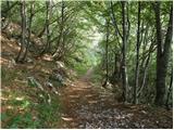 8
8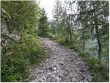 9
9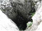 10
10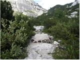 11
11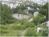 12
12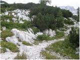 13
13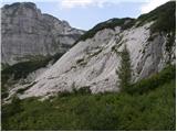 14
14 15
15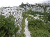 16
16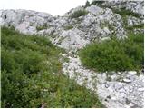 17
17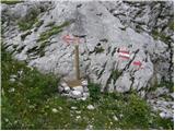 18
18 19
19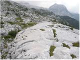 20
20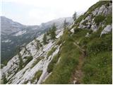 21
21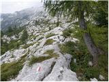 22
22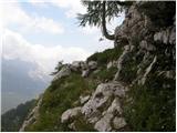 23
23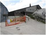 24
24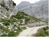 25
25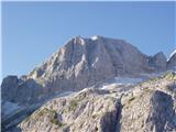 26
26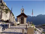 27
27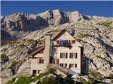 28
28
Discussion about the trip Nevejski preval - Rifugio Gilberti (via 636)
|
| matej71231. 08. 2015 |
We walked it on Sunday - path 636 and 636a. Magnificent views, real wilderness. However, the entire crossing took us much more than 20 min - about 1.5 hours. Similar timing is here too - http://www.sentiericai-fvg.it/636a.htm
The path is well marked, but not much frequented, so you have to navigate from mark to mark.
Maybe someone knows what those kind of 'chimneys' sticking obliquely out of the rocks are for? We noticed at least four.
|
|
|
|
| BT8831. 08. 2015 |
I think for artificial avalanche triggering. We mean the same ones
|
|
|
|
| stef27. 09. 2015 |
I walked this trail today and I must say that the time estimate for this trail is quite misleading. matej712 described quite well how much time it takes to hike trail 636A. I would just add that this trail doesn't really level out at all but constantly climbs and descends, albeit not steeply, and moreover you have to be constantly very careful where you step, as there are lots of holes and sharp rocks on the trail
|
|
|
|
| rokeg9. 09. 2022 20:24:58 |
This path is not exactly easy. At two places you really need to use your hands. There are two short jumps. In addition, you go over a rocky little bridge between two blackthorns. If the path from Reklanska dolina to Gorjuda is demanding, this path is too. The crossing also takes at least 1 hour.
|
|
|
|
| djimuzl10. 09. 2022 10:54:41 |
Maybe Rok and Tadej followed Igor's "timetable" - he, given his knowledge of these areas, has walked many paths a bit more "under an hour"... 
|
|
|
|
| Silvia callin20. 08. 2025 11:53:19 |
Good day, the description of this trail is really misleading. According to CAI data, it takes 3:30 h to complete this trail, not 2:15 h as written above. From the intersection, picture no. 18, you write 20 min of easy trail, CAI marks 1:15 h. The trail is not easy, it is demanding, especially not for families with children or dogs. This was once a "shortcut" for speleologists, which CAI "appropriated" and marked. It would be good to correct the above text so that no more accidents happen on this section of the trail. Safe steps to all....
|
|
|
To post a comment you must log in:
If you do not yet have a username, you must first
register.