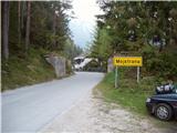
Starting point: Mojstrana (675 m)
| Latitude/Longitude: | 46,4552°N 13,9321°E |
| |
Walking time: 4 h 15 min
Difficulty: easy marked way
Elevation gain: 1402 m
Elevation difference along the route: 1402 m
Map: TNP 1:50.000
Recommended equipment (summer):
Recommended equipment (winter): ice axe, crampons
Views: 108.113
 | 12 people like this post |
Access to starting point:
We leave the Gorenjska motorway at the Hrušica exit and follow the road ahead in the direction of Kranjska Gora. Just a little before the village of Dovje, the road to Mojstrana (Vrata, Kot and Krma) branches off to the left from the main road. We follow the road ahead in the direction of the Vrata valley and drive along it only for a short time, as we will soon spot the mountain signposts for Vrtaška planina by the road. We park at the parking lot by the road, which is located a few meters ahead.
Route description:
From the parking lot, we descend the road a few meters downhill, where a signpost directs us to a wide footpath. The path initially ascends moderately and brings us to a junction in a few minutes, where we continue straight ahead (right leads the path to the vantage point Grančišče).
The path soon after crosses a shorter muddy section of the path, then turns left and ascends ever more steeply thereafter. The path ahead is steep and runs through the forest. After an hour and a half of walking, the steepness eases, and the path transitions to scree slopes. This is followed by crossing a wide artificial ledge protected by a fence (the fence is for protecting livestock), from which a nice view opens onto the surrounding peaks. The path then returns to the forest for a while and ascends steeply again. Slightly higher up, the steepness eases, we cross a grazing fence, and in a few more minutes of walking we step onto Vrtaška planina, where on the right side we spot a shepherd's hut equipped with an emergency bivouac in the attic of the house.
The path ahead ascends across a meadow and then turns sharply left into the forest. The path through the forest ascends moderately and after 20 minutes of walking from the pasture brings us to a larger clearing, which we merely cross. The path then returns to the forest, which becomes progressively thinner. The path, now relatively gentle, brings us after a while to a nice vantage point from which a beautiful view opens up.
This is followed by a short descent and then some traverses with a slight ascent to a large grassy slope below Vrtaški vrh, where an unmarked path from the Peričnik waterfall joins us.
The path then turns slightly right and continues gently ascending across the meadow. Slightly higher, the path transitions from the grassy slopes into a belt of dwarf pines and begins to ascend more steeply. From the moderately steep path, surrounded by a belt of sparse larch forest, a view opens towards Sleme (2077 m). The otherwise marked path begins to fade gradually, but in fine weather orientation is not difficult. The path then ascends steeply again and brings us to the ridge, where ahead of us we spot Špik and Kukova špica. We continue left (right to Drobeče Sleme) and follow the panoramic ridge path, which after 10 minutes of further walking brings us to the panoramic summit.
Mojstrana - Vrtaška planina 2:00, Vrtaška planina - Sleme 2:15.

Photos:
 1
1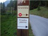 2
2 3
3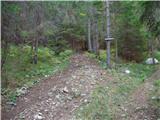 4
4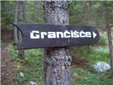 5
5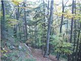 6
6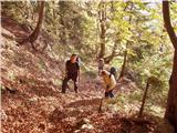 7
7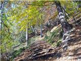 8
8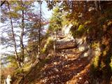 9
9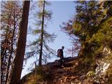 10
10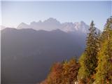 11
11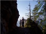 12
12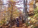 13
13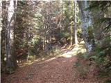 14
14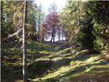 15
15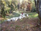 16
16 17
17 18
18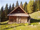 19
19 20
20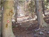 21
21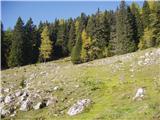 22
22 23
23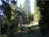 24
24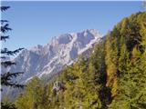 25
25 26
26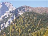 27
27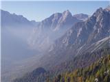 28
28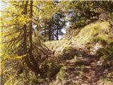 29
29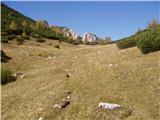 30
30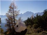 31
31 32
32 33
33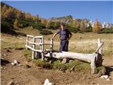 34
34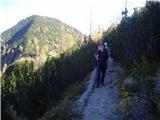 35
35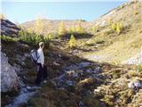 36
36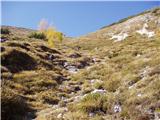 37
37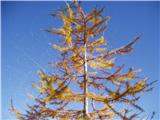 38
38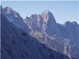 39
39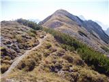 40
40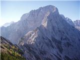 41
41 42
42
Discussion about the trip Mojstrana - Sleme
Show older messages
|
| andrejjerina3. 08. 2009 |
Today the view through the window didn't promise a high alpine visit, so I opted for one of the nearer and quicker ascents. "Steep is the path to heaven, very steep..." I whistled this ditty climbing towards Vrtaška planina. Nice and pleasant path, but very steep to Vrtaška planina! From it onwards the path is very pleasant, just careful on descent not to veer towards Čerlovec. Best, Andrej
|
|
|
|
| Kriška3. 08. 2009 |
Hm, for me 2077 m already counts as high mountains. And 4.5 hours hiking one way would be quite a good "bite" for me   . .
|
|
|
|
| viharnik3. 08. 2009 |
According to old guidebooks, altitudes over 1500m are already considered high mountains. Even above this altitude, it can snow at any time of the year. Nice tour you did before the deterioration.
|
|
|
|
| grahelj24. 05. 2010 |
Has anyone walked this path recently? Is the path dry yet?
|
|
|
|
| knap422724. 05. 2010 |
Up to the fields it's dry, further on there's still quite a bit of snow that occasionally breaks through. The path to Vrtaški vrh is dry, climb up to it (10 min), from it you also have a nice view of the continuing path towards Sleme and so you can assess the conditions yourself.
|
|
|
|
| ruševec5. 07. 2010 |
On Saturday we headed to Sleme along the marked trail. Leon, we actually took 4.30 hours, it's true that we looked at practically every flowering plant, the entire view, photographed everything, in short, slow tourist walking. The descent took us 3 hours. I do not recommend the trail to people with little fitness and those for whom sour milk or beer in a hut makes sense. Because on this trail you can't get anything. You're dependent on what's in your backpack.
|
|
|
|
| hribuc858. 07. 2010 |
Yesterday I was at Sleme. I think the marked time is somewhat exaggerated. I do have younger legs, I walked the path in 2.5 hours including several short beer stops and a somewhat longer chat with the shepherd below Vrtaška planina. If walking moderately, there's no way it takes more than 3 hours. No offense to flower lovers. There really are plenty, I looked at them on the way back.
Regarding the path: yes, go directly from the parking as described. The path is distinct, trees are marked (not with blazes). And much enjoyment to all with easy slopes and beauties of high alpine pastures.
Good luck.
|
|
|
|
| EUGEN8. 07. 2010 |
Why is walking time important?
Hiking in the mountains is no competition, but enjoyment and facing nature and oneself.
That's my opinion, everyone has their own pleasures.
l.p.
|
|
|
|
| hribuc858. 07. 2010 |
EUGEN, you're absolutely right. But if you're dependent on timetables (train, bus, ...) it's good to know the appropriate marked times so you can plan your tour.
|
|
|
|
| klavdipo19. 09. 2010 |
Is there a stamp on this summit besides the logbook?
|
|
|
|
| chackk28. 10. 2010 |
How is the path right now? Approximately how many cm of snow is there right now, if someone can tell me?
|
|
|
|
| dj1211. 11. 2010 |
Has anyone been to Sleme these days after the snowfall? Is there quite a lot of snow? LP
|
|
|
|
| alesh7411. 11. 2010 |
There is more than half a meter of snow...
|
|
|
|
| karlin26. 01. 2011 |
Has anyone been to Sleme recently, what are the conditions, how much snow is there?
Thanks!
|
|
|
|
| kr neki9. 05. 2011 |
How much snow is left on this path?
Thanks.
|
|
|
|
| ZZ10. 05. 2011 |
I was on Sleme about a month ago, and there was some snow only above approx. 1800 m
|
|
|
|
| JORDAN23. 05. 2011 |
On Saturday 21.5.2011 we walked this path, there is some snow from 1800 m onwards. The path is really quite steep and at the beginning you grind your knees for a good 1.5 hours. I can hardly believe that they drive cows up this path, let alone back down to the valley.
|
|
|
|
| mošt25. 08. 2011 |
Yesterday I was at the top. Really, where do the cows come up here? Yesterday they weren't seen or cowbells heard. There's drought on the pasture, the watering place at Njivice is dried up. Obviously they had to go to the valley, but on the path I took there were no cow tracks. The day was wonderful, but at the top it was unbearable. I experienced an invasion of flying ants that annoyingly crawled everywhere and bit. The return to the valley was quick, as I really can't go slowly on such steep terrain.
|
|
|
|
| Laščan15. 10. 2011 |
Tomorrow we plan to go to Sleme, so I'm wondering if anyone knows if there's any snow up there? Thanks and lp!
|
|
|
|
| viharnik15. 10. 2011 |
A day ago, there was still some snow visible in the upper part. There the grasses have frozen snow and caution is advised.
|
|
|
|
| ninooos15. 10. 2011 |
Snow is visible only here and there, gaiters are not needed , as viharnik already mentioned, caution is needed due to frost.
|
|
|
|
| Suriljana1. 05. 2012 |
Hi! Does anyone know what the current conditions on Sleme are like?
|
|
|
|
| heinz1. 05. 2012 |
snow (definitely for a few more days)
|
|
|
|
| 5Xum19. 05. 2012 |
There is practically no snow anymore. The path crosses small snow patches only a couple of times, but nothing major.
|
|
|
|
| michael6616. 08. 2012 |
Is there possibly a spring at Vrtaška planina??
|
|
|
|
| Majdag30. 08. 2012 |
...Don't be misled by the parking lot in the first picture. The car is already turned from the direction of Peričnik towards Mojstrana
|
|
|
|
| ninooos30. 08. 2012 |
No, there is no spring (along the entire length of the trail, not just on Vrtaška pl.)
|
|
|
|
| ljubitelj gora8. 10. 2012 |
Avalanche Črlovec towards Kukova špica, higher at the junction go right (on the sign kuk-go right), path unmarked but red dot and line, path goes a bit up, a bit down....later runs along and joins marked path after approx. 1 hour walk, then to Sleme summit...return same way. Recommended.
|
|
|
|
| dino14. 07. 2013 |
Beautiful path for building fitness. At Vrtaška planina you get nothing except warm beer, radler and schnapps, so bring everything with you! No water along the path except on snowfields!
|
|
|
|
| johanh21. 10. 2013 |
Does anyone perhaps know in what condition the path Peričnik - Sleme is?
|
|
|
|
| damijanp27. 10. 2013 |
The initial part of the trail is quite steep, but later the views outweigh the effort, especially on such a beautiful autumn day as Saturday.
Photos at the link: Sleme in Vrtaški vrh
|
|
|
|
| katja8710. 06. 2014 |
Yesterday we did a nice tour: Mojstrana - Vrtaška planina - Njivice - Sleme - Drobeče Sleme - Vrtaški vrh - Vrtaška planina - Mojstrana.
On the path there is snow only from Njivice onwards towards Sleme, but it can be walked on perfectly fine and poses no problem. The ridge between Sleme and Drobeče Sleme is dry.
We had a great time and enjoyed the beautiful views 
Pictures from the hike can be viewed on the website of Planinsko društvo Matica Murska Sobota: http://www.mojalbum.com/pdmaticams/20140609-sleme-drobece-sleme-in-vrtaski-vrh/izhodisce-v-mojstrani/21764638
|
|
|
|
| navdušena5. 09. 2017 |
The path is exemplarily maintained, but somewhat steep. Today observed snow on Triglav. Walked from the parking lot to the summit in 3.15. Vrtaška planina is already deserted.
|
|
|
|
| sasgittariusvz6. 10. 2017 |
What's the condition of the path? Is there snow?
Maybe someone has GPX?
|
|
|
|
| tango20. 10. 2017 |
Ideal conditions, but on the summit only an alpine chough kept us company. Golden autumn vistas, warmer than in summer.
|
|
|
|
| spet_jaz3. 11. 2017 |
A week ago the weather was excellent, just windy at the top. But it was possible to shelter from the wind on the eastern side of the summit.
Photos and a bit of description at the link.
|
|
|
|
| Jusk6. 09. 2019 |
Yesterday I hiked this path, it was my first time on Sleme, but last year when I was on Vrtaški vrh I already told myself that someday I would go up there I had to take advantage of the nice afternoon after work, the path is mostly quite steep, but the view from the top rewards all the effort
|
|
|
|
| golica22. 09. 2019 |
Has anyone been to Sleme these days, are the larches coloring yet?
thanks
|
|
|
|
| lepenatka22. 09. 2019 |
Need to wait a bit longer.
|
|
|
|
| golica25. 09. 2019 |
Yesterday we were at Sleme, larches will be ready in good 10 days, as they are already nicely coloring
|
|
|
|
| Enka29. 09. 2019 |
From the starting point, you don't need to go back along the road, as there is a marked forest path directly opposite the part of the parking lot shown in fig. 1, which joins the described path a bit higher up. Otherwise, a nice, varied path, the forest is currently full of mushrooms of all kinds, but no views today... will have to repeat it.
|
|
|
|
| lakkon3. 10. 2019 |
Hello!
Can the parking lot at the end of Mojstrana mentioned in this description be full on Fridays a little after 11 a.m.?
I assume the first alternative (free?) is the parking lot by the Slovenian Mountaineering Museum?
And if that's also occupied? Right in Mojstrana or perhaps higher up along the road (allowed?) to Vrata?
Thanks for the help.
|
|
|
|
| Enka4. 10. 2019 |
This parking lot is nicely arranged and quite large, on Sunday it was completely empty (ferata visitors park right below it, more towards the museum). Otherwise I don't know how it is during the week, but I can hardly imagine any special reason for it to be (over)full.
|
|
|
|
| michael664. 10. 2019 |
In my case, there was still space at the parking lot, both when leaving and when arriving. And always.
|
|
|
|
| Jusk4. 10. 2019 |
I haven't experienced this parking lot being full yet, there's always space
|
|
|
|
| J.P.20. 09. 2020 |
Steep start, exceptionally beautiful path. The parking lot was full today at 13:00, empty in the morning though. Regards
|
|
|
|
| gorjanc18. 10. 2020 |
Hi. Does anyone have fresh info on snow conditions on the trail? Is the trail trodden in the snowy parts? Thanks
|
|
|
|
| vetrnica23. 04. 2021 10:09:34 |
Hi,
Has anyone been to Vrtaški slemenu in the last few days?
What are the conditions?
Thanks
|
|
|
|
| Jusk23. 04. 2021 20:13:05 |
If this helps, on Wednesday I went to Vrtaška planina, up to the pasture it's dry, but on the pasture there's still quite a lot of snow.. it was already trampled further on. Regards
|
|
|
|
| ljubitelj gora31. 10. 2021 00:21:30 |
From the parking lot, you don't need to go down anywhere, because the start of the path is opposite the parking lot. Walked on 30.10.2021, luckily dry path, but the steepness for 1-2 hours is quite something. Then the views get better and better. Higher up the larches are already shedding.
|
|
|
|
| ljubitelj gora13. 03. 2022 22:13:05 |
The parking lot has a pink sign, probably payment via app. The road into the valley on 13.3. has a barrier about 1 km further, at the houses, so you can't go to Peričnik.
|
|
|
|
| natasacraine16. 04. 2022 15:31:16 |
Hey, has anyone been there recently? Is winter gear still needed?
Thanks,
N.
|
|
|
|
| Kafetarca1. 05. 2022 14:52:51 |
Whaaat the parking down here is now paid?!
|
|
|
|
| julika1. 05. 2022 16:35:46 |
Yes, with the EasyPark app or via SMS. Likewise, paid parking at the museum.
|
|
|
|
| babica 517. 10. 2022 17:54:05 |
By the way, klavdipo was wondering a long time ago if there's a stamp at the top of Sleme. YES, and a pad too.
|
|
|
|
| BorStenar19. 11. 2022 18:45:37 |
HEY
Are there any technical difficulties on the path? And is it possible to combine the tour with Vrtaški Vrh?
In one day?
Best regards and thanks
|
|
|
|
| Enka19. 11. 2022 22:35:00 |
No technical difficulties when dry. Possible to include Vrtaški vrh, of course. You can make a nice circular path through it.
|
|
|
|
| BorStenar20. 11. 2022 12:32:56 |
Thanks for the information, Enka.
LP
|
|
|
|
| natasacraine26. 04. 2023 11:17:21 |
Hi, does anyone know if the path is snow-free or what the snow conditions are like on the path?
Thanks,
|
|
|
|
| urošk26. 07. 2023 10:25:00 |
Has anyone been to Sleme after the recent storms? Is the path passable?
|
|
|
|
| jbs26. 07. 2023 10:58:34 |
On Sunday everything was nicely passable.
|
|
|
|
| Lisica18. 08. 2023 14:38:21 |
Such a beautiful summit, yet so little visited. Many entries in the book are foreigners. Nearby Vrtaški vrh is also very lonely. Path b.p. - only somewhere in the lower forest section a cracked rock by the path might collapse over time.
|
|
|
|
| Vršac199126. 05. 2024 14:51:50 |
To the summit, besides the described ones, you can also reach via another trail, hard to follow, steep and in places dangerous for slipping, a hunting path from the old railway bridge 5km beyond Mojstrana. I climbed it yesterday, I was the only one on Vrtaški slemenu, perhaps the first this year on this trail. This blog from 2017 nicely describes the path: https://tomazsarc.blogspot.com/2017/09/votlo-sleme-992017.html
Since then, the summer storms of 2023 have felled many trees near the hunting hut at 1200m. The path is well traceable up to there, I pushed through the trees with difficulty and stubbornness, the path crosses left and is on the other side at the lowest part of the fallen trees. I descended into the gully, where you have to jump onto the path left of the log with the red dot over an unpleasant grassy drop. Probably easier to go down one branch of the Y gully and up the other, then continue left through the forest. The path is mostly just guessed, sometimes lost, visible are chamois tracks and other animals. The slope is often extremely steep, you have to pull yourself by branches and grass. Above 1700m you have to push through the dwarf pines, which have grown a bit more over the path since 2017. At least you can't get lost anymore.
Recommended only for experienced, slipping in several places would be fatal.
The path is almost entirely dry, no winter gear needed.
The path from Mojstrana is also dry except for some patches below the summit, no winter gear needed.
|
|
|
To post a comment you must log in:
If you do not yet have a username, you must first
register.