Ladinger Straße - Ladinger Spitz (Saualpe) (via Ladinger Hütte)
Starting point: Ladinger Straße (1365 m)
| Latitude/Longitude: | 46,8399°N 14,7111°E |
| |
Route name: via Ladinger Hütte
Walking time: 3 h
Difficulty: easy marked way
Elevation gain: 714 m
Elevation difference along the route: 729 m
Map: WK 237 Saualpe-Lavanttal-Koralpe 1:50.000
Recommended equipment (summer):
Recommended equipment (winter): ice axe, crampons
Views: 7.900
 | 1 person like this post |
Access to starting point:
We leave the Klagenfurt am Wörthersee - Graz highway at the Wolfsberg Süd exit, then at the roundabout take the exit signposted St. Michael and Saualpe. Further on, at several junctions we keep following the left-hand directions; from the village of St. Michael we follow the signs for the settlement of Lading. Further ahead the road becomes narrower and starts climbing more steeply towards the mentioned settlement, where at several junctions we follow the main road or the signs for the Alpengasthof Gießlhütte guesthouse. From the guesthouse we continue driving a few hundred metres further to the marked parking lot next to the yellow hiking signposts.
Route description:
From the parking lot, we turn right onto the road marked with signs for the mountain hut Ladinger Hütte. The road we are walking on soon splits, and we choose the lower right branch (sharp left leads to Wolfsberger Hütte and other huts). The gentle road, which for some time traverses the slopes to the right, then brings us to the stream Beilsteiner Bach, which we cross; behind it we begin to ascend moderately, while the road continues to lead us diagonally to the right. Further on, there are several junctions where we follow the signs for the mountain hut Ladinger Hütte; after approximately an hour and a half of walking from the starting point, the road emerges from the forest.
A few more minutes of fairly panoramic walking follow, and we arrive at the mountain hut Ladinger Hütte.
From the mountain hut, we continue on a cart track in the direction of the summit Ladinger Spitz. The cart track, which ascends moderately and crosses a few small streams along the way, is left at the point where the blazes direct us slightly to the right onto a footpath that begins to climb more steeply up the grassy slope. The panoramic path leads us higher to a wire fence, where we turn right and then ascend alongside it to the summit.
Starting point - Ladinger Hütte 1:45, Ladinger Hütte - Ladinger Spitz 1:15.
Description and photographs refer to conditions in May 2008.

Photos:
 1
1 2
2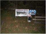 3
3 4
4 5
5 6
6 7
7 8
8 9
9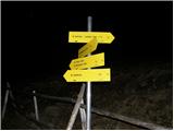 10
10 11
11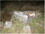 12
12 13
13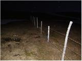 14
14 15
15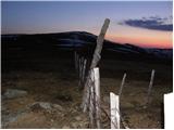 16
16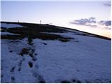 17
17 18
18
Discussion about the trip Ladinger Straße - Ladinger Spitz (Saualpe) (via Ladinger Hütte)
|
| VanSims5. 09. 2009 |
It might not be bad to write that for hikers from northwest and north Slovenia, the closer route is via Jezersko, Velikovec (Völkermarkt) and from there on the federal road to Wolfsberg, if you don't have a vignette. If you do, go via Ljubelj and at Celovec on the motorway and exit at Wolfsberg. In both cases then continue as written above.
As for the tour, for beginners with less fitness, the route via Wolfsberger Hütte might be more suitable. I returned via this route over Ladinger Hütte and it is quite steep and even worse marked. To Ladinger Hütte itself, however, it is a nice and not too steep forest road.
|
|
|
|
| pikica9217. 11. 2024 07:34:32 |
The description is good, we turned right at the fence to the cross (Getrusk), then along the ridge to Ladinger Spitz and returned via Wolfsberger Hütte. Made a nice circular path, misty cover in the valley, sun up top. The path is balm for the soul and body...
|
|
|
To post a comment you must log in:
If you do not yet have a username, you must first
register.