Gozd Martuljek - Bivak pod Špikom (direct way)
Starting point: Gozd Martuljek (750 m)
| Latitude/Longitude: | 46,4821°N 13,8378°E |
| |
Route name: direct way
Walking time: 2 h
Difficulty: easy marked way
Elevation gain: 674 m
Elevation difference along the route: 674 m
Map: Kranjska Gora 1:30.000
Recommended equipment (summer):
Recommended equipment (winter): ice axe, crampons
Views: 36.641
 | 1 person like this post |
Access to starting point:
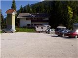
From Mojstrana we drive towards Kranjska Gora or vice versa, but only to the village Gozd-Martuljek, where we park on a parking lot near the bridge over the river Sava Dolinka (parking lot is located after the bridge, or before, if we come from Kranjska Gora).
Route description:
From the parking lot, we continue along the main road towards Kranjska Gora, but only to the spot where the cycling road branches off to the left (at the beginning of the cycling path there are also mountain signposts that direct us to the mentioned road). We follow the cycling road to the first crossroads, where we continue straight onto the macadam road (the cycling road turns right), which quickly brings us to the next crossroads.
We continue right and follow the road closed to traffic to the TNP sign. Further, the path splits into two parts. We continue straight upwards on the steep cart track, which ascends along the right side of the Martuljška soteska gorge. The cart track, which mostly ascends through the forest, brings us after 15 minutes to a nice vantage point, where a view into the valley opens up. The path then goes back into the forest and continues ascending. A little further, the path from the waterfall joins us from the left, and a little further, the path to the bivouac under Špik branches off to the right.
We head onto this path, which initially ascends gently along the cart track. The wide path along which we ascend then leads us past a rock with the inscription "pod Špik".
When the path approaches the torrent, we encounter an orientation loop. The path to the left leads to the torrent and then disappears, while we continue straight past a smaller boulder on which there is a mark. After this, our path also approaches the torrent but does not cross it yet. Further on, it ascends along the right side and crosses it a little later. The crossing is not difficult, but the ascent from the torrent back to the path is somewhat harder. This section is only three meters long, so it does not cause us problems. The path ahead gently ascends through the forest to the next torrent, where there is a boulder with a large mark. The path ahead begins to ascend steeply up the forest-covered slope. In the middle of this ascent, we encounter a spring and a little further a pleasant bench. Further on, the forest becomes increasingly sparse, and the path brings us to the unvegetated slopes below Špik, where we encounter torrent deposits of stones. Here the path turns slightly right and goes back into the forest. After a few minutes of moderate ascent from the torrent deposits, we reach the bivouac under Špik.

The trip can be extended to the following destinations: Rigljica (3 h)
Photos:
 1
1 2
2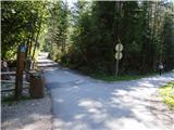 3
3 4
4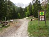 5
5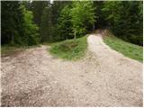 6
6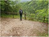 7
7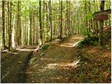 8
8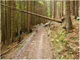 9
9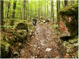 10
10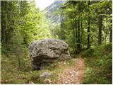 11
11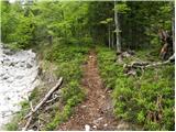 12
12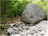 13
13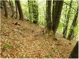 14
14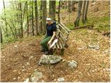 15
15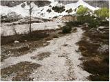 16
16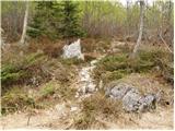 17
17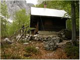 18
18
Discussion about the trip Gozd Martuljek - Bivak pod Špikom (direct way)
|
| JusAvgustin13. 10. 2010 |
Today for a nice half-day trip my colleague and I choose Krnica pod Srcem, we stop midway at bivak pod Špikom, we make a loop under the walls of Špik, Frdamanih polic and Rušice, we climb up to the rock barrier and return via the path through the gorge to the start. Superb colors and views, the higher we climbed the more "cloud cover" was forming
Lpp
|
|
|
|
| JusAvgustin5. 11. 2011 |
Today on such a gloomy day I take the gentler part of PN to "my Martuljek" It is really an oasis of peace and relaxation, even if sharpened curses were falling down. We do a loop from the old path to KV and almost to the bivouac Pod Srcem, we stop at Ingot. We didn't meet anyone, only the rainy drizzle cooled our faces. It is really an oasis of peace and relaxation, even if sharpened curses were falling down. We do a loop from the old path to KV and almost to the bivouac Pod Srcem, we stop at Ingot. We didn't meet anyone, only the rainy drizzle cooled our faces.
|
|
|
|
| aaja5. 11. 2011 |
OH
I'm wondering if this path would be suitable for me, is there anything to climb? ? ?
best regards Aja
|
|
|
|
| JusAvgustin5. 11. 2011 |
it's suitable even for moms with strollers , of course it's suitable. Above all, the beauty of the cirque Pod Srcem , of course it's suitable. Above all, the beauty of the cirque Pod Srcem
|
|
|
|
| aaja5. 11. 2011 |
Thanks
|
|
|
|
| J.P.2. 01. 2020 |
Winter equipment needed near the top i.e. last 50-100m elevation due to frozen snow. Around the bivouac all white and beautiful amphitheater with Špik in front :-) Safe steps. Lp
|
|
|
|
| Majdag13. 07. 2023 08:23:30 |
10.7. ...The path is getting steeper over the years, but being so close to Špik and the other peaks is nice. We continued to the source of Mrzla voda - Mahovje, which soon won't be there anymore. Fallen trees everywhere. The upper M. waterfall was closed that day, but there were many visitors. The lower M. waterfall is normally passable and the ramble was over. Nice!
https://jelenkamenmajdag.blogspot.com/2023/07/pod-spik-krnica-pod-srcem.html
|
|
|
|
| natasacraine3. 09. 2023 17:47:46 |
The path is still closed. Everything collapsed.
|
|
|
|
| Enka23. 06. 2025 22:04:53 |
Where do you park now, when in front of Triangel only guests are allowed, in front of the camp too, but at the camp where there were many parking spots, it's a construction site?
|
|
|
|
| LISAC24. 06. 2025 05:20:59 |
In front of Triangel, right next to the bike path, there is a plastic chain marking a few free public parking spots.
|
|
|
|
| Enka24. 06. 2025 11:41:23 |
|
|
|
|
| Ajda_Zitnik6. 07. 2025 13:34:06 |
Public parking spaces fill up quickly, so whoever comes first can park.
The trail is nicely maintained and even has some new markers in the upper part.
At the boulder where we turn right, there's now a small tree across the path that partially blocks the "wrong" path and should make orientation easier.
|
|
|
To post a comment you must log in:
If you do not yet have a username, you must first
register.