Breginj - Stol (Julian Alps)
Starting point: Breginj (550 m)
| Latitude/Longitude: | 46,262°N 13,4259°E |
| |
Walking time: 3 h 10 min
Difficulty: partly demanding marked way
Elevation gain: 1123 m
Elevation difference along the route: 1145 m
Map: Julijske Alpe - zahodni del 1:50.000
Recommended equipment (summer):
Recommended equipment (winter): ice axe, crampons
Views: 87.742
 | 3 people like this post |
Access to starting point:
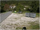
First, we drive to the center of Kobarid, and then we continue driving towards the border crossing Robič. Near the village Staro selo, we leave the main road which runs towards the border crossing Robič and we continue driving right in the direction of Breginj. Further, we follow a mainly ascending road to Breginj, where we park on a parking lot near the church.
Route description:
From the parking lot, we continue past the church (we bypass it on the right side) and we continue the ascent on an asphalt road in the direction of Stol and Muzec. The road at first ascends through the village, at the crossroads we follow it in an already known direction. Higher, the road loses its asphalt surface and past an old mill brings us to a marked crossroad, where we continue slightly right (left church of Marija Snežna). The road which continues to moderately ascend, soon brings us to a marked crossing, where a marked footpath to Muzec (Musc) branches off to the left.
We continue in the direction of Stol and we still continue the ascent on a macadam road, and it soon brings us to the next marked crossroad. We again continue right in the direction of Stol and Sveta Marjeta (left Muzec) on further at first gently sloping road. After a few minutes of additional walking, blazes point us to the left on a marked footpath which higher a few times crosses the already mentioned forest road. The mentioned footpath (or also the road), which starts ascending steeper and steeper, we then follow all the way to the church of Sveta Marjeta (973 m).
From the church, we continue on a steep footpath which quickly brings us out of the forest on panoramic grassy slopes. When we step out of the forest, a wonderful view opens up on Breginjski kot and peaks which surround the mentioned kot. The path ahead passes on an indistinct side ridge, on which we then ascend steeper and steeper. Higher, the path brings us to an unmarked crossing, where we continue straight (left slightly downwards a transverse path to Klatnica) and we continue the ascent on the already known indistinct ridge. The path from which increasingly beautiful views open up on the Adriatic Sea, Breški Jalovec and the ridge of Muzcev, higher ascends even steeper, and then turns a little to the right, where it crosses very steep and mainly when wet dangerous for slipping slopes. Further the path slightly flattens and brings us on the main ridge of the longest ridge in the Julian Alps (ridge is long around 30 km).
When we step on the ridge, we continue right (left Muzec) and we continue the ascent on a very panoramic ridge. The path which at first slightly descends and offers nice views on the Kanin massif, a few times for a short time steeply ascends and after approximately 15 minutes of additional walking brings us to the summit of Stol.

Photos:
 1
1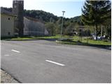 2
2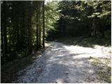 3
3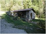 4
4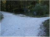 5
5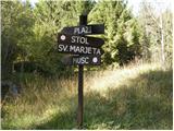 6
6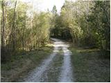 7
7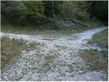 8
8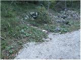 9
9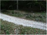 10
10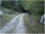 11
11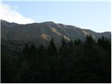 12
12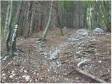 13
13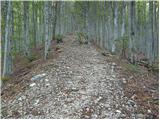 14
14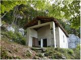 15
15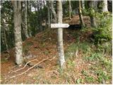 16
16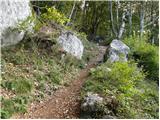 17
17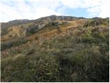 18
18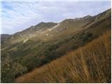 19
19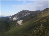 20
20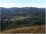 21
21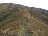 22
22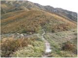 23
23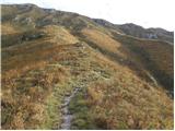 24
24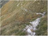 25
25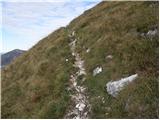 26
26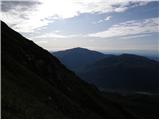 27
27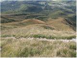 28
28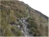 29
29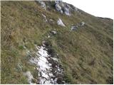 30
30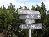 31
31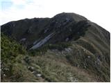 32
32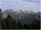 33
33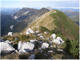 34
34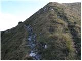 35
35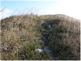 36
36 37
37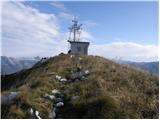 38
38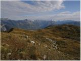 39
39
Discussion about the trip Breginj - Stol (Julian Alps)
Show older messages
|
| madronščica29. 03. 2009 |
Hello! I'm interested if anyone has recently been to Kobarik Stol, what are the conditions. Thanks in advance for the information.
|
|
|
|
| noos1. 05. 2009 |
Where can we get the stamp, as we didn't find it at the top. There's still a lot of snow on the western side. Why not place the stamp in an accessible place so that it can be obtained even in the snow. Thanks for the answer.
|
|
|
|
| smidov david3. 05. 2009 |
On the Kobarid Stol the stamp is where the box with the logbook is attached to the hut. So that it can be obtained even in the snow because it is about 1.20 meters high
|
|
|
|
| grahlck31. 05. 2009 |
Can someone tell me how much time would be needed for the circular tour Breginj-Kob. Stol-Veliki Muzec-Breginj? Some pictures would also be recommended. Thanks.
|
|
|
|
| fred31. 05. 2009 |
Sadly I don't have photos, regarding timing it's like this: breginj-stol 2.5 hours stol-muzec 1.5 and down to the valley 1.5 hours
in this season you need to start early because the sun hits your back hard there and the path is quite steep
|
|
|
|
| grahlck6. 06. 2009 |
Is there no more snow on this circular trail?
|
|
|
|
| grahlck8. 06. 2009 |
Thank you very much fred.
|
|
|
|
| ana25. 06. 2009 |
Today my friend and I started in Breginj to Kobariški Stol, then along the ridge to Kobarid. Despite raindrops, we had nice views of the neighboring peaks and the valley. Full of flowers, great trip.
|
|
|
|
| jelka0928. 07. 2009 |
Ana, I'm interested how long it took you to hike. Thanks.
|
|
|
|
| smrekca28. 07. 2009 |
From Breginj to Kobariški Stol it takes 2.5 to 3 hours, then to Kobarid another 2.5 to 3 hours.
|
|
|
|
| maiden11. 02. 2010 |
Does anyone know what the conditions are like up there?
|
|
|
|
| klavdipo21. 04. 2010 |
Is there still any snow on the path?
|
|
|
|
| _Abuh_21. 04. 2010 |
I'm going up on Saturday and I'll tell you on Saturday.
|
|
|
|
| klavdipo21. 04. 2010 |
He, he, me too, if health allows...
|
|
|
|
| sim11122. 04. 2010 |
On the ridge, the last 20 minutes before the summit there was still about a meter of snow on April 11.
|
|
|
|
| _Abuh_25. 04. 2010 |
I was up there yesterday but there's only a little snow here and there in shady spots. 
|
|
|
|
| mizuno12. 08. 2010 |
Yesterday we were at Breginj Stol after the church of St. Marjeta a swarm of bloodsucking flies attacked us after 10 min. of walking in the rising sun, which mercilessly attacked our legs.  even today we have blisters and sore legs. even today we have blisters and sore legs.
|
|
|
|
| mizuno12. 08. 2010 |
but nevertheless we reached the summit and stamped the logbook
|
|
|
|
| mizuno12. 08. 2010 |
recommendation: apply mosquito or insect repellent spray
|
|
|
|
| bperc16. 11. 2010 |
Saturday, 13.11.2010.
Most of the time everything was in fog, but when we reached the top, the sun finally appeared, so we at least got a bit of the view. The last 30 minutes of walking were covered with snow, about 20-30 cm. After approximately 5 hours and 15 minutes we safely arrived back at the car. The trip was definitely interesting and I recommend it.
[img]http://img502.imageshack.us/img502/3533/83497153.jpg[/img]
[img]http://img819.imageshack.us/img819/661/48642291.jpg[/img]
|
|
|
|
| Benč.16. 11. 2010 |
For this time of year super tour, nice if you hit a nice day, we were really shrouded in fog, but on the top it was so much nicer when numerous peaks protruded from the fog. Nice view! Don't forget, on the top there is really some 10 cm of snow (for tasting)
|
|
|
|
| dida14. 04. 2011 |
and who knows what the current conditions on this trail are?
|
|
|
|
| IgorZlodej14. 04. 2011 |
For the moment I don't know, nor do I know what interests you, trail marking, overgrowth, fallen trees, possibly snow. You need to be more specific with the question. As seen from the valley, there is no snow on the southern slopes, and snow shouldn't be a problem for a real hiker who has crampons anyway.
|
|
|
|
| dida15. 04. 2011 |
I'm mainly interested in snow conditions and trail marking, but all information is useful anyway
|
|
|
|
| IgorZlodej15. 04. 2011 |
When I wrote, the southern side was completely dry, behind the ridge there is still some snow, but it shouldn't be a problem. best regards
|
|
|
|
| matdra28. 05. 2012 |
Very interesting tour, physically demanding and excellent preparation for summer season of conquering higher summits. But almost unvisited (probably because no hut and obligatory strudel afterwards .
|
|
|
|
| ales5028. 05. 2012 |
Lately noticed that quite a few fossil specimens are found on these summits and below them, besides the war ones of course
|
|
|
|
| kalkulator31. 03. 2013 |
Hello! I'm wondering if anyone has been to Kobariški Stol recently? Which path is more trodden and marked?
We plan to set off from Breginj. First time!
Best regards
|
|
|
|
| igor b.1. 04. 2013 |
Hi, I'm a local from Breginj, the path from Breginj to Stol and other paths on the ridge are well maintained and marked but unfortunately currently very difficult due to a lot of snow on the ridge, it's better to wait another week or two, also due to avalanches and besides Kobariški Stol no longer exists, info about paths on the Stol ridge write to:
igor.breginj33@gmail.com or to pdkobarid@gmail.com
Mountaineering Association Kobarid Breginj section
Nice hiking regards
|
|
|
|
| kalkulator2. 04. 2013 |
Hello!
Yesterday we went to Stol from Breginj, but we had to turn back just below the ridge as there was a lot of fresh snow. The summit of Stol will indeed have to wait a bit longer. Nice hiking regards
|
|
|
|
| senik3. 04. 2013 |
Hello!
I also tried, we were probably together and it's only possible up to the ridge, as a lot of snow has fallen in the last few days. Need to wait at least three more weeks.
Best mountain regards!
|
|
|
|
| balon27. 07. 2013 |
Hello,
we are a family 2+2 (5+7 years) and wonder if it is possible to park closer (say picture 6) or if the car has to be left by the road? 5 hours of walking is quite a lot for the kids and one less hour of walking would make a big difference.
Thanks and best,
Balon
|
|
|
|
| bos27. 07. 2013 |
yes you can park near picture 6 - now there are new iron signposts or even higher depending on your vehicle
check under Current conditions - Kobariški Stol
|
|
|
|
| balon27. 07. 2013 |
thanks for the reply and we wish safe steps.
Balončki
|
|
|
|
| balon28. 07. 2013 |
one more and I promise it's the last question, I won't bother anymore
how much walking is there from picture 11? I'm asking because I don't know this area, we're from the Kamnik-Savinja Alps and if anyone has a comparison I'd be very happy.
Thanks and best regards
Balončki
|
|
|
|
| Strucko28. 07. 2013 |
We drove to picture no. 8. From picture no. 11 it's about 2 hours good walking to the top, considering the kids. About 45 minutes you go through the forest, then you come out onto the grassy slope. I suggest an early start, because the sun starts scorching there.
|
|
|
|
| balon29. 07. 2013 |
thanks for the reply.
|
|
|
|
| frenk452. 03. 2014 |
I'm wondering if the hut at the summit is serviced and if it's possible to overnight there lp
|
|
|
|
| miri2. 03. 2014 |
frenk45, there is no hut at the summit.
|
|
|
|
| frenk452. 03. 2014 |
well there is some transmitter
|
|
|
|
| ajax3. 03. 2014 |
only a transmitter
|
|
|
|
| SunnyDay3. 04. 2014 |
With a car you can easily drive to the intersection in photo No. 8, i.e. to the spring of Bela.
The path to the summit is nicely cleared, although the forest in one section was damaged by ice storm . Snow is only on northern slopes, from the south (from Breginj) the path is almost completely dry or snow on the ridge can be nicely avoided.
But we didn't find the stamp at the top. It is mentioned above that it is attached to the "hut", but there was neither a logbook nor a stamp anywhere.
In summer it's hard to imagine climbing to the top on a steep slope in the sun. Already on 31.3. we got quite sunburned.
|
|
|
|
| Laščan4. 04. 2014 |
Two years ago, when I was at Breginjski Stol, the stamp was attached to a rock, next to the logbox and a statue of Mary (like on Matajur. If memory serves me right, the mentioned rock is a few meters from the building at the transmitter.
|
|
|
|
| igor b.5. 04. 2014 |
The stamp and logbook are still attached to the rock 5m from the "hut". Unfortunately no more Mary and cross
Mountain lovers and other Stol fans - Kobariški Stol DOES NOT EXIST!!!
for more info on the Stol mountain range write to: igor.breginj33@gmail.com or to pdkobarid@gmail.com
Nice mountain greetings!
|
|
|
|
| ljubitelj gora5. 04. 2014 |
For us who don't know those parts, it will be Stol above Kobarid , although locals say Breginjski Stol.
|
|
|
|
| balon4. 05. 2014 |
I'm wondering if you can drive by car to picture 11?
If yes, how much walking to the top?
Baloncki
|
|
|
|
| Branee4. 05. 2014 |
To the mountains one walks on foot
|
|
|
|
| balon4. 05. 2014 |
Does anyone have a more concrete answer?
|
|
|
|
| klm4. 05. 2014 |
Yes, but damage to the car, even if it's a Skoda. Otherwise it depends on physical fitness: from 45 minutes to about 3 hours.
|
|
|
|
| igor b.5. 05. 2014 |
If you like hiking in the mountains, it's not hard for you to leave the car in Breginj and continue nicely on foot, that's why we have also arranged mountain trails from Breginj to the Stol range.
For more info on the Stol range, write to igor.breginj@gmail.com
Best regards!
|
|
|
|
| Smetar5. 05. 2014 |
Igor, the link to the hiking club is also incorrect. (it's .com instead of .si)
PD Kobarid
Regards
|
|
|
|
| el rocco30. 04. 2015 |
Yesterday my wife and I did a great trip that I recommend to everyone ). Since we are from Gorenjska, we took the car train from Bohinj to Most na Soči, then by car to Breginj and on foot to the top of Stol. On this occasion I would praise the PD that maintains the mentioned trail, as it is very neatly marked all the way, so you practically cannot miss the direction to the summit. However, (as I saw from the logbook) the summit is quite poorly visited.... Probably the reason is that there is no hut up there, or that the ascent is not as innocent as it seems ). It's not too bad, but you definitely need some fitness because it is quite steep (especially above the tree line). My opinion is also that Stol is better to visit now in spring or autumn and obligatorily in dry weather. Firstly because above the tree line there is not even a millimeter of shade and if heat catches you there you are done...., in dry weather because the rocks are already slippery when dry, and the trail is so steep that if you slip there you won't stop easily on the grass.. ). But anyway. Visiting Stol is a wonderful experience, so go ahead without fear, put your feet on the path. Ah, one more thing... Regarding the starting point. Whoever wants to shorten the trail and does not intend to go from Breginj, follow the signs for Stol and drive by car along the forest road until it ends or to the red sign where it says Sv.Marjeta 15 min., Stol 2h. You cannot get closer by car.
LPP
|
|
|
|
| igor b.30. 04. 2015 |
Thanks for the praise, we will continue to strive so that you have a good time, especially safe on our Stol mountain range.
Best regards!
Igor Baloh
PD Kobarid section Breginj.
|
|
|
|
| mitja g9. 05. 2015 |
mountain lover:
given that correct names of our mountains are already used on most websites and maps, it would be time to use correct names also in the heads of every individual.
Therefore I ask every individual to use the names listed above by our member Igor Baloh, and ask everyone to point out to anyone who hears a different name that it is incorrect.
Thanks for understanding
chief of the marking section PD Kobarid
Mitja Gruntaar
|
|
|
|
| marieto6025. 01. 2017 |
Hey!
Which path is better (by car!!!): from Sedlo or from Žaga?
On Google you can see a nice road connecting both sides of Stol...
Nice hiking day to all!
from Marieto
|
|
|
|
| maregol25. 01. 2017 |
So, the "road" from Breginj is not a road, but even in summer it's quite poorly maintained macadam... the road from Žaga or from Učje is in better condition, since paragliders drive on it, but it's not exactly a good example for other macadams either.
But given the current conditions on Slovenian roads, I think neither is drivable now....have to go from the valley!
|
|
|
|
| ML318. 07. 2019 |
On 14.7.2019 we managed to drive to planina Božca from the direction of Učje with a personal car. The road is torn up, I absolutely advise against it for everyone with low cars and those unaccustomed to bad macadam. It can be especially adrenaline-pumping during or after rain. The road to Breginj is worse.
|
|
|
|
| CarpeDiem24719. 08. 2019 |
Which path is the most scenic and interesting from this perspective if we tackle it from the valley without "tin" shortcuts?
|
|
|
|
| winni5. 05. 2021 08:29:27 |
If the parking lot by the church is full, you can also park along the forest road that leads to the church of St. Marjeta.
You can also avoid the initial steep ascents in the forest by taking the aforementioned gravel road.
|
|
|
|
| ucakakla2. 08. 2021 18:31:22 |
Winni, is it possible to park also at the church of St. Marjeta?
|
|
|
|
| bo_zl2. 08. 2021 20:02:19 |
You can park opposite the church in Breginj, there are quite a few parking spots, I'd say on a fairly new parking lot. Then there's also space for a few cars by the church, where the buses park.
|
|
|
|
| ucakakla3. 08. 2021 09:34:29 |
Bo_zl, thanks, but I meant at the church of St. Marjeta - higher up along the path.
|
|
|
|
| lubadar3. 08. 2021 09:43:40 |
You can park somewhere around there, like picture 6, and the road further on is not always in the best condition either.
|
|
|
|
| ucakakla25. 03. 2022 08:28:27 |
I would ask for info on the current conditions for the ascent to Stol, especially if there's still a lot of snow on the ridge? Would it maybe be better to wait a bit longer or is the path already snow-free? Thanks.
|
|
|
|
| pohodnik5525. 03. 2022 17:50:43 |
Was yesterday on K. Stol from Breginj, then traverse to Muzcev and descent to Breginj from the bivouac. The path to Stol is completely snow-free, only on the summit is there still snow which poses no problems. Completely different story if you want to go to Muzcev. On the north side it's still real winter with plenty of snow, on the south side you posthole on the ridge as it's already too warm early in the morning. Good luck. Best TONE
|
|
|
|
| pohodnik5525. 03. 2022 18:18:59 |
I'd just add this, since I see what issues some have with naming this mountain. If the peak is simply located near a larger very recognizable place, I don't think it's at all wrong if we non-locals name it after that place due to possible mix-ups as there are quite a few peaks with that name in Slovenia. Let it be STO, Breginjski Stol or Kobariški Stol, important that we know it's beautiful and it's Ours. (Big problems of small people). And nice mountaineer's greeting. Tone.
|
|
|
|
| Mini_Ini26. 01. 2023 14:08:14 |
Hi, has anyone been to the summit these days? How's the trail and snow, is there any?
|
|
|
|
| mirank26. 01. 2023 19:17:49 |
Check the webcam for Učja and you'll see.
|
|
|
|
| darinka426. 01. 2023 21:15:16 |
If I think about it, it's not even high. But precisely because of the abundance of snow and wading through it, Marijan and I turned back about twice. Now there's probably a lot of snow. And as far as I remember, the path from Učja can surprise with some avalanche on the way. We saw traces of an avalanche on the path when we hiked there last year.
|
|
|
|
| Tajka6727. 04. 2023 19:43:26 |
Just the right day to visit this Stol. Perfect weather for hiking, switchbacks left and right just don't end. Clouds were hiding the sun, but no problem. From Breginj completely dry, just some snow traces left at the top. Best regards to all
|
|
|
To post a comment you must log in:
If you do not yet have a username, you must first
register.