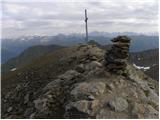
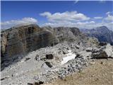
 | End of road on Vogar - Mala Zelnarica (via Štapce)
Mala Zelnarica is a 2310-meter-high peak situated between the Valley of the Triglav Lakes and the Za Kopico Valley. From the summit, which has a ...
5 h 15 min |
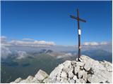
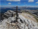
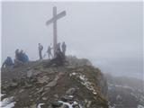
 | Volkzeinalm - Degenhorn
Degenhorn, at 2,946 meters, is a peak in the southwestern part of the High Tauern. From the summit, which features a cross and summit logbook box...
3 h 30 min |
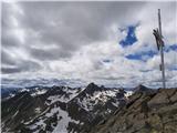
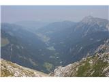
 | Untere Wolayeralm - Rauchkofel
North of Monte Coglians, the highest peak of the Carnic Alps, lies the 2,460-meter-high Rauchkofel. From the summit, which features a cross and a...
3 h 45 min |
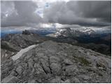
 | San Martino - Cima della Rosetta
Cima della Rosetta is a 2,743-meter-high peak rising above the settlement of San Martino. From the summit, where a cross stands, there is a nice ...
3 h 40 min |
 | Rifugio Pederü - Muntejela de Sennes
Muntejela de Sennes (Monte Sella di Sennes) is a 2,787-meter-high peak in the Fanes-Sennes-Prags Nature Park. The summit is located west of the M...
3 h 30 min |
| Rifugio Ra Stua - Muntejela de Sennes
Muntejela de Sennes (Monte Sella di Sennes) is a 2,787-meter-high peak in the Fanes-Sennes-Prags Nature Park. The summit is located west of the M...
3 h 30 min |
 | Zettersfeld - Schleinitz
Schleinitz is a 2,905-meter-high peak in the southern part of the Schober mountain group. From the summit there is a very nice view of all the ma...
3 h 30 min |
 | Lech da Sompunt - Piz de Puez / Puezspitz (path 15)
Piz de Puez (eastern summit) is a 2,913-meter-high peak in the Puez mountain group. A marked path leads to the summit, which is relatively easy t...
6 h |
| Passo Gardena - Piz de Puez / Puezspitz
Piz de Puez (eastern summit) is a 2,913-meter-high peak in the Puez mountain group. A marked path leads to the summit, which is relatively easy t...
4 h 30 min |
| Colfosco - Piz de Puez / Puezspitz
Piz de Puez (eastern summit) is a 2,913-meter-high peak in the Puez mountain group. A marked path leads to the summit, which is relatively easy t...
4 h 45 min |
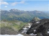
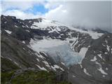 | Parkplatz Innerfragant - Goldbergtauernkopf (via Fraganter Scharte)
Goldbergtauernkopf is a lesser-known peak between the notches Fraganter Scharte and Niedere Scharte above the Mölltaler Gletscher ski slope. From...
6 h |
 | Sant'Uberto - Col Bechei
Col Bechei (also Col Becchei, German Pareispitze, Italian Monte Parei) is a 2,794-meter-high peak above the Valle di Fanes and Valle di Rudo vall...
4 h 45 min |
| Rifugio Pederü - Col Bechei
Col Bechei (also Col Becchei, German Pareispitze, Italian Monte Parei) is a 2,794-meter-high peak above the Valle di Fanes and Valle di Rudo vall...
3 h 55 min |
| Capanna Alpina - Col Bechei
Col Bechei (also Col Becchei, German Pareispitze, Italian Monte Parei) is a 2,794-meter-high peak above the Valle di Fanes and Valle di Rudo vall...
4 h 15 min |
 | Sportgastein - Vordere Geislspitze / Vorderer Gesselkopf (via Hagener Hütte)
Vordere Geislspitze (also Geiselspitze) is a mountain in the Hohe Tauern in Austria, in the Goldberge group. The mountain name has numerous varia...
5 h 15 min |
 | Capanna Alpina - Bivacco Baccon Barborka
Bivacco Baccon Barborka is a small bivouac with four bunks. It is located near the summit of Furcia Rossa II, where large ruins from World War I ...
3 h 50 min |
| Sant'Uberto - Bivacco Baccon Barborka
Bivacco Baccon Barborka is a small bivouac with four bunks. It is located near the summit of Furcia Rossa II, where large ruins from World War I ...
4 h 35 min |
| Rifugio Pederü - Bivacco Baccon Barborka
Bivacco Baccon Barborka is a small bivouac with four bunks. It is located near the summit of Furcia Rossa II, where large ruins from World War I ...
4 h 10 min |
 | Maria Waldrast - Serles (western approach from Maria Waldrast)
Serles is one of the most recognizable, admired, and visited peaks around Innsbruck. This three-headed pyramidal mountain, together with Hafeleka...
3 h 30 min |
 | Kühtai - Kraspesspitze (western approach from Kühtai and via saddle Finstertal)
Kraspesspitze is a somewhat neglected 2,954 m high mountain rising above the reservoir lake and the Finsterstal saddle. Unlike the nearby Sulzkog...
4 h |
 | Parkplatz Tappenkarweg - Weißgrubenkopf (Parkplatz Tappenkarweg - Weißgrubenkopf)
Weißgrubenkopf is a 2,369-meter-high panoramic mountain at the far west of the Lower Tauern in the Austrian state of Salzburg. It is located dire...
3 h 30 min |