Hiking-trail.net
hiking-trail.net
Login
Login
Username:
Password:
Login
Not registered yet? Registration.
Forgot password?
Karavla

Karavla

Country: Slovenia
Latitude/Longitude: 46,8738291°N 16,2464485°E
Altitude: 347 m
Type: Bivouac
Weather forecast:
Sa
Su
Mo
Tu
We
Description:
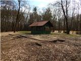
Karavla is a bivouac located at an elevation of 347 meters. The bivouac is located in country Slovenia 3 km east-northeast from the center of Čepinci and 4 km north-northeast from the center of Markovci near the border with Hungary
Images:
Karavla
Show map
Points in the vicinity:
Detailed descriptions
Border stone A 115 (353m)
1,0 km west-northwesterly
Budinci (285m)
1,2 km southeasterly
Katin breg / Katalin-hegy (367m)
1,5 km west-northwesterly
Gorički breg (362m)
2,4 km west-southwesterly
Webcams
Čepinci
2,0 km west-southwesterly
Hodoš
8,2 km southeasterly
Mačkovci
11,5 km south-southwesterly
Kuzma
13,3 km west-southwesterly
Panoramas
Sotinski breg (Kugla) (418m)
17,0 km west-southwesterly
Serdiški breg (Rdeči breg) (416m)
18,4 km west-southwesterly
Bukovniško jezero (189m)
23,4 km south-southeasterly
Jeruzalem (338m)
44,4 km southerly
Starting points
MP Čepinci
1,6 km westerly
Andovci / Orfalu
1,8 km east-northeasterly
Budinci
2,5 km south-southeasterly
Čepinci (cemetery Čepinci)
2,8 km southwesterly
         
Copyright © 2026 Hiking-trail.net, Terms of use, Privacy and cookies