Zgornja Bistrica - Sveti Trije kralji (via Bistriški vintgar)
Starting point: Zgornja Bistrica (375 m)
Route name: via Bistriški vintgar
Walking time: 3 h
Difficulty: easy marked way
Elevation gain: 806 m
Elevation difference along the route: 820 m
Map: Pohorje 1:50.000
Recommended equipment (summer): helmet
Recommended equipment (winter): helmet, ice axe, crampons
Views: 65.826
 | 5 people like this post |
Access to starting point:
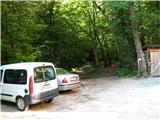
From the highway exit Slovenska Bistrica-jug, through the roundabout to the intersection of the old Maribor-Celje road, where we turn right to the center of Slovenska Bistrica (approx. 600 m), where at the traffic lights by the church we turn left. We mostly drive straight, right past the Impol factory (roundabout – second exit), over the bridge across Bistrica, at all further crossroads we drive straight, through the field to the end of the road by the water plant, where we park the car. From the center of Slovenska Bistrica just under 4 km.
Route description:
From the parking lot into the forest, where initially a wide and gentle path runs along the left bank of Bistrica, which we then cross via a metal footbridge. We walk in close proximity to Bistrica and slowly ascend, soon we encounter a signpost for the Roman quarry, in which during the time of the Roman Empire they extracted white marble for artistic creations. (*** To view the quarry we turn right over the footbridge, after a few minutes we are there, return along the same path).
The path becomes steeper, after a while Bistrica is already deep below us. The signpost alerts us to a natural feature, namely the 20 m high multi-tiered waterfall Šum, we continue straight on the path. (*** To view Šum we choose the right narrow path that leads us down to the waterfall, from there we continue left uphill until we rejoin the main path, the total walking time extends by approximately 20 minutes).
Upon continuing the path we encounter a signpost for Ančnikovo gradišče, but we turn right over a wooden footbridge across a tributary of Bistrica, across marshy terrain and then across a metal footbridge to the left bank of Bistrica. Further on the path becomes steeper, we admire the rapids and waterfalls of Bistrica, along the path we repeatedly notice remains of sawmills and mills, we are also surprised by a bench for resting. We also encounter an exposed spot that we must cross carefully.
In the upper section the path becomes gentler and still runs along Bistrica, whose flow also calms somewhat, at the intersection we bypass the old mill on the right side and follow the markers. Through the trees on the left side we glimpse a larger clearing, the path turns back into the forest, where we can view the Maroltova jelka, which unfortunately is already quite decayed. Further on the path for the first time from the start brings us out of the forest onto open ground, where along the left side we cross a larger meadow to the macadam road, where we turn left over the bridge and immediately after at the next intersection right. We are below Močnik, 2/3 of the path is behind us. After 200 m of walking along the road we turn right (pay attention to the poorly visible signpost on the electricity pole on the left side of the road), in the forest we head left and continue in moderate steepness along the well-visible path. In between we cross an asphalt road once, a little before the end of the path the path from Veliki Tinja joins us from the left.

Photos:
 1
1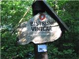 2
2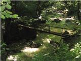 3
3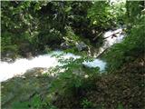 4
4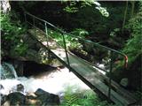 5
5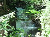 6
6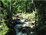 7
7 8
8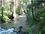 9
9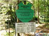 10
10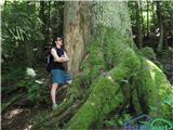 11
11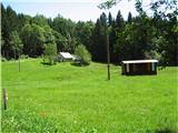 12
12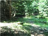 13
13
Discussion about the trip Zgornja Bistrica - Sveti Trije kralji (via Bistriški vintgar)
|
| damijanp3. 11. 2008 |
We went along the path through Bistriški Vintgar (not quite to the Three Kings) on Sunday. Some snapshots are here:
Bistriški Vintgar
|
|
|
|
| bostjan857. 11. 2008 |
We went in August, also not to the three kings, it was quite strenuous.http://outdoors.webshots.com/album/565597648lMYuKu
|
|
|
|
| štajerc13. 04. 2009 |
I walked the path on Saturday and I must say it is very nice and suitable for family walks.
|
|
|
|
| damijanp26. 06. 2010 |
We used yesterday's holiday for a nice family circular hike - through Vintgar to the Three Kings and then via Planina and Tinje back to the starting point. Some snapshots are at: Trije kralji
|
|
|
|
| Marky13. 01. 2012 |
This weekend I did an easy tour from Smrečno to the Three Kings and further to Osankarica.. Super path.. perfect for relaxation.. The path is super.. trampled.. up to cca. 900m a.s.l. without snow, then a little bit but just worth mentioning
You can view the photos at M-foto.si
|
|
|
|
| pohodnik384. 05. 2013 |
27.4. walked this path which was beautiful as always. Lots of water in Bistriški Vintgar, interesting to watch how it rushes down the valley with its unstoppable force. I extended the path to Črno jezero, now the conditions are probably different as the snow is melting rapidly, but it's true that at Treh kraljih they should mark the path to Črno jezero a bit better so people don't get lost...
Some video impressions from the path
Best regards! Tone
|
|
|
|
| stipi6922. 03. 2014 |
Beautiful path, nice Sunday hike for socializing, worth stopping here and there, looking at some "waterfall", the Roman quarry for example, feast your eyes, then push on to the three kings 
|
|
|
|
| gajstz9. 04. 2016 |
3:45 one way to the three kings, then the same back? 7 hours is no small thing...
|
|
|
|
| BibaS13. 04. 2016 |
Yes you can arrive in 3 hours even at moderate pace or sooner if you speed up a bit.
Otherwise walk up, for the descent call someone to pick you up with the car below
|
|
|
|
| seinfeld29. 05. 2017 |
We went on this path yesterday, only to the spruce, which is exactly 9km from the parking lot and back. Nice, easy tour, but best done in dry weather. In wet it can be quite unpleasant and dangerous around the waterfall.
Also recommended for small children.
|
|
|
|
| de-jan-ja5. 08. 2017 |
Today we went on this path and I have to say we were very disappointed with the markings. Through the vintgar to Močnik everything is fine, further on it's worse, many junctions and no markings so we got lost a few times. If you don't know the path, you easily stray off course. I think those responsible should make more effort for markings considering it's a nice and interesting tour that some set off on for the first time!
|
|
|
|
| mosovnik6. 09. 2018 |
Since for a long time already (since winter) none of those responsible for this beautiful path (PD markers) have "noticed" fallen trees on the path, two nature lovers have removed some obstacles and the chainsaw was very useful for that. Higher up there is still some work left.
Good luck and I hope I've nudged someone and woken them from hibernation.
|
|
|
|
| pohodnik3824. 03. 2019 |
Yesterday I did the mentioned path through Bistriški Vintgar to the Three Kings and continued to Črno jezero. Path normally passable, only from Močnik onwards there could be a sign and more markings on the path. From Three Kings to Črno jezero there's still some snow on the path otherwise normally passable. It was great
PICTURES and personal impressions from the path
Regards! Tone
|
|
|
|
| pasteta23. 07. 2019 |
We went today (22.09.2019) to Maroltova jelka and further around to Sv. Urh and back. You can't go to the quarry anymore, no bridge. Path to jelka is bad, bridge barely stands (wooden part). The path itself is quite overgrown. From jelka onwards catastrophically poorly marked path. From the church back only one signpost!??
The path itself is WONDERFUL!
|
|
|
|
| Hribolazec816. 02. 2024 19:37:38 |
Greetings, what's the path like now, are the bridges repaired and passable, and the rest of the path? Thanks
|
|
|
|
| Andrej4523. 02. 2024 23:59:11 |
@Hribolazec81 those bridges that are talked about are not needed for the trail itself, but for viewing the sights across the stream along the trail.
|
|
|
To post a comment you must log in:
If you do not yet have a username, you must first
register.