Šajda / Schaidasattel - Hochobir (Ojstrc)
Starting point: Šajda / Schaidasattel (1069 m)
| Latitude/Longitude: | 46,4791°N 14,4675°E |
| |
Walking time: 3 h
Difficulty: easy marked way
Elevation gain: 1070 m
Elevation difference along the route: 1070 m
Map: Karavanke - osrednji del 1:50.000
Recommended equipment (summer):
Recommended equipment (winter): ice axe, crampons
Views: 28.904
 | 2 people like this post |
Access to starting point:
A1) From the highway Ljubljana - Jesenice, we take the exit Ljubelj (Tržič), then continue driving in the direction of Celovec / Klagenfurt. After the Ljubelj tunnel, the road starts descending, and we follow it to the crossroad where slightly to the right and downward the road toward the settlement Borovlje / Ferlach branches off. The road, which continues descending, quickly brings us to the mentioned settlement, where we soon cross the railway track. Just a little after the track, we join another road, which we follow to the right, driving toward the settlement Sele pri Cerkvi / Zell - Pfarre. Further on, the road starts ascending toward the mentioned settlement, which is situated at approximately 950 meters above sea level. Next follows a gradual descent to the settlement Sele - Borovnica / Zell - Freibach and to the crossroad, where the road past Borovnica dammed lake joins (description A2). Here we continue right toward the settlement Sele - Šajda / Zell - Schaida and Železna Kapla / Bad Eisenkappel. We follow the road toward Železna Kapla only to the alpine pass Šajda / Schaidasattel, where we park on the well-maintained asphalt parking lot. From the entrance into the tunnel to the starting point, it is approximately 33 km
A2) From the highway Ljubljana - Jesenice, we take the exit Ljubelj (Tržič), then continue driving in the direction of Celovec / Klagenfurt. After the Ljubelj tunnel, the road starts descending, and we follow it to the crossroad where slightly to the right and downward the road toward the settlement Borovlje / Ferlach branches off. The road, which continues descending, quickly brings us to the mentioned settlement, where we soon cross the railway track. Just a little after the track, we join another road, which we follow to the left (right Sele pri Cerkvi / Zell - Pfarre (description A1)), then at the next slightly larger crossroad to the right. At the end of Borovlje, we arrive at a roundabout, from which we continue again in the direction of Železna Kapla. We continue driving through the villages Medborovnica / Unterferlach, Ostrovca / Ostrouza, Trata / Tratten, Glinje / Glainach, Vesca / Dörfl, Ždovlje / Seidolach, Dobrova / Dobrowa, Kočuha / Gotschuchen, Šmarjeta v Rožu / Sankt Margareten im Rosental, Dolnja vas / Niederdörfl to the village Zgornja Vesca / Oberdörfl. Just a little after the last-mentioned settlement, we arrive at a slightly larger crossroad, where we continue right in the direction of the settlement Sele / Zell (Pri Cerkvi / Zell - Pfarre, Borovnica / Freibach and Šajda / Schaida). Further, we drive past Borovnica dammed lake / Freibach - Stausee, after which the road becomes somewhat narrower, then quickly brings us to the place where we join the road from the settlement Sele pri Cerkvi (description A1). Here we continue left toward the settlement Sele - Šajda / Zell - Schaida and Železna Kapla / Bad Eisenkappel. We follow the road toward Železna Kapla only to the alpine pass Šajda / Schaidasattel, where we park on the well-maintained asphalt parking lot. From the entrance into the tunnel to the starting point, it is approximately 38.5 km
B) Via the border crossing Jezerski vrh or Pavličev vrh, we drive into Austria and continue driving toward Železna Kapla / Bad Eisenkappel. In Železna Kapla, we leave the main road and continue left in the direction of the settlement Obirsko / Ebriach and settlement Sele - Šajda / Zell - Schaida. After a few kilometers, we arrive at a crossroad, where to the left branches the road toward the village Korte / Trögern, and we continue straight and follow the ascending road to the pass Šajda / Schaidasattel, where we park on the parking lot on the left side of the road. From the border crossing Jezerski vrh to the starting point is a little more than 28 km, from the border crossing Pavličev vrh approximately 30 km.
C) First, we drive to Dravograd, then continue driving toward the border crossing Vič and the settlement Labot / Lavamünd, Austria. In the mentioned settlement, we go left and then drive toward Pliberk / Bleiburg and Železna Kapla / Bad Eisenkappel. In Železna Kapla, we turn right in the direction of the settlement Obirsko / Ebriach and settlement Sele - Šajda / Zell - Schaida. After a few kilometers, we arrive at a crossroad, where to the left branches the road toward the village Korte / Trögern, and we continue straight and follow the ascending road to the pass Šajda / Schaidasattel, where we park on the parking lot on the left side of the road. From the border crossing Vič to the starting point is a little more than 64 km.
Route description:
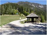
From the parking lot, we walk to the nearby pass, from there we continue right in the direction of the peak Ojstrc / Hochobir (Ojstrc is the highest peak of Obir). The path at the very beginning leads past a pleasant rest area, then along the macadam road, from which a nice view opens up on the northern walls of Košuta, Setiče / Freiberg and more. Along the macadam road, which branches off from the main road at the pass Šajda, we walk to the signposts, which direct us right onto the path that starts ascending through the forest. The path, which subsequently crosses the macadam road 8 times, ascends mostly through the forest most of the time, but there are enough clearings, grassy slopes, and sparse forest in between, from where a nice view opens up mainly toward the south and west. When we finally leave the road, we ascend wooden steps, then from the forest we arrive at a larger meadow, where on the right we notice Kacmun's cross.
At Kacmun's cross, the path first turns left and leads us past the entrance to the tunnel. After the tunnel, straight ahead continues the steep path to Kravji vrh / Kuhberg (across the meadow pathless), while we continue on the marked path, which turns right into the forest. The mostly spruce forest starts to thin after a few minutes, then the path over the pasture fence brings us to panoramic and increasingly grassy slopes. The path continues along an indistinct grassy valley toward Obirsko sedlo / Obirsattel. A few steps before reaching the saddle, the marked path turns right (to the left branches an unmarked path to Kravji vrh / Kuhberg).
Further on, we ascend gently to moderately along the summit slope of Obir, from where beautiful views open up. A little further, the path temporarily becomes completely flat and bypasses the ruins of the former Rainer shelter / Rainer Schutzhaus on the left side. A little further, we join the path from Kapelska koča / Eisenkappler Hütte. Here we continue straight and along and beside the increasingly panoramic ridge, which is especially dangerous for slipping in snow, we ascend to the 2139 m high peak.

Photos:
 1
1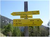 2
2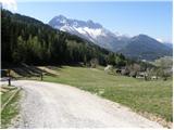 3
3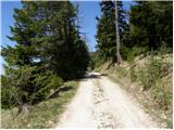 4
4 5
5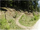 6
6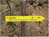 7
7 8
8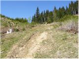 9
9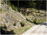 10
10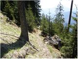 11
11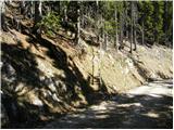 12
12 13
13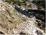 14
14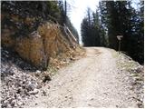 15
15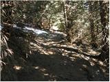 16
16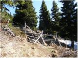 17
17 18
18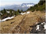 19
19 20
20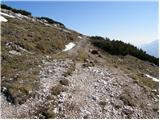 21
21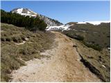 22
22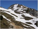 23
23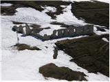 24
24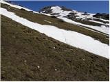 25
25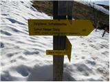 26
26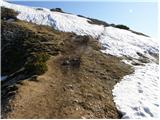 27
27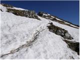 28
28 29
29
Discussion about the trip Šajda / Schaidasattel - Hochobir (Ojstrc)
|
| izigov5. 10. 2009 |
Yesterday's hike.
Weather great with wind on top.
Regards from Carinthia
|
|
|
|
| aonuk16. 10. 2009 |
Where does so much snow on the summit come from?
|
|
|
|
| izigov6. 10. 2009 |
These old pics - no snow now.
Regards from Carinthia
|
|
|
|
| izigov6. 10. 2009 |
On the upper link fresh pics from Sunday..
|
|
|
|
| kolosej1. 11. 2011 |
Along the described route to Ojstrc, for two-thousanders collectors there is Kravji vrh - 2017m, which is marked as 2024m on the PZS Karavanke 1:50000 map. The summit is completely overgrown with dwarf pines, so you need to find a passage in the western part of the ridge, follow the labyrinth of cut dwarf pines which easily leads to the top where there is a nice cross with a bilingual inscription and a summit logbook.
|
|
|
|
| kitina21. 05. 2012 |
On Saturday I was up there. Nice path with nice views. Weather sunny with some wind. Regards.
|
|
|
|
| malovrh48. 07. 2012 |
Yesterday evening I made the ascent on the described path. Wonderful. Almost to the summit I didn't meet anyone, but on the summit more than 50 hikers. I would just add that the access to the starting point from central Slovenia is significantly faster via Ljubelj than via Jezersko (by more than 40 min)
lp
|
|
|
|
| PAJKEC30. 10. 2013 |
Conquered the summit on Saturday. Beautiful tour, very nicely routed path, not strenuous and with wonderful views. Regarding access to Šajda, I agree with the previous commenter that the closest is via Ljubelj, but I would add that it's even closer if we keep right in Borovlje towards Zell-Pfarre, because the path described above goes quite a detour. Alternatively, we can make a loop and also see the beautiful Podjuno valley and Borovniško jezero.
|
|
|
|
| zajko4. 08. 2014 |
Yesterday from Šajda to Obir, back along the ridge (very nice panoramic path) to Kravji vrh and descent to the valley. Descent to the junction with the marked path is very steep. Otherwise a very nice excursion. As for car driving, same length via Ljubelj or via Jezersko.
|
|
|
|
| ljubitelj gora11. 11. 2018 |
On this described path to the top of Obir, some fallen trees on the hiking trail, otherwise the path is fine and easy.
|
|
|
|
| michael6616. 08. 2019 |
Does anyone know how to most easily visit Kravji vrh on the way from Šajda saddle to Obir?
|
|
|
|
| sh16. 08. 2019 |
A while ago we hiked the mentioned trail, first from Šajda to the top of Obir and on the return via Kravji vrh. The trail is clearly visible.
|
|
|
|
| J.P.9. 10. 2022 16:25:48 |
Driving by car is time-wise shorter via Ljubelj as it covers a larger section of motorway. (if coming from Lj e.g.) Ojstrc, Kravji vrh and no name peak in between (maybe it has a name?!) are exceptionally panoramic peaks. Among the most beautiful. Ojstrc otherwise crowded but not from Šajda direction. Highly recommended.
|
|
|
To post a comment you must log in:
If you do not yet have a username, you must first
register.