Zavrate - Baba (above Rečica)
Starting point: Zavrate (552 m)
| Latitude/Longitude: | 46,1611°N 15,1522°E |
| |
Walking time: 40 min
Difficulty: partly demanding marked way
Elevation gain: 237 m
Elevation difference along the route: 237 m
Map: Posavsko hribovje - zahodni del 1:50.000
Recommended equipment (summer):
Recommended equipment (winter): ice axe, crampons
Views: 13.322
 | 3 people like this post |
Access to starting point:
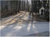
a) We drive into Laško, and then at the traffic light intersection we drive in the direction of Spodnja Rečica. Further on, Laško ends and we arrive at Spodnja Rečica, and later also at Zgornja Rečica, but we continue driving. When the main road turns right towards Šmohor, we go slightly left onto a side road, along which there are signs for Brezno. For a short time, we continue driving through the valley, and then the road turns sharply to the left and crosses onto the northern slopes of Baba, through which we ascend diagonally past individual homesteads. When we return to the forest, we quickly reach the Zavrate saddle, where we park in a suitable place. At the starting point, there is the log cabin Brunarica pri knapu below Baba and one of the entrances to the former Barbara rov mine.
b) From the Hrastnik - Rimske Toplice road, we turn left (or right from the direction of Rimske Toplice) towards the settlements of Sedraž and Trnovo. At the next intersection, we go slightly left towards Brezno, and then we start noticeably ascending towards the Zavrate saddle. When we reach the mentioned saddle, we park in a suitable place.
Route description:
From the Zavrate saddle, we head west on a footpath towards Baba and Ostri vrh (east of the saddle, a path leads to Govško brdo). The path at first leads past a log cabin "Pri knapu pod Babo", and then continues on at first a gentle cart track. After a few minutes of easy walking, we notice a signpost directing us left onto a well-trodden footpath that begins to ascend more steeply. Higher up, the path becomes so steep that fixed safety gear is available for assistance, though not necessary in dry conditions (in wet or snowy conditions, there is a significant risk of slipping). We then follow this quite steep and well-maintained path to the peak of Baba, from where a beautiful view opens up.
Photos:
 1
1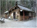 2
2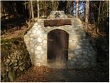 3
3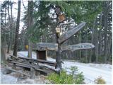 4
4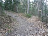 5
5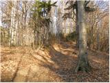 6
6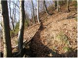 7
7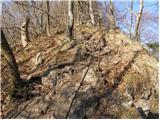 8
8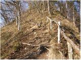 9
9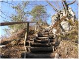 10
10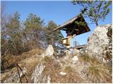 11
11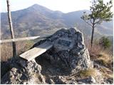 12
12
Discussion about the trip Zavrate - Baba (above Rečica)
|
| VanSims17. 04. 2010 |
I think this trail could easily be marked as easy. It's not that steep. The scrambling is only in the last 5-10 min. Maybe this trail is suitable for a beginner who wants to get to know scrambling in a friendly way! Maybe needed only downhill.
|
|
|
|
| grega_p11. 05. 2010 |
In wet conditions, things can be slippery downhill, otherwise the path is not difficult and is suitable for a nice half-day hike. If that's not enough, continue to Ostr vrh (another half hour).
Video of today's panorama from Baba:
http://www.youtube.com/watch?v=avfVLSvWbPk
If anyone is interested: On 26.5., hikers from PD Laško are organizing a hike from Huda jama (Rečica) to Šmohor, Gozdnik, Mrzlica, Ostr vrh and Baba (info from a local)
|
|
|
|
| EUGEN12. 05. 2010 |
You can continue:
Kal, Mrzlica, Goznik, Šmohor, Rečica, Zavrate.
Laško, Govško brdo, Zavrate, Baba, Ostr vrh,
Kal, Mrzlica, Goznik, Šmohor, Malič, Laško.
|
|
|
|
| minka8. 03. 2011 |
I'm interested in the length of the path Zgornja Rečica-Baba-Ostri vrh-Kal and if it's well marked.
thanks for the reply
|
|
|
|
| marchy8. 03. 2011 |
Minka, don't worry, the path is very well marked. There's also enough space to park at the hut, but the road from Sp. Rečica to Zg. Rečica is very narrow and quite steep towards the Zavrate pass, careful driving is needed. (when driving past Plečnik's church in Zg. Rečica, keep to the left). From the hut at Knap you have about 45 min to Vrh Baba, then descend along the ridge down and up to Ostr vrh, that's less than half an hour. I haven't been to Kal, maybe I'll do that tour this year. Enjoy and safe steps, marchy
|
|
|
|
| ansev12324. 06. 2019 |
Great path. I wouldn't quite agree that it's a partially difficult path.
|
|
|
|
| taubi6624. 06. 2024 10:42:23 |
Unfortunately, this pillar with the logbook is collapsed. In the box with the book, there's an anthill.
|
|
|
To post a comment you must log in:
If you do not yet have a username, you must first
register.