Zavetišče na planini Šija - Veliki vrh (Košuta) (Kačja pot)
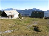
Starting point: Zavetišče na planini Šija (1528 m)
| Latitude/Longitude: | 46,4248°N 14,3354°E |
| |
Route name: Kačja pot
Walking time: 2 h
Difficulty: easy unmarked way
Elevation gain: 560 m
Elevation difference along the route: 650 m
Map: Karavanke - osrednji del 1:50.000
Recommended equipment (summer):
Recommended equipment (winter): ice axe, crampons
Views: 39.491
 | 6 people like this post |
Access to starting point:
From the Ljubljana–Jesenice highway, we take the Ljubelj exit. Then we drive to the center of Tržič and follow the road through the Dolžanovo gorge to the village Jelendol, where signs for the mountain pastures Kofce, Šija and Pungrat direct us to the left. The road then loses the asphalt surface and starts to ascend steeply. We follow this road at the crossroads in the direction of the mountain pastures Pungrat and Šija. We park on the parking lot near the shelter on the mountain pasture Šija.
Route description:
A little north of the shelter we notice a wooden mountain sign with the inscription "kačja pot na froncov greben" (the mountain path is found a little more to the right of the direction indicated by the sign). The path ahead crosses a grazing fence and brings us out of the forest to a smaller scree. After this scree the path crosses a shorter belt of spruce forest and then brings us to avalanche slopes, where the path turns a little to the left. Further in a gentle ascent we cross a grassy slope, a belt of dwarf pines and a larger scree after which we come to a belt of shrubs (dwarf pines and individual trees). Here the path starts to ascend steeply and quickly brings us below the rocky cliffs. We cross a narrow passage (watch your head) and the steep path then brings us to the place where we join the marked path that comes from the Dom na Kofcah hut.
We continue right upward along the path, which ascends steeply and quickly brings us to an exposed passage. Without fixed protection we cross a short but crumbly and slightly exposed ledge after which we enter a belt of dwarf pines. The path ahead ascends through a short belt of dwarf pines, then continues along the side ridge of Košuta. An increasingly scenic and quite steep path joins the ridge path higher up.
We continue left toward Veliki vrh (right Kladivo, straight upward Kofce gora 10 steps) along the path, which starts to descend slightly along the edge of the ridge. The path, which crosses the slopes of Košuta toward the west, joins the usual path to Veliki vrh (descent option) after about 15 minutes of walking, where we enter a smaller indistinct valley. The path then from the valley again moves onto the southern slopes, where it bypasses the peak »Toplar (2000m)« on the south side and brings us below the summit slope of Veliki vrh. The path, which for some time ran along the ridge, here withdraws from it and continues in a traversing ascent on the shady slopes. Higher the path turns sharply right and then in a few minutes brings us to the scenic summit.
Starting point - Kofce gora 1:15, Kofce gora - Veliki vrh 45 minutes.

Photos:
 1
1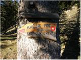 2
2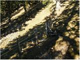 3
3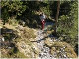 4
4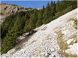 5
5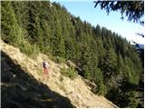 6
6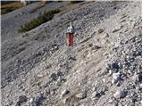 7
7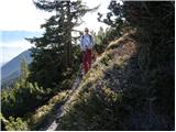 8
8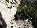 9
9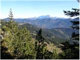 10
10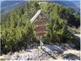 11
11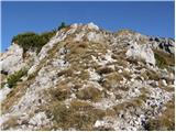 12
12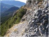 13
13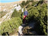 14
14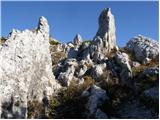 15
15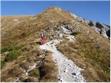 16
16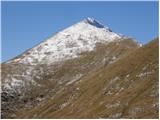 17
17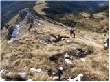 18
18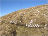 19
19 20
20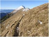 21
21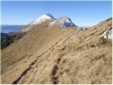 22
22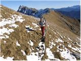 23
23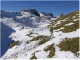 24
24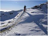 25
25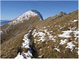 26
26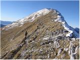 27
27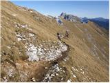 28
28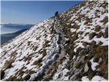 29
29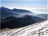 30
30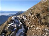 31
31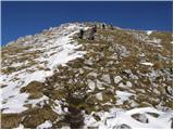 32
32 33
33
Discussion about the trip Zavetišče na planini Šija - Veliki vrh (Košuta) (Kačja pot)
|
| Damijan13. 05. 2007 |
Excellent tour. The area around Košuta really appeals to me because of the grass that surrounds the entire range and makes these mountains even more beautiful. Truly wonderful and nice view.
|
|
|
|
| Gost23. 09. 2007 |
You can also nicely reach it from Kofce, nice trip also for family, as long as not too out of shape. The summit is not to be underestimated, just like nowhere else in the mountains. Phenomenal view of all other mountains from Kamnik to Julian Alps and view straight down into Austria...
|
|
|
|
| katty18. 09. 2011 |
Yesterday went with a colleague from the gravel road, which is quite hard to drive in places due to big hills, to Kofce, Veliki vrh and Kofce gora. On the way from planina Šija to Kofce we arrived at a stable lower than planina Šija. Yesterday they were driving cattle down from the pastures, mid-September and that's completely normal. Anyway, at Dom na Kofcah lots of people, mainly retirees. They go collecting stamps for certain benefits they get in sports equipment stores, there were many diabetics too. Anyway, weather ideal up to mid-ascent, then mists swirled above us, cold and moderate wind appeared. So no short sleeves on the top. Stamped the booklet and quickly went to Kofce gora. Due to mists no views, so quickly to Kofce, which around 13:30 were packed full. To sum up, if no fog and wind, it would have been really pleasant weather. Happy I used the nice weather again and went to the mountains.
|
|
|
|
| vespuci21. 09. 2011 |
katty, I didn't understand you at all. Did you drive to Kofc or to Šija? I'm interested because tomorrow I'm heading to those parts and my starting point will be planina Šija
|
|
|
|
| katty21. 09. 2011 |
Hey. Actually, we drove on the gravel road for a while, then parked even lower down from that junction where you can go right by car towards Šija, left towards Kofce. We walked a few more minutes to a small hut on the left side when driving uphill, opposite it there is a large parking lot. But the road is quite rutted in some places, quite high bumps appear. If you have an off-roader, it is no problem at all. For any info, send me a PM.
|
|
|
|
| alesfon19. 05. 2020 |
Hello,
I am interested in the conditions on this path and access to planina Šija.
Thanks. Regards
|
|
|
|
| ovi3. 06. 2024 15:58:37 |
for info: road to planina Pungrat is passable for all vehicles - was there yesterday with Clio - slowly. The worst part of the road is from the end of asphalt 10 hairpin turns uphill (sometimes road undercut; from Punrat to Šija there are critical 50 m from the pasture fence and the bend at the watering place behind the end of the fence - cow barriers - rollers - soft fill - further ok.) - if you must - it goes with any vehicle.
And the štruklji at Taborniški dom are excellent!
Oh - unmarked path from Šija to planina Kofce /Veliko Kladivo - Veliki vrh/ is partially poorly visible, just before we finish crossing the scree (up from Šija) a landslide has taken part of the scree and you need to be CAREFUL! (or end up 100 m lower in the gully);
Immediately after joining the "usual" - steep path from Kofc (Veliko Kladivo) to Kofce gora, winter has also "done" the exposed part and you can admire the void under your feet (under the overhanging rock) - through some roots of bushes - wife went on 4 rih (previously on Jalovec etc.); careful - PZS INSPECTION NEEDED!
Be careful and safe steps!
https://photos.app.goo.gl/JnxbbWTPRdzDriJXA
|
|
|
To post a comment you must log in:
If you do not yet have a username, you must first
register.