Zajzera - Viš/Jof Fuart (Gola Nordest)
Starting point: Zajzera (897 m)
Route name: Gola Nordest
Walking time: 6 h
Difficulty: extremely difficult marked way
Elevation gain: 1769 m
Elevation difference along the route: 1769 m
Map: Julijske Alpe - zahodni del 1:50.000
Recommended equipment (summer): helmet, self belay set, ice axe, crampons
Recommended equipment (winter): helmet, self belay set, ice axe, crampons
Views: 43.126
 | 4 people like this post |
Access to starting point:
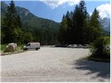
Via the border crossing Predel or Rateče, drive to Trbiž / Tarvisio. Further, drive on the old road towards Videm / Udine. Already after a few kilometers from Trbiž / Tarvisio, the road into Ovčja vas / Valbruna branches off to the left. In Ovčja vas / Valbruna, turn left and follow the road ahead through the Zajzera valley upwards. After a few kilometers of driving, come to a junction at the bridge above the road (at the second bridge). Here, turn left in the direction of the signs for Svete Višarje / Monte Lussari and then already after a few meters of driving, turn right onto the large parking lot where you park.
Route description:
At the end of the parking lot, head onto the cart track, which after a few tens of meters joins the road. Continue left over the bridge and follow the road to a junction where you turn right following the signs »616 Rifugio Pellarini«. For some time then walk along the river and soon join the mountain road. Continue left on the mountain road, along which you then ascend for a long time. All the time while walking on the road, follow the signs for path 616 and hut Rifugio Pellarini.
At approximately half of the ascent on the road, a very demanding path to Mali Nabojs (Piccolo Nabois) branches off to the right. Continue on the road all the way to the end, where there is the lower station of the cargo cableway. Continue slightly right onto the cart track, which quickly turns into a trail. The path then turns left and starts ascending on a somewhat steeper slope below the cableway. Ascend mostly through the forest towards the east, occasionally with a nice view opening up on the surrounding peaks. Such a path leads to a marked junction where you continue right following the signs Rif. Pellarini (20 min), while left leads path 617 to Svete Višarje (4 hours).
The path soon leads out of the forest onto scree, from where a very nice view opens up towards Viš. Here the path turns right and follows the last ascent to hut Pellarini.
From the hut, continue on path 616, which after a few tens of meters leads to a junction. Continue right following the signs Sella Nabois (Škrbina Nabojsa), while left leads the path towards Žabniška škrbina (Sella Carnizza). The path then leads across the wide bed of a torrent to the right side of the valley, where you soon reach a new junction. Continue straight following the signs Grande Nabois via normale, while right leads the ridge path to Veliki Nabojs.
Continue ascending on the right side of the valley past increasingly sparse dwarf pines and larches. The path then leads to yet another junction where the inscription on the rock »NE Gola« directs left, while right the path continues towards Škrbina Nabojsa.
Red dots then lead across the scree towards the northeastern gully of Viš, which is visible from afar. In the lower part, the gully is divided into two parts. Head towards the right and ascend the scree beside the snowfield upwards. Snow usually persists here throughout the year, so appropriate winter equipment is needed. Further on the path, the use of a helmet and self-belaying is mandatory. Cross the snowfield towards the well-visible ledge in the wall of Mali Viš (that's the name of the rocky spur that divides the gully into two parts). The path along the somewhat exposed ledge then leads to the eastern side of Mali Viš, turns right, and leads to the start of the climbing section of the path. Here, ascend with the aid of a steel cable up a very steep gully. In the upper part, climb out of the gully to the left side and continue steeply ascending along the steel cable for a while. Climbing on this section is very demanding; also consider that the distances between the bolts to which the steel cable is attached are very large, meaning that a fall despite self-belaying is quite dangerous. Further, the somewhat less demanding path turns right and along the ridge leads to the entrance into the gully. Through the gully, ascend over numerous rocks and boulders. On a few harder sections, a steel cable assists. The hardest is the ascent through the high chimney, which in the upper part is also slightly overhanging. The ascent through the chimney is otherwise well protected with a steel cable, assisted also by a few bolts. Further, the path soon turns left and then ascends up the left side of the gully. On this section of the path, considerable caution is needed, as the path is secured only at rare spots. In the upper part, the path turns right and along the narrow ledge with the help of a few steel cables leads out of the gully onto the grassy slope called Božje police.
For a short time, still cross the grassy slope, then the path turns left and ascends very steeply up the unsecured gully. After climbing the steep gully, which otherwise has plenty of good holds that facilitate climbing, reach somewhat less steep slopes on the eastern side of Viš.
Further, the path turns slightly right and ascends the slope, which is somewhat less steep but due to the unmaintained path and scree quite dangerous for slipping. When approaching the southeast ridge along which the normal path to Viš leads, the path turns somewhat right and with the help of a few steel cables ascends towards a smaller notch from which a view opens to the northwest. At the notch, turn left and follow the crossing along the narrow ledge to the junction where you join the normal path to Viš.
Here, continue right and only a few minutes of less demanding ascent remain to the very panoramic summit.
For the descent, it is most recommended to organize transport from Nevejski preval and descend past hut Corsi into the valley.
If you must return to the same starting point, all paths are considerably more demanding and longer. The shortest but also most demanding in this case is descent via the ascent path.
Another option is to choose path Anita Goitan to Trbiška škrbinica. From Trbiška škrbinica, do not descend into the gully, which is closed and extremely dangerous (marked with »NO«), but continue ahead on the marked path and follow the signs »R. Pellarini«.
You can also descend to the starting point via Škrbina prednje Špranje and bivouac Mazzeni.

Photos:
 1
1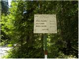 2
2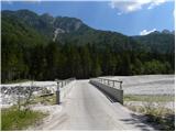 3
3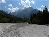 4
4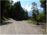 5
5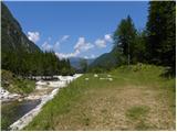 6
6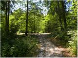 7
7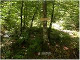 8
8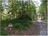 9
9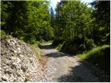 10
10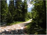 11
11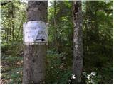 12
12 13
13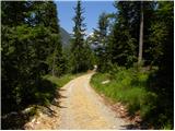 14
14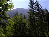 15
15 16
16 17
17 18
18 19
19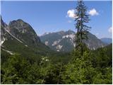 20
20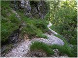 21
21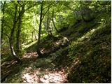 22
22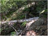 23
23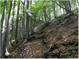 24
24 25
25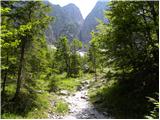 26
26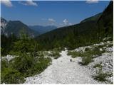 27
27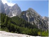 28
28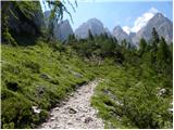 29
29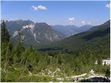 30
30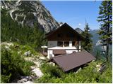 31
31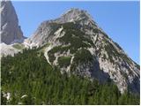 32
32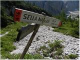 33
33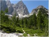 34
34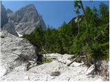 35
35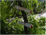 36
36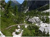 37
37 38
38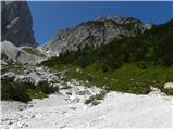 39
39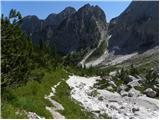 40
40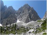 41
41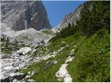 42
42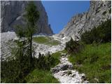 43
43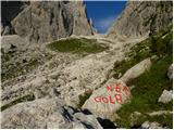 44
44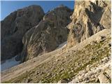 45
45 46
46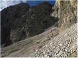 47
47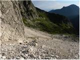 48
48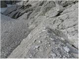 49
49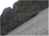 50
50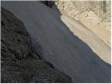 51
51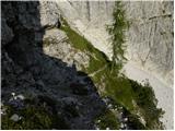 52
52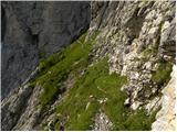 53
53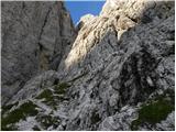 54
54 55
55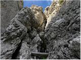 56
56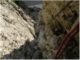 57
57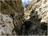 58
58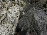 59
59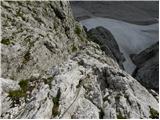 60
60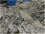 61
61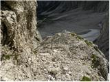 62
62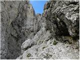 63
63 64
64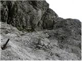 65
65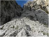 66
66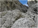 67
67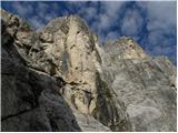 68
68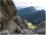 69
69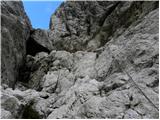 70
70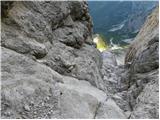 71
71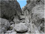 72
72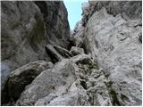 73
73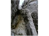 74
74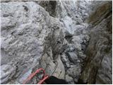 75
75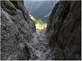 76
76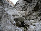 77
77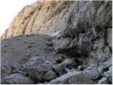 78
78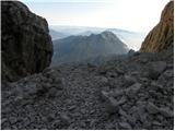 79
79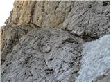 80
80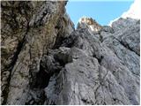 81
81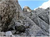 82
82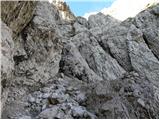 83
83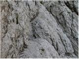 84
84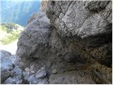 85
85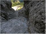 86
86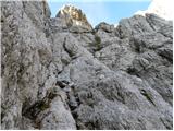 87
87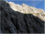 88
88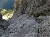 89
89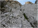 90
90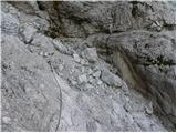 91
91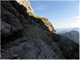 92
92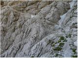 93
93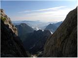 94
94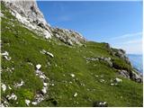 95
95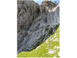 96
96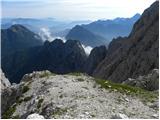 97
97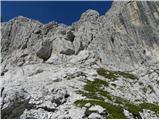 98
98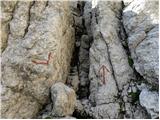 99
99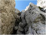 100
100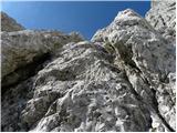 101
101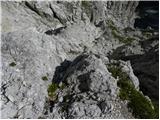 102
102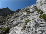 103
103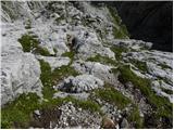 104
104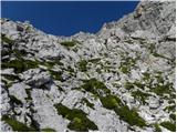 105
105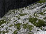 106
106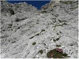 107
107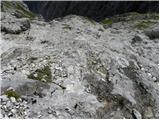 108
108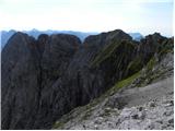 109
109 110
110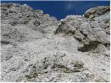 111
111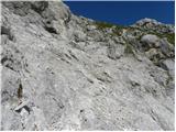 112
112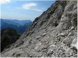 113
113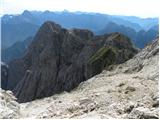 114
114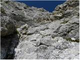 115
115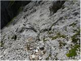 116
116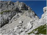 117
117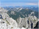 118
118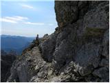 119
119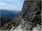 120
120 121
121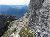 122
122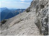 123
123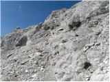 124
124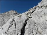 125
125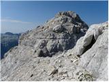 126
126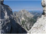 127
127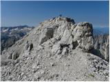 128
128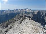 129
129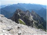 130
130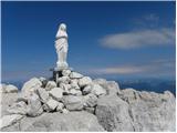 131
131
Discussion about the trip Zajzera - Viš/Jof Fuart (Gola Nordest)
|
| skrajnik18. 08. 2011 |
Is it possible to shorten the path to Rifugio Pellarini with some access via a forest path?
|
|
|
|
| dprapr19. 08. 2011 |
As far as I remember - it's been many years - I drove further towards Zajzera and then parked at a small parking lot in the forest on the other side of the stream. From there first on gravel road and later on path to the hut. I think it was about an hour's walk to the hut.
|
|
|
|
| LidijaJesih20. 08. 2011 |
Skrajnik, did you go check? Were you at the top? Path otherwise ok? Nice day, even if you weren't
|
|
|
|
| skrajnik20. 08. 2011 |
Yes, we checked it live..
Can't shorten the approach, except with a jeep to the cable car...
Via ferrata otherwise super, path from the early discoveries of Viš - natural passages, lots of free climbing, secured only on necessary parts.. Objectively/relatively dangerous in a few parts (holes in the glacier, rocks, scree..) Visit in my opinion rare.
At the top unfortunately only partially clear, so view not 100%.
Returned via Anito Gotian back to the hut and start, already in the dark, like 3 rags. Path partly in clouds.
Beautiful and infinitely loooong tour.
"Walk or die" 
|
|
|
|
| LidijaJesih20. 08. 2011 |
Sounds good . How does Trbiška škrbina look, still any snow (last time I was scrambling there)? this walk or die today already forgotten, as it seems to me. . How does Trbiška škrbina look, still any snow (last time I was scrambling there)? this walk or die today already forgotten, as it seems to me.
|
|
|
|
| skrajnik20. 08. 2011 |
No snow in the notch, where there is, it can be bypassed. Problem only at the entry, but it's sprinkled with sand. It's quite hard and doesn't give much.
Walk or die is a joke from the tour, because we wanted to be in the valley by dark, already destroyed
|
|
|
|
| LidijaJesih20. 08. 2011 |
Thanks, one more thing: how long did the round take, if no secret?
|
|
|
|
| IgorZlodej20. 08. 2011 |
The road to the cable car is of course closed to public traffic, so even an off-roader is out of the question . But I don't get why descend via A.G. and over two notches, when you can comfortably descend to Jezersko valley (of course with pre-arranged transport), or simply down to koča Corsi, then under Kapna stena to Škrbina prednje Špranje and down to Zajzero, or just to Špranjo and over Nabojsova škrbina via path C. Cersi to Pellarini and back to the valley. . But I don't get why descend via A.G. and over two notches, when you can comfortably descend to Jezersko valley (of course with pre-arranged transport), or simply down to koča Corsi, then under Kapna stena to Škrbina prednje Špranje and down to Zajzero, or just to Špranjo and over Nabojsova škrbina via path C. Cersi to Pellarini and back to the valley.
|
|
|
|
| ajo6210. 10. 2011 |
I think Skrajnik descended via the best variant: the Goitan path is great, among other things it has the least elevation loss in this direction, only the descent on scree via the newer marked path to the right (on descent) from Trbiska skrbina is a bit ugly. The variants via the front Spranja (Lavinal) are longer - especially the one via Nabojsova Skrbina (from the junction at Mazzeni you have to climb back up about 400m... I don't know if Igor took that variant, I have done all three options to the parking lot in Zajzera and it seems to me that Skrajnik did right - probably rested quite a bit in 14 hours... that's also a pleasure... best regards
|
|
|
|
| LidijaJesih10. 10. 2011 |
Ajo62, I think you're right. Under Viš - current conditions is my description from Thursday, I was thinking the same on the way as you write. Mainly you lose (and then regain) elevation, even without Nabojsova škrbina, the path is a bit more time-consuming because you go past Pellarini, and also through Škrbina prednje špranje it goes quite slowly (descent is very ugly). For the loop I took 10.5 hours, without any special rushing.
|
|
|
|
| IgorZlodej10. 10. 2011 |
@ajo62 writes: I don't know if Igor took that variant.
He did, and not just once, but multiple times in all directions, and also skied from all the notches. Otherwise I'm always surprised that those who were there only once know the most.
|
|
|
|
| ajo6213. 10. 2011 |
dear Igor, we won't argue among ourselves, as we are all mountain lovers.. to be honest I too have been to Viš at least 15 times in the last 25 years via various paths and routes. I was lucky to overnight several times in Corsi when Raimondo Sciarillo was still managing the hut (I think you knew him) from the famous Triestine alpinistic school E. Comici. I talked to him several times about these !"variants" as he was practically at home there. He was simple and modest, from him I learned a lot.. Best to all!
|
|
|
|
| rant26. 08. 2012 |
Red secured path is the current direction. The blue-marked path is in very poor condition, made when the glacier was about several tens of meters higher.
|
|
|
|
| pirseb2414. 05. 2013 |
Good day
I would ask gentlemen Igor and alo62 given that you have a lot of experience which path you recommend for Viš or which is less demanding Goitan or centenary path
In some guide the centenary path is marked with rating 2 which should mean easy path but from pictures and description it's not exactly easy.
Please if you can advise which path would be suitable for a beginner for ascent to Viš
Thank you for every answer and advice
Best regards
|
|
|
|
| klm14. 05. 2013 |
I'm not Igor (Zlodej) nor alo62 (correctly ajo62), but I allowed myself to answer the question anyway: The above described NE couloir has been neglected for some years and therefore requires an even more experienced mountaineer. A. Goitan does not lead directly to the summit of Viš but crosses it halfway, or rather the entire central group from Koštrun peaks of Viš, Divja koza Turn and Gamsova mati. The easiest approach leads from Rifugio Corsi http://www.hribi.net/izlet/nevejski_preval_vis_jof_fuart_/1/1041/1738
The centenary path practically has no connection with Viš. If you want to connect it with ascent to Viš, you need to be in quite good physical condition. Technically it's not so demanding.
|
|
|
|
| IgorZlodej14. 05. 2013 |
I assume the path to koča Corsi is already known, if not, I suggest from the monument in Jezerska dolina via Viška planina to the hut and then to Škrbina zadnje Špranje (Forc. Mose) and to the summit, descent through the preduh, of course at this time and sometimes even in early summer you have to reckon with snow patches, so set out with appropriate equipment.
|
|
|
|
| urbancek19. 07. 2013 |
In the latest issue of Planinski vestnik (p. 44) it says that the path to Viš through the northeast couloir is today well secured and maintained... Isn't it abandoned and damaged for years?? If the magazine provided wrong information, that seems a bit  for a magazine with such tradition... for a magazine with such tradition...
|
|
|
|
| IgorZlodej19. 07. 2013 |
It was partially repaired a few years ago, specifically safety gear was installed on the slimy passage across the rock jump, but last year there was also a small rockfall in the gully, so the path is by no means easy. The description in PV also surprised me a bit
|
|
|
|
| Daaam19. 07. 2013 |
If we were a bit picky, we could say that the forum provides more reliable data than professional literature 
|
|
|
|
| klm19. 07. 2013 |
To tell the truth, most PV writers "sit" on hribi.net, then nicely copy. The magazine is... I'd rather not criticize.
Anyway: on the forum you can write once, twice, three times and correct, but not in the magazine.
|
|
|
|
| miri19. 07. 2013 |
@kim, I wouldn't claim that about PV writers. Just Goriška as an example, so I don't list the others.
|
|
|
|
| klm19. 07. 2013 |
My intention was not to provoke a debate but to highlight individual PV writers who are reliable or not, since ultimately it's the editorial board and the editor himself who should verify or know the facts.
|
|
|
|
| darinka423. 05. 2015 |
I'm interested if anyone went to Viš last year via Gola Nordest path. A few years ago, when my colleague and I went, the cable was damaged and we had to somehow get through. Otherwise it's a very demanding tour, you hardly meet anyone. In the gully the markers were poorly visible, there we found a path that goes up the gully. How are the fixed protections today?
|
|
|
|
| matic46. 07. 2015 |
In the gully some cables are torn, the path is barely passable. There are few marks and they are faded. Cairns and carved footsteps help us. For descent we would probably need a rope. There's still snow in the gully now, so we need ice axe and crampons. On the path over Trbiška škrbina the marks and cables are renewed.
|
|
|
|
| redbull7. 07. 2015 |
last summer it was fine, unless this winter changed something. The path is well visible anyway, so you don't need marks
good luck
|
|
|
|
| ljubitelj gora22. 07. 2017 |
Winter gear is no longer needed, went up today 22.7
|
|
|
|
| ljubitelj gora23. 07. 2017 |
....there are many sections of free climbing, without the aid of protections. Markings have faded. The path is extremely beautiful.
|
|
|
|
| Lotka20. 08. 2017 |
Hello, I walked this path, nice. I'm interested in a comparison with via amalia on montaz.
Thanks
|
|
|
|
| dprapr20. 08. 2017 |
Via Amalia is longer. But up to bivouac Suringar it's very well secured.
|
|
|
|
| Lotka20. 08. 2017 |
What about further on? Is there more free climbing than on nord est? Is it technically more demanding? Namely, as long as there are protections it's all ok, when they run out, it's not the easiest for me anymore 
|
|
|
|
| ben20. 08. 2017 |
Further on is the Findenegg glacier, marked and secured, climbing section II degree!!
|
|
|
|
| dprapr20. 08. 2017 |
The Findenegg glacier is already well trodden, dangerous mainly due to falling rocks if someone is above you.
II degree? Where?
|
|
|
|
| dprapr20. 08. 2017 |
For me there's no "stroll" anywhere.
On all paths and off-paths caution is important, accidents happen precisely where it's "easy".
If the description says so, then it holds. Maybe the step in picture 77 on your link.
|
|
|
|
| jax20. 08. 2017 |
Most likely right there. However, it is possible to pass through the chimney itself, which probably does not reach grade II, but it is very awkward to squeeze through with a backpack. Most hikers therefore prefer to go left along the ledge there, where there might actually be a grade II.
Anyway, climbing grades are exaggerated anyway. Grade II is climbed in many places on marked trails, where people would not even think of calling it climbing.
|
|
|
|
| coffee20. 08. 2017 |
I don't want to get into a debate about grades either, so just in passing, Mašer in the guidebook on the Western Julian Alps marks two jumps in the couloir with II.
|
|
|
|
| Lotka20. 08. 2017 |
Thank you for the answers. So, if I have climbed Gola nord est, arrived at the altar, I hope this will work too.
|
|
|
|
| Gorska planika16. 07. 2018 |
Hello! Has anyone walked this path recently? What's the condition of the path? Thanks
|
|
|
|
| redbull17. 07. 2018 |
If you don't get an answer from anyone, I can tell you that in the lower part you definitely need to cross the snowfield to the start of the wall. Ice axe, crampons are quite necessary, although we have already gone through without them.
Good luck
|
|
|
|
| VIŠMAN17. 09. 2018 |
Hello
The path to Viš via NE couloir (GOLA NORD EAST) was on 16.9.2018 completely normally passable and excellently secured. The snowfield can be bypassed without problems on the left side, so winter gear can stay at home.
Pelarini and Corsi were open. The path is incredibly beautiful with aids only where really needed.
|
|
|
|
| dprapr16. 07. 2019 |
https://www.hribi.net/trenutnerazmere.asp?slo=1&gorovjeid=1&id=8003
Below Božje police there is certainly still some small snowfield in the scree. We didn't use gear, but at a few spots quite some ingenuity was needed to proceed.
At the entry there was scree on the snowfield and no problems.
In the upper part, below the ridge, that snowfield should have melted by now.
|
|
|
|
| Višarski5. 09. 2021 00:02:52 |
Today via the NE couloir to Vis. The problem is the hard snowfield at the bottom by the entrance, partially covered with scree. You need crampons and an ice axe, ideally two ice axes. Stones fly here non-stop (one hit me nicely on the helmet). The ledge marked with a red dot, where you have to go down from the snowfield to the rock, is accessible only when you descend approximately two to three meters quite vertically from the snowfield. That wouldn't be a problem if a deep chasm didn't gape right below. Then a long, magnificent, super ascent (the fixed gear, where present, is in good condition) to St. Mary, which faces Slovenia.
|
|
|
To post a comment you must log in:
If you do not yet have a username, you must first
register.