Žagana peč - Kalški greben (Hunting path)
Starting point: Žagana peč (812 m)
| Latitude/Longitude: | 46,3384°N 14,5702°E |
| |
Route name: Hunting path
Walking time: 4 h 10 min
Difficulty: very difficult unmarked way
Elevation gain: 1412 m
Elevation difference along the route: 1455 m
Map: Grintovci 1:25000
Recommended equipment (summer): helmet, self belay set
Recommended equipment (winter): helmet, self belay set, ice axe, crampons
Views: 16.985
 | 2 people like this post |
Access to starting point:
We drive into the valley of Kamniška Bistrica towards the Dom v Kamniški Bistrici. From the Dom, we continue forward on the road which soon becomes macadam. We follow the road ahead towards signs for Kokrsko sedlo. We park at the big boulder, Žagana peč, on which the altitude is also written. Some meters higher is on the left side of the road a smaller parking spot where we park.
Driving from the Koča v Kamniški Bistrici to Žagana peč is now forbidden (traffic sign), this extends the path for approximately 45 minutes.
Route description:
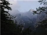
We start at Žagana peč, or half an hour lower at Kamniška Bistrica. Some meters above Žagana peč, where from Kamniška Bistrica lead blazes towards the saddle Kokrsko sedlo, on the left side of the road from parking space a well-beaten hunting footpath branches off. It rises through steep forest and crosses some gullies. We stick to the left direction and in a good hour we come to a small saddle, where there stands a hunting cottage with a bench (1330m). The path turns right above the cottage on the left slope of the hill and then on a natural groove. The footpath is all the time pretty steep and pleasantly soft. At the end of the groove a beaten path branches off to the right to Zob and ahead to Kalška gora and not to Čmaževski turn, which is lower. We follow the path straight, which starts vanishing in dwarf pines and is becoming less steep. The path almost completely avoids dwarf pines and completely vanishes on high mountain karst terrain of Kalce. If we follow the bottom of the indistinct valley (helped by cairns), we come to scree and via it to a marked path, which we follow to the right towards Kokrsko sedlo. Over a steep spot we get help from a steel cable. In 10 minutes we come to a crossing of paths, where we turn left towards Kalški greben. (Right Kalška gora and straight Kokrsko sedlo) We continue on the path which on places somewhat exposed ridge and with the help of some fixed safety gear brings us to the most difficult part of the path. The path brings us namely to a vertical wall, which we have to climb downwards. Helmet mandatory! The path is well secured and the use of self-belaying is also recommended. The steepness then slowly decreases and to the top there is still approximately 20 minutes of ascent on a panoramic ridge. Car-hunting cottage 1h10', hunting cottage-marked path 1h50', marked path-peak 1h10'.
The path is easy to the crossing under Kalška gora. Especially in fog, the orientation on high mountain karst terrain, despite cairns, is problematic. The path to the top is very demanding and partly exposed.

Photos:
 1
1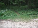 2
2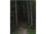 3
3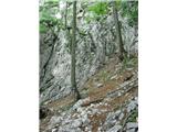 4
4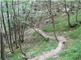 5
5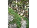 6
6 7
7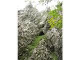 8
8 9
9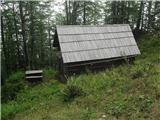 10
10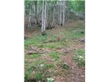 11
11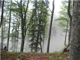 12
12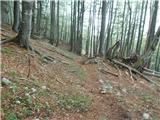 13
13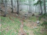 14
14 15
15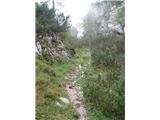 16
16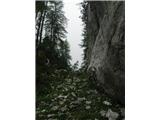 17
17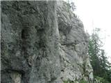 18
18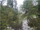 19
19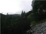 20
20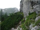 21
21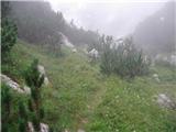 22
22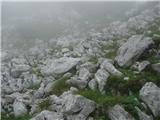 23
23 24
24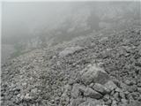 25
25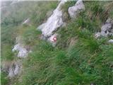 26
26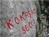 27
27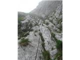 28
28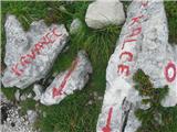 29
29 30
30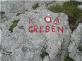 31
31 32
32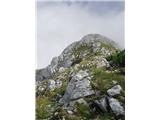 33
33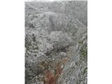 34
34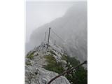 35
35 36
36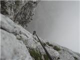 37
37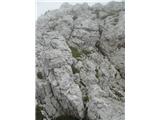 38
38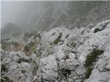 39
39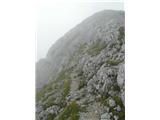 40
40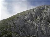 41
41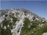 42
42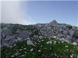 43
43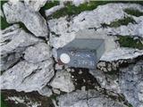 44
44
Discussion about the trip Žagana peč - Kalški greben (Hunting path)
|
| janez39. 09. 2008 |
The described path is called through Ovcarijo. When passing by the short steep wall, we are actually walking on a former alpine pasture.
At the end of the gully, a trodden path branches off to the right. (It would be hard to talk about any overgrowth here) And even that only for a short time. Further on, we have to look for the easiest passages with the help of cairns. It leads to Zob (it is correctly marked on the map) and over it to Kalška gora, or we can bypass Zob and go directly to Kalška gora.
Čmaževski turn is significantly lower and, according to my information, much harder to access.
|
|
|
|
| fpetel19. 09. 2008 |
I apologize for the misinformation. The junction is quite visible, although the path is already worse.
|
|
|
|
| garmont7. 06. 2011 |
The path described by f.petel leads to the summit of Kalški greben and not to Kalška gora, so the description is OK.
Lp
|
|
|
|
| fpetel17. 06. 2011 |
Yes, when I took these pictures I went to Kalški greben. Of course, it is also possible to go directly to Zob and the summit of Kalška gora and then continue along the same path as described to the top of K. grebena. Both unmarked variants are more orientationally demanding towards the summit (we follow predecessors and look for rare cairns, if we are not experts), because we can quickly stray into more difficult scree.
|
|
|
|
| janez37. 06. 2011 |
If my memory serves me right, my response was intended for the original entry, where there was a slight confusion around Zob and Čmaževski turn. This has now been corrected.
The path through Ovčarija, described by f.petel, is used by hikers both for ascent to Kalški greben and to Kalška gora or just for descent to Kokrško sedlo. When we arrive "from the indistinct valley through scree to the marked path", we can also continue briefly left and upwards in the direction of the entrance to the distinct Škrbina. We encounter old markings and broken fixed protection that lead us left of the notch towards Kalški Greben. This was the old marked path. Due to the scree and torn cables, all caution and experience are required.
|
|
|
|
| klm3. 09. 2011 |
currently the fixed protection is in perfect condition, along the path full of edelweiss, views magnificent, and best of all, no noisy "humans" (except very rare exceptions)  . Without doubt one of the (most) beautiful paths in Gintovci . Without doubt one of the (most) beautiful paths in Gintovci
|
|
|
|
| pohodnik3817. 06. 2012 |
On Saturday 16.6. I walked this tour first to Kalška gora then also Kalški greben nice solitary tour on unmarked path that occasionally gets lost a bit but if you know your way well in pathless terrain it's no problem at all....unforgettable.
VIDEO
|
|
|
|
| Klemenko23. 07. 2012 |
Yesterday, 22. 7. 2012, my friend and I also completed this ascent. To Kalška gora, then Kalški greben, then we decided to descend via Škrbina. You need to be quite attentive to turn left at the right time from the path to Vrh Korena, as the junction is not clearly marked, but you soon spot the markers.
Below Škrbina we wanted to shorten the return path, and also didn't want to climb back up (rain was brewing, which caught us later), so we searched for passages through the scree and eventually stumbled upon a (presumably hunting) path, which after quite demanding orientation decision-making finally connected us to the hunting path at the spot where we first see the ridge on ascent (a few meters above the wall right by the path).
Today I checked that our initial intuition was correct, although we didn't find the passage right away and continued much higher: From Škrbina you can head directly past Krvava lokva and keep towards the north (perhaps a step more easterly). You can even see the path on Google Earth or Maps. In any case, since the passages to the valley are extremely unpleasant, I recommend such a feat only to those confident in orientation. Of course, you can prepare at home and save a GPS track if you end up in such a situation. I admit that such terrain strongly attracts me (for now even more without GPS), hence this longer comment (don't mind...), but I didn't find these paths in any record.
For me a wonderful solitary hike, only my legs are aching today, as we had (also due to poor forecasts) only Kalška gora in mind. 
Good luck!
|
|
|
|
| ursa.k14. 10. 2014 |
Wonderful views from the top! Plenty of cairns so you don't get lost.. and big +, not many visitors 
|
|
|
|
| BSAE6. 11. 2015 |
Hi,
Has anyone walked the mentioned path in recent days? Tomorrow we plan a circular tour Žagana peč-Škrbina-Kalški greben-along the ridge-Kalška gora-Žagana peč. Are conditions ok? regards
|
|
|
|
| skokec31. 08. 2018 |
Since no one has commented on the tour for a long time, I would say that the path is nicely passable. Just as per the description.
|
|
|
|
| tinky1. 09. 2018 |
See current conditions, Kalška gora, p. 2.
|
|
|
|
| tinky1. 09. 2018 |
Misunderstanding, the question was about Kalški greben!!
|
|
|
|
| alesfon11. 07. 2020 |
Walked this route yesterday and have to admit it's wonderful. Beautiful, scenic and not demanding to the ridge.
I searched a bit for the start of the path, which is from the rock Žagana peč towards V Konc exactly at the first parking on the left side.
|
|
|
To post a comment you must log in:
If you do not yet have a username, you must first
register.