Žagana peč - Kalška gora (Hunting trail)
Starting point: Žagana peč (812 m)
| Latitude/Longitude: | 46,3384°N 14,5702°E |
| |
Route name: Hunting trail
Walking time: 3 h 15 min
Difficulty: partly demanding unmarked way, difficult marked way
Elevation gain: 1235 m
Elevation difference along the route: 1235 m
Map: Grintovci 1:25000
Recommended equipment (summer):
Recommended equipment (winter): ice axe, crampons
Views: 32.603
 | 2 people like this post |
Access to starting point:
We drive into the valley of Kamniška Bistrica towards the mountain hut Dom v Kamniški Bistrici. From the hut, we continue forward on the road, which soon becomes a macadam. We follow the road ahead towards signs for the saddle Kokrsko sedlo. We park at the big boulder Žagana peč, on which the altitude is also written. A few meters higher, on the left side of the road, there is a smaller parking spot where we park.
Driving from the mountain hut in Kamniška Bistrica to Žagana peč is now forbidden (traffic sign); this extends the path for approximately 45 minutes.
Route description:
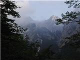
We start at Žagana peč, or half an hour lower at Kamniška Bistrica. Some meters above Žagana peč, where from Kamniška Bistrica the blazes towards the saddle Kokrsko sedlo lead us, on the left side of the road from the parking space a well-beaten hunting footpath branches off. It rises through steep forest and crosses some gullies. We stick to the left direction and in a good hour we come to a small saddle, where there stands a hunting cottage with a bench (nv 1330 m). The path turns right above the cottage along the left slope of the hill and then along a natural gully. The footpath is all the time quite steep and pleasantly soft. At the end of the gully a beaten path branches off to the right to Zob and further to Kalška gora and not to Čmaževski turn, which is lower. We follow the path straight ahead, which starts to get lost in the dwarf pines and becomes flatter. The path almost completely avoids the dwarf pines and completely gets lost on the high mountain meadows of Kalce. If we follow the bottom of the indistinct valley (cairns help us), we come to the scree and across it to the marked path, which we follow to the right towards Kokrsko sedlo. Across the steep spot a steel cable helps us. In 10 minutes we come to the path junction, where we turn right towards Kalška gora. To the summit we have another good 5 minutes along a panoramic grassy path. Car-hunting cottage 1h10', hunting cottage-marked path 1h50', marked path-summit 15'.
At the descent it is harder to find the footpath if we did not ascend along this path.

Photos:
 1
1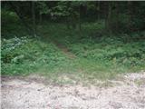 2
2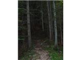 3
3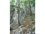 4
4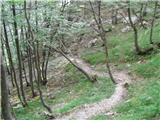 5
5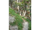 6
6 7
7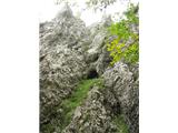 8
8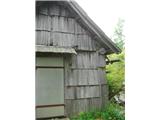 9
9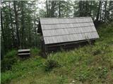 10
10 11
11 12
12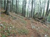 13
13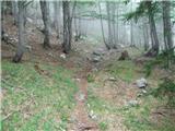 14
14 15
15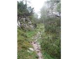 16
16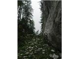 17
17 18
18 19
19 20
20 21
21 22
22 23
23 24
24 25
25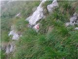 26
26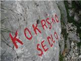 27
27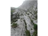 28
28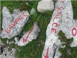 29
29 30
30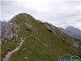 31
31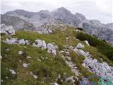 32
32
Discussion about the trip Žagana peč - Kalška gora (Hunting trail)
|
| jprim10. 09. 2008 |
Wonderful tour, close encounter with chamois, blueberries along the path (in August), return via Kokrsko sedlo, which is of course more demanding.
When I did this tour, there was no description yet, but with the help of the Kamniško-Savinjske Alpe guide, there were no problems.
Best regards.
|
|
|
|
| fpetel115. 09. 2008 |
At the end of the gully, a secured path branches off to the right to Zob and onwards to Kalška gora and not to Čmavski turn, which is lower
|
|
|
|
| sebanakis15. 09. 2008 |
bravo franc! congratulations on the tour. See you somewhere. Sebastjan
|
|
|
|
| grega_p17. 10. 2009 |
In the upper section (the bottom of the indistinct valley is called Ovcarija) there are red marking lines drawn everywhere, which nicely lead to the marked path. Otherwise a really nice remote route, especially in this time of autumn colours.
Be careful in the upper section though - where it's lightly snowed, it's already a bit icy.
Cheers :-)
|
|
|
|
| jprim18. 10. 2009 |
Well, perhaps you noticed that up to the hunting hut those marking lines have been removed, someone painted something, the hunters erased it, at least up to the hut. Actually it's not a hiking trail, so there shouldn't be any markings on this path.
Best!
|
|
|
|
| felix12. 07. 2010 |
On Saturday 10.7. we went on this path, really wonderful path, easy to follow. From Kalška gora we went to Kalški greben, then towards Vrh Korena and along the lower path under Kalški greben back to the hunting path, by which we ascended.
best regards
|
|
|
|
| pohodnik3824. 06. 2012 |
Since no one has written here for a long time... I hiked the path last week and can only praise it: great path and unforgettable especially that view of the central peaks of KSA... the path really disappears a bit at times but can be followed, only in fog especially on Kalci it can be a problem. Otherwise no peculiarities, no trace of snow, it was winter at all....
And one more thing PICTURES HERE
Safe steps to all in the mountains.
|
|
|
|
| love mount30. 12. 2012 |
it was wonderful some difficulties on miliščua ok. from kalška kora to kokrško sedlo fog and risk of slipping   
|
|
|
|
| garmont18. 11. 2014 |
The described path is somewhat exposed in the lower part, crosses some exposed gullies, in the upper marked part there are also steel cables to help. I think the path is more difficult than described (easy unmarked trail). In wet conditions even more so....
|
|
|
|
| Tadej18. 11. 2014 |
Thanks for the info. I have corrected the difficulty rating of the path.
|
|
|
|
| fpetel12. 10. 2016 |
It says: partially difficult unmarked path, difficult marked path
In the lower part there are no fixed protections and in dry conditions they are not needed, on the marked part there are some protections. Over Zob to the summit unmarked path. A while ago there were red lines everywhere that safely avoided the scree.
|
|
|
|
| jprim6. 10. 2016 |
Well, two years after the last post, tips for the ascent????

|
|
|
|
| redbull6. 10. 2016 |
great path, but not recommended in fog if the path is not known exactly
|
|
|
|
| ljubitelj gora1. 09. 2020 |
Walked today 1.9, well traceable path. On the scree there are cairns, then you reach the marked path like that.
|
|
|
|
| AndrejS14. 06. 2021 13:45:26 |
Trail is easily followable. Still in the forest there's one wrong descent trodden by hikers who missed the path a bit (right after the log with sawn-out steps). Already below Ovčarija we step onto snow, the secured ascent along the cable and ridge are snow-free. For the approach to the summit via the marked path from Kokrško sedlo, winter gear is still needed (ice axe, crampons).
|
|
|
|
| ljubitelj gora22. 11. 2021 11:26:26 |
On picture 22 I turned right onto a less visible path (chamois trail perhaps), along the slope with some minor climbing I looked for the easiest passages to the scree.
|
|
|
|
| gams116. 06. 2025 09:17:34 |
currently logging is taking place at or above Žagana peč, so fallen trees make the start of the path quite difficult
|
|
|
To post a comment you must log in:
If you do not yet have a username, you must first
register.