Zadnjica - Triglavska vojašnica Viktorja Emanuela III. (via Plemenice)
Starting point: Zadnjica (642 m)
| Latitude/Longitude: | 46,3824°N 13,7604°E |
| |
Route name: via Plemenice
Walking time: 6 h 20 min
Difficulty: very difficult marked way, easy unmarked way
Elevation gain: 1878 m
Elevation difference along the route: 1885 m
Map: Triglav 1:25.000
Recommended equipment (summer): helmet, self belay set
Recommended equipment (winter): helmet, self belay set, ice axe, crampons
Views: 15.753
 | 3 people like this post |
Access to starting point:
From Kranjska Gora, drive over Vršič Pass towards Bovec or vice versa, but only to the 50th hairpin turn of the Vršič or Russian Road (near the village of Trenta). Here, turn onto the side road, along which after a few hundred meters park at the parking lot by the road.
Route description:
From the paid parking lot in Zadnjica Valley, continue on the marked path, initially along the road towards Pogačnikov dom na Kriških podih, Razor, Stenar, Križ, Bovški Gamsovec, Luknja, Triglav, Koča na Doliču and Kanjavec. The path first leads past a few houses or cottages and after about 15 minutes of walking brings us to a marked junction where there used to be a free parking lot, but parking is now prohibited here.
Continue along the slightly right lower road towards Zasavska koča na Prehodavcih, Koča na Doliču, Luknja and other nearby destinations (left to Pogačnikov dom na Kriških podih and other goals above Kriških podih and the lower station of the cargo cableway to Kriških podih), where the gentle road continues across scenic meadows, higher up through the forest. Just before the end of the forest road at the Planja junction or before the valley head in the area called Utro, a marked path branches right towards Prehodavci.
Continue straight along the road, which soon turns into a hiking path or old military mule track, along which we mostly ascend moderately on increasingly steeper slopes. Still in the forest, a climbing path branches right over Komar, but we continue along the mule track, which ascends in numerous hairpins, and due to the steep slopes above us, parts of the path are exposed to falling rocks.
The fairly scenic path brings us at about 1500 meters above sea level to the next junction, where the path to Koča na Doliču branches right, and we continue straight towards Luknja, Pogačnikov dom na Kriških podih and Triglav via Plemenice.
We continue ascending along the mule track, which leads above Koriti, and we follow the path, which is still partly exposed to falling rocks, to the marked junction at Luknja, where we join the path from the Vrata Valley starting point and from where a nice view opens to the other side.
From Luknja, head right towards Triglav (left to Bovški Gamsovec and Pogačnikov dom, straight down to Aljažev dom in Vrata).
The path becomes very demanding and starts with an almost vertical ascent secured by a chain. After climbing the initial wall, the path levels slightly, but this does not mean the end of difficulties. From here, there are almost no safety features, and occasionally we walk on a trail above a deep abyss. In wet conditions, high risk of slipping! The difficulties gradually ease, and the path turns slightly left, leading us to a ridge from where a view opens to the east. We continue along the scenic ridge, and the path soon becomes somewhat demanding again. With the help of a chain and numerous pegs, we ascend steeply several times, followed by a short steep descent. Here, a view opens to the left towards the famous Sphinx (the steepest Triglav pillar).
The path then becomes less steep and leads through scree terrain. The trail is somewhat less visible here, running left of Glava v Zaplanji and Triglavska vojašnica Viktorja Emanuela III. (formerly incorrectly named Morbegna), which we see ahead. On this section, there may still be some snow patches even in summer, but they are not steep, so an ice axe is usually not needed.
The path then leads to a junction on the Western Triglav Plateau.
Here, continue right (left to Triglav, slightly right to Dolič) along an unmarked path, which after another 10 minutes of walking brings us to vojašnica Viktorja Emanuela III. (sometimes incorrectly named Morbegna).
Starting point - Na placu 0:15, Na placu - Utro 1:00, Utro - branch to Komar 0:15, branch to Komar - Pod Skokom 1:10, Pod Skokom - Luknja 0:45, Luknja - Plemenice 2:00, Plemenice - Zaplanja junction 0:45, Zaplanja junction - vojašnica Viktorja Emanuela III. 0:10.

Along the route: Na placu (714m), Utro (984m), Odcep za Komar (1058m), Pod Skokom (1494m),
Luknja (1766m), Plemenice (2372m), Zaplanja (2428m)
Photos:
 1
1 2
2 3
3 4
4 5
5 6
6 7
7 8
8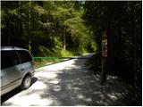 9
9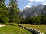 10
10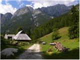 11
11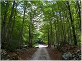 12
12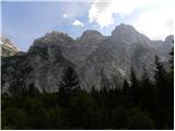 13
13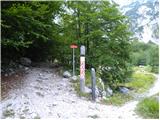 14
14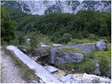 15
15 16
16 17
17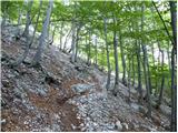 18
18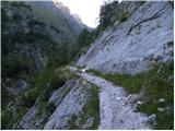 19
19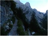 20
20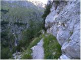 21
21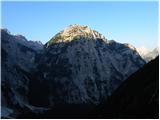 22
22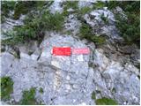 23
23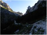 24
24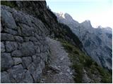 25
25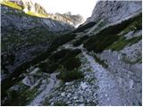 26
26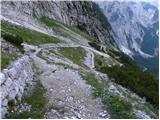 27
27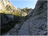 28
28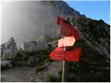 29
29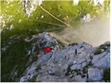 30
30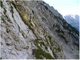 31
31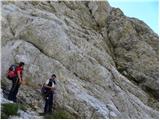 32
32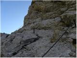 33
33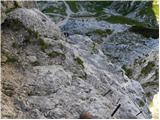 34
34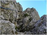 35
35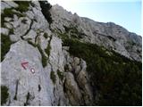 36
36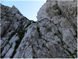 37
37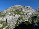 38
38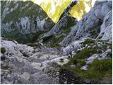 39
39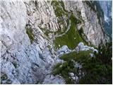 40
40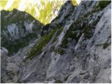 41
41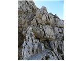 42
42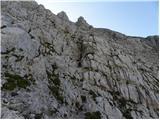 43
43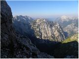 44
44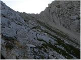 45
45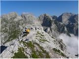 46
46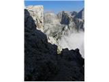 47
47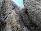 48
48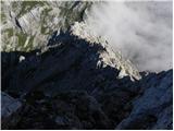 49
49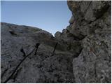 50
50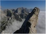 51
51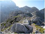 52
52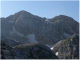 53
53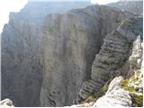 54
54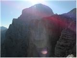 55
55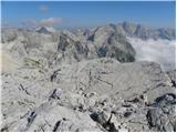 56
56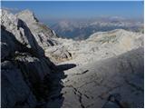 57
57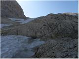 58
58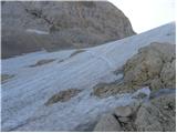 59
59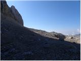 60
60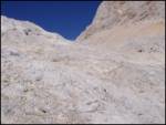 61
61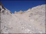 62
62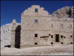 63
63
Discussion about the trip Zadnjica - Triglavska vojašnica Viktorja Emanuela III. (via Plemenice)
|
| Pobesneli delfin19. 03. 2008 |
I think the fully correct name is 'Morbegno', not Morbegna. Anyway, it is named after a place in southern Italy.
|
|
|
|
| triglavski21. 03. 2008 |
The above description is mildly put poor, full of errors and thus useless. Mulatjere are of course not from the time of WWI, since there was no front line there, but from the interwar period during Italian occupation of Primorska, the timelines are odd, unrealistic, overly stretched. The path description itself is deficient and very generalized, not representing the real difficulty of the mentioned secured path, even misleading. No one will see the Sfinge unless they know where to look over the edge.
Pobeseneli delfin is right only about the name, the place's name is indeed "Morbegno" (we address it as Morbegna - Morbegna barracks, in feminine), but of course this place is not in southern Italy, but northwest in the Lombardy region, Sondrio province in the Bormio valley by the Adda river. Beautiful places, though it's been many years since I was around there.
|
|
|
|
| McNena16. 02. 2012 |
I was in this area in summer 2011, but if I may say, this building is demolished.  Of course, if I saw the real one, it was almost on the path from Triglav via Škrbina towards Dolič. Of course, if I saw the real one, it was almost on the path from Triglav via Škrbina towards Dolič.
Please, can someone confirm my observations, as I feel I might have missed it, since on the pictures it's such a mighty structure.
Thanks for the reply.
Best regards
|
|
|
|
| slainter16. 02. 2012 |
I was on the path via Plamenice to Triglav end of September and by the way also at Morbegni. Attaching pictures, that's how it looked, all demolished. best regards
|
|
|
|
| IgorZlodej17. 02. 2012 |
here pictures cannot be uploaded
|
|
|
|
| lingo17. 02. 2012 |
The current condition is even much worse and no longer gives the impression of a large building. The caption under the upper picture is also wrong, because in 1918 the Italians did not even have Morbegne on paper, this was not an object from the time of the First World War
|
|
|
To post a comment you must log in:
If you do not yet have a username, you must first
register.