Starting point: Zadnjica (642 m)
| Latitude/Longitude: | 46,3824°N 13,7604°E |
| |
Walking time: 6 h
Difficulty: very difficult marked way
Via ferrata: C
Elevation gain: 1959 m
Elevation difference along the route: 1990 m
Map: Triglav 1.25.000
Recommended equipment (summer): helmet, self belay set
Recommended equipment (winter): helmet, self belay set, ice axe, crampons
Views: 120.809
 | 9 people like this post |
Access to starting point:
From Kranjska Gora we drive over the Vršič pass towards Bovec or vice versa, but only up to the 50th hairpin bend of the Vršič or Russian road (near the village of Trenta). Here we turn onto the side road, along which we then park after a few hundred meters at the parking lot by the road.
Route description:
From the parking lot we continue along the road, which takes us past a few houses, mainly weekend homes, in about 15 minutes to the place where the road splits into two parts (at the junction there was once a parking lot, today parking is prohibited).
From the old parking lot we head onto the left road in the direction of Pogačnikov dom na Kriških podih (the right road leads towards Prehodavcem and Doliču). After 15 minutes of further walking the road brings us to the lower station of the cargo cable car, where it ends.
We continue the ascent along the marked footpath, the mule track, which ascends moderately through the forest. The path that ascends above the valley of Belega potoka quickly brings us to very steep slopes (danger of falling rocks), across which a wide path leads. The path ahead crosses the gorge Veliki Presek, after which we come to a short exposed ledge, across which we pass with the help of a steel cable. Further the path returns to the forest, where it ascends moderately in numerous switchbacks. A little further the path brings us under a smaller overhang, where we can observe numerous sticks that hikers place so that the rock does not roll into the valley (the sticks are placed more for fun than seriously). The path ahead crosses a few smaller gullies, then past a small chapel brings us to a larger gully. With some caution (easy) we cross the mentioned gully, after which in a few minutes of further walking we ascend to a pleasant resting place (two benches by the path). Next we cross another larger gully (possibility of snowfield in early summer), then the path returns to the forest. Higher up the forest becomes sparser, the path somewhat steeper and increasingly scenic.
The path, which continues ascending along the old mule track, then takes us past two more benches into the dwarf pine belt, after which we enter a rockier world. Further we ascend across smaller screes, along an increasingly scenic path, which higher up brings us to a pleasant little spring (source).
Just a few dozen steps above the mentioned spring, we come to an unmarked junction, where an unmarked path branches off to the right towards Spodnjemu Kriškemu jezeru to which it is two minutes' walk, we continue slightly left along the still wide mountain path. The path ahead leads us past smaller ruins, we follow it all the way to the marked junction, where the path from the valley of Vrata joins us from the right. We continue left and after two minutes of further walking we arrive at Pogačnikov dom na Kriških podih.
Just a few dozen steps above the mentioned spring, we come to an unmarked junction, where an unmarked path branches off to the right towards Spodnjemu Kriškemu jezeru, to which it is two minutes' walk, we continue slightly left along the still wide mountain path. The path ahead leads us past smaller ruins, we follow it all the way to the marked junction, where the path from the valley of Vrata joins us from the right. We continue left and after two minutes of further walking we arrive at Pogačnikov dom na Kriških podih.
From Pogačnikov dom we continue in the direction of Razor and Križ along the path that slightly descends and in a few steps brings us to the next junction, where we go left (right Križ, Škrlatica and Krnica).
The path ahead leads us left transversely across the scree, where we also descend a little, then the path is stopped by a rock step. We climb it with the help of fixed protections and at the top of the step we continue left along the exposed rock slab. On the other side of the slab we find ourselves again on the scree and continue along it further towards the sedlo Planja, where the path from Vršiča also joins us.
From the sedlo Planja we continue sharply right (left Planja, straight Vršič) along the path that initially ascends through natural passages, where the path is occasionally only slightly exposed. A little further the path leads us past a cave in which ice and snow usually persist almost all year round. From the cave onwards we ascend towards the notch, where we must be careful not to trigger rocks. A little further we arrive at the place where the new path separates from the old one. The old path is permanently closed due to the rockfall in the year 2013, so we head right onto the nicely marked new path, along which we quickly arrive at a short but very demanding ascent, where according to the recommendations of the PZS the use of a self-belay set is mandatory. With the help of a steel cable and rungs we ascend the vertical or on a short section even overhanging chimney, which is also quite exposed to falling rocks due to rocks above the chimney. When the secured section ends, only the ascent along the scenic ridge to the summit of Razor remains.
Starting point - Na placu 0:15, Na placu - lower station of the cargo cable car 0:15, lower station of the cargo cable car - Na Utrci 2.00, Na Utrci spring below Kriškimi podi 1:05, spring below Kriškimi podi - Spodnje Kriško jezero 0:05, Spodnje Kriško jezero - Pogačnikov dom 0:20, Pogačnikov dom - sedlo Planja 1:05, sedlo Planja - Razor 0:55.

The trip can be extended to the following destinations: Križ
Photos:
 1
1 2
2 3
3 4
4 5
5 6
6 7
7 8
8 9
9 10
10 11
11 12
12 13
13 14
14 15
15 16
16 17
17 18
18 19
19 20
20 21
21 22
22 23
23 24
24 25
25 26
26 27
27 28
28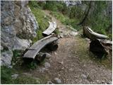 29
29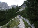 30
30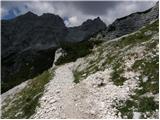 31
31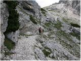 32
32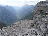 33
33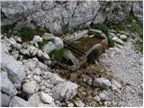 34
34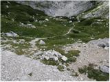 35
35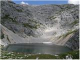 36
36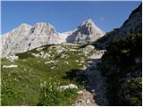 37
37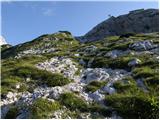 38
38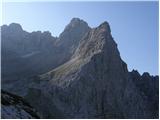 39
39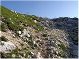 40
40 41
41 42
42 43
43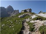 44
44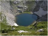 45
45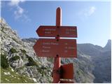 46
46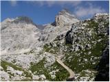 47
47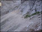 48
48 49
49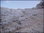 50
50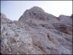 51
51 52
52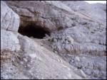 53
53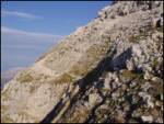 54
54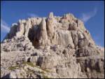 55
55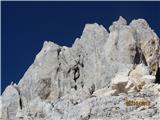 56
56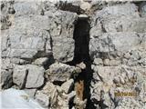 57
57 58
58 59
59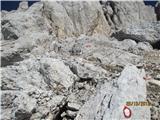 60
60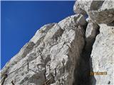 61
61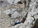 62
62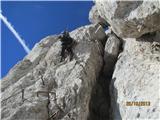 63
63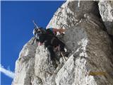 64
64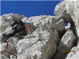 65
65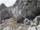 66
66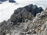 67
67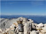 68
68 69
69
Discussion about the trip Zadnjica - Razor
Show older messages
|
| Gost20. 08. 2007 |
Last week I ascended from Zadnjica via Kriški podi to Razor. The path to Kriški podi is like a fairy tale, easy and very pleasant to walk. The path to Planja saddle drags a bit, which takes quite some strength, as most of it is over scree. The path to Razor itself is now cairn-marked, meaning they will obviously equip it, making it accessible to broader masses of hikers. For me, the view of the north face, Sphinx and its face, and Triglav is truly the most beautiful right from Razor. On return to the saddle, I recommend ascending to Planja 2453 m. A bit of scrambling at the start, then easy ascent to the top. It takes about 10-15 minutes. Best, Andrej.
|
|
|
|
| Gost26. 08. 2007 |
Yesterday my colleague and I were on Razor. Due to newly formed rock slides right below the summit where part of the path is buried, access to the top due to falling rocks is very dangerous, so I recommend approaching right under the wall about 20 meters above the trail. From the top the view is really nice. Lp Darko
|
|
|
|
| Gost28. 08. 2007 |
Quote: http://www.pzs.si/novice/novica.php?id=3042
27.08.2007 - URGENT WARNING
The Commission for Mountain Trails at the Alpine Association of Slovenia and the Alpine Association Radovljica warn!
On Saturday, 25 August 2007 at 18:00, a large rockfall occurred in the summit part of Razor. The mountain trail leading to Razor from Planja saddle towards the summit of Razor is partially buried with rocks in several places. Some cables and pegs are also damaged. Due to damaged protections and loosened rock that occasionally still moves spontaneously, the trail to the summit of Razor is TEMPORARILY CLOSED.
We therefore warn all hikers not to use it. The trail closure is in effect until further notice.
We again warn all visitors to secured high mountain trails that walking on them without a helmet and via ferrata kit can be deadly dangerous.
Alpine Association of Slovenia
Trail Commission of the PZS Executive Board
|
|
|
|
| dsusnik30. 07. 2009 |
Hello!
It's already two years since that warning! In the coming days my wife and I plan to head to Razor. Can someone please tell me what the current condition is?
Many thanks!
|
|
|
|
| dsusnik31. 07. 2009 |
 Thanks a lot for the reply! Thanks a lot for the reply!
|
|
|
|
| bobi4. 08. 2009 |
WITH A FRIEND WE SET OFF ON 1.08.2009 FROM ZADNJICA TO RAZOR. THE PATH IS VERY BEAUTIFUL, SO I RECOMMEND THE ASCENT TO RAZOR TO EVERYONE. ON RAZOR THERE IS A VERY NICE VIEW OF THE OTHER MOUNTAINS IN THE JULIAN ALPS.
|
|
|
|
| pipe5. 09. 2009 |
HELLO
I'm interested in the upper part of the path regarding friability.
Is the path secured in any way?
|
|
|
|
| naty 15. 09. 2009 |
No, the path is not secured at all, but it is really highly recommended to wear a helmet, especially dangerous if someone is walking above you, especially from the saddle upwards, because the mountain is not made of compact solid rock but as if someone had thrown a pile of stones there, but the path is not technically demanding either.
|
|
|
|
| NEIC0087. 07. 2010 |
Hello!
Has anyone been up there this year (June-July)? Is there any snow? etc.?
Thanks!
|
|
|
|
| NEIC00810. 07. 2010 |
Today I puffed up to Razor. The path seems fairly dangerous to me due to slip hazard and falling rocks triggered even by chamois.Too few or no protections?? The summit won't last long, as you can even move the rock where the stamp is attached. In short, everything moves, space on top for two sturdier hikers and that's it.
|
|
|
|
| to326. 06. 2011 |
I'm curious about the conditions on the path Kriški podi - Razor? Thanks in advance for all information!
|
|
|
|
| dsusnik8. 07. 2011 |
I'm also interested how it is now up on Razor - is it really so critical as NECIO08 writes? 
|
|
|
|
| Lisa12. 07. 2011 |
to3: Check the path from Aljažev dom, maybe there you have more info on the conditions you're asking about.
Best, S.
|
|
|
|
| matic412. 07. 2011 |
The path is indeed quite slippery and gravelly. The rocks are still holding together pretty well. There's still room on the summit for at least 10 people. Stones are mainly dislodged by hikers, so a helmet is highly recommended. It's certainly not an easy path. There's still room on the summit for at least 10 people. Stones are mainly dislodged by hikers, so a helmet is highly recommended. It's certainly not an easy path.
|
|
|
|
| britof5. 08. 2012 |
02.08.2012, I set off from Zadnjica to Razor in 5 hours. Towards the summit the path is quite strenuous, especially dangerous due to falling rocks, it's only a question of time when a large rock mass, which is possibly undermined, will roll into the valley. Great caution and helmet mandatory.
Otherwise one of the best views in the Julians.
L.P.
|
|
|
|
| ibro19. 08. 2012 |
Planning a trip to Razor, up from Zadnjica, then back to Pogačnikov dom, next day to Vršič, because I don't want to return the same way. I think at Vršič I would already find someone to drive me down (50 hairpins), but how is it further to the parking lot - starting point?
|
|
|
|
| ZOJA20. 08. 2012 |
Ibro, you only need a couple of minutes to the parking lot. My husband and I did the tour on Friday and returned to Zadnjica, it was hot like in a kettle.... the road to the barrier is supposedly prohibited, but most drive up anyway. So leave the car near the Zadnjica exit, it extends the path by only 15 minutes. Razor towards the top is very poorly marked, so caution is not superfluous....lp
|
|
|
|
| ibro20. 08. 2012 |
Zoja, thanks for the reply. Did you do Razor in one day? I believe it was hot as hell in the afternoon!
LP
I
|
|
|
|
| ZOJA21. 08. 2012 |
From Zadnjica we set off already on Thursday morning, approximately at half past ten. Thunderstorms were forecast, so we hurried and arrived at Pogačnikov dom just before the rain i.e. at half past one. It rained until evening, there were many hikers in the hut who also intended to sleep over, so we weren't bored. The next day before six to Razor and back to Zadnjica, the path (mula tera) dragged on for us a lot.....
|
|
|
|
| Jure8713. 09. 2012 |
Razor looks as if it was once the most mighty mountain far and wide, but over the millennia the tooth of time has found it well, as the summit ridge is noticeably weathered. The approach is quite physically demanding, as the steep scree thoroughly exhausts you. I recommend visitors to also climb the nearby Planja, from which there is a beautiful view of the Razor summit and the Kriške pode.
|
|
|
|
| bostjanp13. 09. 2012 |
Razor is still a mighty mountain and the summit is deserved by anyone who climbs it. For me, Razor is a unique mountain among ours. It has its own charm that no other mountain has.
|
|
|
|
| gfekonja8. 07. 2013 |
Hello!
Does anyone perhaps have any information on the conditions at Razor (access, markings).
I plan to visit it soon, so I would greatly appreciate fresh info.
Best regards
|
|
|
|
| U&Q8. 07. 2013 |
The path to Razor is CLOSED from 3.7.2013!!! The notice is also at the top of the news on the front page of this portal.
|
|
|
|
| gfekonja8. 07. 2013 |
Yes, I overlooked the notice on the first page because Google led me to this link.
But anyway, thank you very much for the quick response.
Now I'm very disappointed, because I've been thinking about Razor for a long time
|
|
|
|
| CarpeDiem2478. 07. 2013 |
Razor won't run away anywhere, it's definitely worth waiting, as this looks very dangerous.
|
|
|
|
| jedriličar13. 11. 2013 |
Regarding the newly laid path to Razor, it would be good if the images from Planja saddle onwards are changed in all path descriptions to Razor, and also the textual path description, so that the existing description does not mislead those who don't know the change in the next season....
|
|
|
|
| CarpeDiem24713. 11. 2013 |
I agree, this way a possible accident on Razor can also be prevented.
|
|
|
|
| andrejp13. 11. 2013 |
actually only the last 2 pictures and the last 2 sentences of the description
|
|
|
|
| mukica13. 11. 2013 |
I have pictures from the new section....
|
|
|
|
| jedriličar14. 11. 2013 |
Just make a description and add a few pics, and send it to the admin ....
|
|
|
|
| Tadej14. 11. 2013 |
The description has been corrected, and new pictures have been added. Pictures and descriptions will soon be changed also for other routes to Razor.
Thanks again to Mukica for the pictures.
Best regards, Tadej
|
|
|
|
| CarpeDiem24714. 11. 2013 |
Bravo, this can really be called quick and effective
|
|
|
|
| dare2915. 11. 2013 |
Another thought of mine on this occasion.
I have often missed the entry date of the trip in the trip descriptions, precisely because of the "actuality" of the description.
If comments follow the description, you at least have an approximate date, otherwise you're without.
nice day, Dare
|
|
|
|
| darinka46. 05. 2015 |
I'm interested if anyone went last summer from Križki podi to Razor on the new marked path, and what it's like? Regards
|
|
|
|
| ajax6. 05. 2015 |
SOMEONE WENT, I'LL GO THIS YEAR.
|
|
|
|
| Matej_K.7. 05. 2015 |
It's beautiful The last couple of minutes below the summit is a short slightly overhanging vertical, otherwise nothing special.
|
|
|
|
| darinka47. 05. 2015 |
Thanks for the info, I went on the old marked path many years ago, so I'll go on this one this year.
|
|
|
|
| deusomega16. 05. 2015 |
I'm just wondering what the current conditions are for Razor. Is it still under snow? Is an ice axe needed? I'll take colleagues to Kriški podi from Zadnjica, but I want to go to the top of Razor myself. Thanks for the information. Regards
|
|
|
|
| pikica116. 05. 2015 |
Too bad, because for current conditions you're asking the wrong person. I can't attach the picture I have. Check under current conditions under the Razor topic, I'll put it there.
|
|
|
|
| Tomy66993. 11. 2016 |
Wow - great view of Triglav from below Križ, which is near Razor - it was phenomenal: View of Triglav
|
|
|
|
| J.P.15. 09. 2019 |
14.9 - Zadnjica-Razor-Planja-Zadnjica. Helmet obligatory on the path to the summit. Also caution due to slip risk. The trail is exceptionally beautiful even though it drags a bit from Zadnjica. I recommend visiting Planja on the way from Razor especially to those who like to avoid crowds at the summit. Best
|
|
|
|
| glorija1. 09. 2020 |
On 26.9.2020 the path took me from Zadnjica to Razor.. the path is very nice through the forest with soft ground, which is a real balm for the feet on the return.. it gradually turns into a mule track to the hut at Kriški podi where the young guys and girls in the hut are very friendly, they serve very good food and take care of good mood.. everything flowed so calmly among them, spontaneously and I can hardly wait to see them again as there are quite a few interesting unconquered peaks that don't give me peace.. the path to Razor requires endurance time to the top, but it's not as exposed as I heard before, definitely it's better to do a similar tour beforehand so that the pleasures are even greater.. the descent from the overhanging chimney also requires a lot of caution ... but in both directions stones were falling luckily a little off the path despite the small number of visitors and there really was no crowd here as I hear elsewhere... safe steps to all and greetings, good luck
|
|
|
|
| turbo1. 09. 2020 |
gloria,
next time also refreshment in the pool under Pinja waterfall (Belopotoški slap). At the lower station of the cargo cableway step onto the road and there, where the road turns right downwards, turn left onto a less visible path (sometimes cairns). After a few steps you already see the waterfall and below it a quite deep pool (pothole). Cold, sometimes very cold water, but after the tour it feels great
|
|
|
|
| glorija11. 09. 2020 |
Turbo big thanks..due to a misunderstanding I even took my swimsuit to Razor , of course I didn't use it anywhere hehehe....Thanks for the idea as I plan to spend a few days in Bovec to use the vouchers and this info will come in very handy...may your steps be safe and light wherever you are and will be , of course I didn't use it anywhere hehehe....Thanks for the idea as I plan to spend a few days in Bovec to use the vouchers and this info will come in very handy...may your steps be safe and light wherever you are and will be
|
|
|
|
| Kinki6. 07. 2023 12:30:40 |
Hello. I'm interested in conditions on the path Zadnjica-Kriški podi-Razor. If there's still snow or winter gear needed. Thanks for answers.
|
|
|
|
| mirank6. 07. 2023 13:45:03 |
Up to K podi it's all dry of course, further on call the hut
|
|
|
|
| Mark020. 08. 2023 18:54:40 |
The trail from Zadnjica to Kriški podi seems to me the most beautiful mountain trail we have. It's not steep, very interesting with views, footholds wedged under rocks, water sources, and even the lower Kriško lake. Really beautiful trail. Only regret is that I didn't stretch to the waterfall at the lower station of the cargo cableway. Next time.
TNP rangers come for checks early in the morning and sniff around windshields, on return I saw quite a few "ranger notice" stickers, so make sure the car is in the marked parking spot and the parking ticket hasn't expired.
Pegs on the last vertical section below the summit are now more densely placed so climbing the ladder is no problem. Still careful, on the overhanging parts and at the end you need to hold on well.
Really wonderful trail, so I saved Planja for another time
|
|
|
|
| Tajka6717. 09. 2023 12:46:04 |
Yesterday ascent to Razor via this route. Only when you first see the PD the sun shines on it, which is nice. From the hut to the saddle tons of scree, from the saddle to the top fog accompanied us. After the lojtra which is a bit overhanging I had SVK, safety first. Very nice tour.
|
|
|
|
| oven7. 07. 2024 19:49:34 |
Hello. I'm interested in the conditions on the path Zadnjica-Kriški podi-Razor. Is there still any snow? Thanks!
|
|
|
|
| PlaninecM17. 10. 2024 20:51:54 |
Hello. I'm interested if there's any snow on the path to Razor or if the path is accessible? Thank you.
|
|
|
|
| Vrhovka13. 08. 2025 21:10:54 |
Path hiked today. To the kriskih podov at moderate pace it took me just under 3h today, then another 2h to Razorja. The path from the hut to the top of Razorja requires real focus and caution, as stones slide a lot, and the terrain is quite tricky for descent. Slowly and carefully it goes.
Parking is paid 10eur/day via easypark
|
|
|
To post a comment you must log in:
If you do not yet have a username, you must first
register.