Zadnjica - Belopotoški waterfall
Starting point: Zadnjica (642 m)
| Latitude/Longitude: | 46,3824°N 13,7604°E |
| |
Walking time: 35 min
Difficulty: easy unmarked way
Elevation gain: 78 m
Elevation difference along the route: 85 m
Map: TNP 1:25.000
Recommended equipment (summer):
Recommended equipment (winter):
Views: 15.144
 | 3 people like this post |
Access to starting point:
From Kranjska Gora, drive over Vršič Pass towards Bovec or vice versa, but only to the 50th hairpin turn of the Vršič or Russian Road (near the village of Trenta). Here, turn onto the side road, along which after a few hundred meters we park at the parking lot by the road.
Route description:
From the parking lot, continue along the road, which takes us past a few houses, mostly weekend cottages, in about 15 minutes to the point where the road splits into two parts (there used to be a parking lot at the intersection, but parking is now prohibited).
From the old parking lot, head onto the left road towards Pogačnikov dom na Kriških podih (the right road leads towards Prehodavci and Dolič). After another 15 minutes of walking, the road brings us to the lower station of the cargo cableway, where it ends.
Just a few meters before the cargo cableway, an unmarked path branches off to the right, slightly downhill, which after a few steps brings us down to the bed of the Beli potok stream. Continue the ascent along a poorer path that leads us up along the stream bed. After a few minutes of walking, the path brings us to the Beli potok waterfall.
Along the route: Na placu (714m), Spodnja postaja tovorne žičnice (797m)
Photos:
 1
1 2
2 3
3 4
4 5
5 6
6 7
7 8
8 9
9 10
10 11
11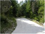 12
12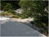 13
13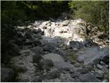 14
14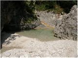 15
15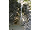 16
16
Discussion about the trip Zadnjica - Belopotoški waterfall
To post a comment you must log in:
If you do not yet have a username, you must first
register.