Za Loncem - Kocbekov dom na Korošici
Starting point: Za Loncem (980 m)
| Latitude/Longitude: | 46,3262°N 14,6543°E |
| |
Walking time: 3 h 30 min
Difficulty: easy marked way
Elevation gain: 828 m
Elevation difference along the route: 1000 m
Map: Kamniške in Savinjske Alpe 1:50.000
Recommended equipment (summer):
Recommended equipment (winter): ice axe, crampons
Views: 25.823
 | 2 people like this post |
Access to starting point:
Access from Luče: In Luče, we head onto the road in the direction of Kamnik and follow the road ahead past the inn Gams and further over the bridge of the stream Lučka Bela. Only a few dozen meters after the bridge, the road into the Lučka Bela valley branches off to the right. We turn onto this road and follow it to the parking lot at the signs Korošica 3:30.
Access from Kamnik: From Kamnik, we drive to Stahovica and further towards the mountain pass Črnivec. Only a little before the pass, the road towards Kranjski Rak branches off sharply to the left. We turn onto this road, which brings us to the pass at Kranjski Rak. Further, we head in the direction of Luče and continue driving on the descending road. When the road brings us into the valley, we will notice signposts for Korošica on the left side of the road. We turn onto this road and follow it to the parking lot at the signs Korošica 3:30.
Route description:
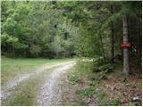
From the parking lot, we head onto the path in the direction of Korošica. Initially a wide and easy path soon brings us to steep slopes, where the path ascends more steeply. The path, which ascends through the forest, a little higher crosses a small clearing, where the steepness eases for a short time. The path then goes back into the forest, where it crosses a torrent and then ascends steeply. A little higher, a beautiful view opens up towards Lučka kopa and Konj. The path ahead slowly transitions into dwarf pines, where it continues to a smaller junction at Vratca. We continue straight in the direction of Korošica, initially slightly downhill (the path to the right crosses exposed slopes below Lastovec). Already after a few steps, the path brings us to the intermittent lake at Stare Stale. Here, next to the lake, we can often notice a group of marmots chasing each other across the grassy slopes. The path ahead starts to ascend moderately again and soon brings us to a stream, which is among the highest in Slovenia. The stream has some smaller waterfalls, which at this elevation stand out particularly. A little higher, the path, which still runs through the dwarf pines, brings us to a junction, where we continue on the left path (right Vodotočnik). The path then ascends a slope that is increasingly less vegetated to Prag (1910m), where a view opens up towards the plain of Korošica. On the left side of the plain, we spot the mountain hut Dom na Korošici, to which we descend and reach it in a few minutes.

Along the route: Šibje (1210m), Vratca (1655m), Stare Stale (1640m), Prag (1910m)
Photos:
 1
1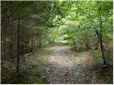 2
2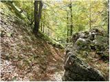 3
3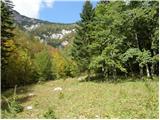 4
4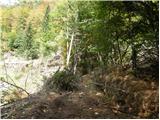 5
5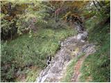 6
6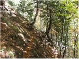 7
7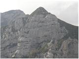 8
8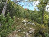 9
9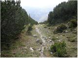 10
10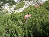 11
11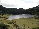 12
12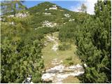 13
13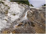 14
14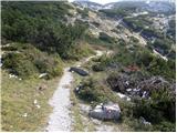 15
15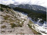 16
16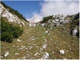 17
17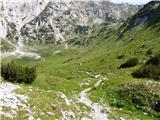 18
18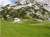 19
19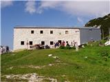 20
20
Discussion about the trip Za Loncem - Kocbekov dom na Korošici
|
| petruša17. 05. 2010 |
On Saturday we'd like to go to Korošica with the family, so I'm wondering if the hut is already open and if there's still any snow left.lp
|
|
|
|
| petruša19. 05. 2010 |
How is it with the snow on the path? lp
|
|
|
|
| zamet19. 05. 2010 |
Today 19.5. I was at Korošica, snow starts at about one third of the path, I went in the afternoon, so it sank a bit. Lp
|
|
|
|
| zamet19. 05. 2010 |
Photos are on "Current conditions"
|
|
|
|
| gorazdjustinek10. 06. 2010 |
hello,
I'm interested if anyone has the contact of the responsible person or info on whether it's possible to rent the hut at the flowing lake or. whether it's possible to overnight there. I can't find contacts anywhere, not even of the gentleman who takes care of the hut on planina Podvežak. Thanks. best regards, Gorazd
|
|
|
|
| irska11. 07. 2011 |
This trail apparently hasn't been used by anyone for a long time  ... Even the forest road is more suitable for off-roaders than "ordinary" cars. This Saturday my friend and I headed to Lučkega Dedca from this starting point and parked where the sign says "Lonec 5 min", which meant 25 minutes of walking. But the marked 3h30min from the signpost onwards is very leisurely ... we two were at the junction for Lučkega Dedca in 2 hours (including 25min walking on the forest road! Also on PZS it says 2h30min to the hut. But it's beautiful!!! And we haven't met so many friendly hikers here at the Savinja end for a long time! ... Even the forest road is more suitable for off-roaders than "ordinary" cars. This Saturday my friend and I headed to Lučkega Dedca from this starting point and parked where the sign says "Lonec 5 min", which meant 25 minutes of walking. But the marked 3h30min from the signpost onwards is very leisurely ... we two were at the junction for Lučkega Dedca in 2 hours (including 25min walking on the forest road! Also on PZS it says 2h30min to the hut. But it's beautiful!!! And we haven't met so many friendly hikers here at the Savinja end for a long time!
|
|
|
|
| danicak11. 08. 2011 |
From the above path description, I'm interested in how exposed the part "cross the exposed slope under Lastovec" is, is the path carved into the rocks there, perhaps safety ropes... I don't have much experience yet, but a lot of desire to visit our beautiful mountains.
Any information will help with my decision. Thanks
|
|
|
|
| ben11. 08. 2011 |
I don't know those crossings under Lastovec, but that part has nothing to do with this path either. It says here that at Vratca you can turn to the slopes under Lastovec, but our path goes straight towards Stare Stale. I walked the above-mentioned path and except for some steeper incline, around pictures 6 and 7, there are no exposed sections. Good luck!!! 
Lp B
|
|
|
|
| danicak12. 08. 2011 |
yes, super, thanks for the explanation, the steepness itself is no problem.
This is the next route to the mountains.
Nice extended weekend,
D.
|
|
|
|
| otiv12. 08. 2011 |
The only issue was the road along Lučka Bela which was rather bad, especially after rains. Otherwise a nice path from the valley to Korošica, without any problems. Once I even saw edelweiss here in the valley and almost couldn't believe my eyes.
Good luck!
|
|
|
|
| garmont12. 08. 2011 |
If you want to cross the scree under Lastovec it's an unmarked but easily followable path. First descend under the wall, which you then cross in a slight ascent. There are no protections on the path, but a nice view of Konj and Rzenik. The exposed sections are about 150 meters. Of course, with fear of heights you have no business here.
Regards
|
|
|
|
| miha8921. 10. 2011 |
Nice greeting, I'm interested how demanding this path is for ascent on snow? Thanks
|
|
|
|
| otiv21. 10. 2011 |
@miha89
I haven't gone in real winter myself, but I've been several times in spring and on the first visit there were quite some orientation problems. If you've been in summer, there won't be problems. Regarding avalanche danger hard to assess, maybe the dangerous part before you reach Stare stale, where the path is steeper. Further on no problems, if you know the direction of the path. Of course in winter you need to start already in the valley at the beginning of the macadam forest road. That's why ski tourers prefer the road to Podvežak and follow it to Planica, up to which the road is also plowed.
Good luck!
|
|
|
|
| miha8922. 10. 2011 |
Thanks, otiv, we tried today but unfortunately it didn't work out. A bit below the drying lake we lost track of the markers and then barely made it through the pines to the lake. Where we then turned back because of time and because it started snowing.
|
|
|
|
| otiv22. 10. 2011 |
I'm sorry it didn't work out for you and as I already wrote it's good to do this trail in summer when it's easier to follow the path. I myself didn't reach Korošica the first time either, but the next time yes.
Otherwise it's a nice trail, a bit less scenic, but still offers the mountaineer what he seeks in the mountains.
|
|
|
|
| Irina23. 10. 2011 |
miha89 22.10.2011
@otiv gave you very good advice. Do the trail first in summer, i.e., when it's dry.
The markers are very faded and almost nonexistent or the signposts are provisionally tied to stakes and on the ground. Under snow you can't see them by chance either. Likewise, the existing markers are mostly "ground-level". In short, unusable. I complained about this already in summer when I went to Korošica via this trail.
It's still easiest to get to the drying lake, further on it's even more annoying, especially if you don't know where the trail goes.
If you really want to hike the trail this winter too, I suggest looking for someone in PD Luče. Surely there are mountaineers there who also visit their nearby peaks in winter and surely know the trail well.
|
|
|
|
| redbull11. 02. 2012 |
please can someone report here if the avalanche danger on this path is high or not, now after 11 February, when a bit more snow has fallen. Now the weather will be better so time for a short trip.
thanks in advance for info
dejan
|
|
|
|
| tisa11. 02. 2012 |
Dejan, I don't know about avalanches, but I think the path is quite long for real winter, unless you don't plan to bivouac at Korošica. You'll have to start the path already at Podvolovjek, because the forest roads probably aren't plowed.
Good luck!
|
|
|
|
| Irina12. 02. 2012 |
redbull 11.2.2012
The path is really long and I think it's not much visited in winter, so you'd be facing walking through deep snow. If you haven't hiked it in summer and don't know it well, I'd advise against it.
Waymarks on this path are a real rarity and even those that exist are tied to wheels on the ground!! There are also very few ground markings, but they don't count in winter anyway. I already complained in summer.
For visiting Korošica-Ojstrica you have another path available, much friendlier and visited even in winter time. From planina Podvežak.
By the way, no GSM signal in some parts of the path.
|
|
|
|
| redbull26. 02. 2012 |
I'm interested in the conditions now, now the road to Lonec is surely passable.
Can you report somehow
regards
|
|
|
|
| tisa26. 02. 2012 |
The road lies in the shade, so there is definitely snow on it, probably not much though.
|
|
|
|
| redbull5. 04. 2012 |
On Saturday I most likely plan to take this trail, I'm interested if anyone has hiked here, is it normally marked or can you get lost-please report as soon as possible
lp
|
|
|
|
| U&Q5. 04. 2012 |
I went on this trail last year. On part of the trail the markings are on the ground (on rocks) and they are not very frequent. I found the way up myself, but downhill I got a bit confused.
|
|
|
|
| redbull5. 04. 2012 |
Do you happen to know where I could inquire about this, what the trail is like. Does anyone know someone local there (starting point before Lonec) thanks lp dejan
|
|
|
|
| U&Q5. 04. 2012 |
I wouldn't know, I hope you get an answer
|
|
|
|
| francimedved5. 04. 2012 |
Just boldly turn at the monument in Podvolovjek into the Lučka Bela Valley, over the wooden bridge straight uphill, not left, through the pasture gate Drive another about 5 km Where after a left bend and steep climb you'll spot on the left a meadow with a sign Korošica, park and continue on the marked trail. When you reach Vratc 1655, you arrive at a larger meadow, cross it on the right side and there you'll spot the markings for Korošica again, Soon you reach a junction where right the path leads to Vodotočnik left to Kocbekov dom.
|
|
|
|
| donat7. 04. 2012 |
Many of us already have GPS devices, so I suggest including the coordinates of the starting point in the trip description.
Often you don't know where to park or where to look for the trail start.
best regards.
|
|
|
|
| Irina9. 04. 2012 |
Bravo! You guys are real pros.
|
|
|
|
| keti127. 07. 2012 |
Has anyone perhaps recently hiked the path from Lučka Bela towards Korošica or even to Lučkega Dedca? I hiked there a few years ago. I'm just wondering if there's anything special, as I've seen info somewhere about fallen trees, etc.
Thanks.
|
|
|
|
| rokštrajhar19. 06. 2017 |
Yesterday I headed to Korošica via this path "za Loncem". But I must tell you, I have never seen such a bad, impassable, partly overgrown path!!! Here it shows that the path markers of PD Celje are not working as needed! I don't know why? Here it shows that the path markers of PD Celje are not working as needed! I don't know why?
|
|
|
|
| sifamora28. 06. 2018 |
Has anyone gone along this path recently? Can you say what condition it's in?
Thanks
|
|
|
|
| Hriboholic21. 04. 2019 |
Today we went on this trail, the path is poorly maintained, markings faded...
In principle, with good attention you can reach the goal without issues... When descending to the lake there was snow. There some improvisation and path finding was needed... similarly a bit above the lake.
But since I checked the route on the map before the trip, there were no major problems. Despite the snow and lack of markings (covered by snow)
it was possible to reach the burned-down hut.
|
|
|
|
| zdejan29. 04. 2022 19:22:09 |
Tried this path today. After 15 minutes lost the path due to fallen trees. Persisted up the gully and off-trail, came out at Vodotočnik. Couldn't continue due to snow above 1800 m, sinking up to waist, no one has trodden the path yet, so turned back. On the way down found the right path. Path in poor condition, covered with leaves and vegetation, markers faded, signpost only once.
|
|
|
To post a comment you must log in:
If you do not yet have a username, you must first
register.