Vršič - Zavetišče pod Špičkom
Starting point: Vršič (1611 m)
| Latitude/Longitude: | 46,4336°N 13,7435°E |
| |
Walking time: 3 h 45 min
Difficulty: partly demanding marked way
Elevation gain: 453 m
Elevation difference along the route: 750 m
Map: TNP 1:50.000, Trenta 1:25.000
Recommended equipment (summer): helmet
Recommended equipment (winter): helmet, ice axe, crampons
Views: 55.777
 | 6 people like this post |
Access to starting point:
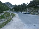
From Kranjska Gora we drive towards Bovec or vice versa, but only as far as the Vršič pass, where we park.
Route description:
From the parking lot at the Vršič pass we head in the direction of Trenta, where we quickly arrive at a small crossroads, where a road closed to public traffic branches off to the left towards the nearby Tičarjev dom and continues to the Poštarski dom, while we go right. Next to the wooden hut where they sell various souvenirs, we notice the beginning of the marked path that leads towards Jalovec and Zavetišče pod Špičkom.
The path takes us after just a few steps to the foot of the scree slope below Mala Mojstrovka, we keep slightly to the left, where the path through a belt of dwarf pines leads us to the foot of the cliffs, along which we descend a little. In the continuation, the path is initially still quite scenic and takes us in a few shorter ascents and descents to a shorter steeper section, where fixed protections help us at two more difficult places, which come in handy when the path is wet or slippery. After the mentioned section, the path gradually begins to descend transversely, and we descend for quite some time, so we get the feeling that the path will lead us into the valley and not into the world around Jalovec. During the traverse, we occasionally get a nice view of the mountains above the Trenta valley, when the path returns to the forest we arrive at a marked junction near the hunting lodge in Rutarska Trenta, which is set a bit off the marked path.
We continue straight in the direction of Zavetišče pod Špičkom (left Zadnja Trenta, right Jalovec) where several more consecutive junctions follow, we follow the marked path in the direction of Zavetišče pod Špičkom. The path ahead first begins to ascend more seriously, we ascend mainly transversely to the left, where when we leave the forest or it thins out we arrive below the cliffs, where we ascend on a stonier path, and along the path the terrain is still quite grassy or overgrown with dwarf pines and shrubs. In the continuation, more and more beautiful views open up, our gaze quickly turns to the interesting spike of Špiček under which Zavetišče pod Špičkom is located, and looking back we have a view of Prisojnik, which is already quite distant, especially if we think that we started the hike in its vicinity. Later, the path turns slightly to the left or towards the southwest and then joins the path from the starting point in Zadnja Trenta.
We continue straight, or slightly to the right and continue to follow the signs for the shelter, the path gradually transitions into the world of pastures. Higher up, from the increasingly scenic path, a path to Jalovec branches off to the right, which bypasses the shelter, while we, along with numerous verses with interesting inscriptions, arrive at Zavetišče pod Špičkom in a few minutes of further walking.
Vršič - Rutarska Trenta 2:15, Rutarska Trenta - junction below Špiček 0:40, junction below Špiček - Zavetišče pod Špičkom 0:50.

Along the route: Rutarska Trenta (1546m), Razpotje pod Špičkom (1769m)
Photos:
 1
1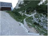 2
2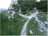 3
3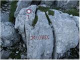 4
4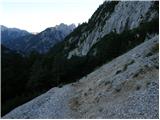 5
5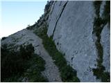 6
6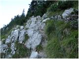 7
7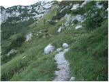 8
8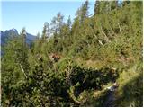 9
9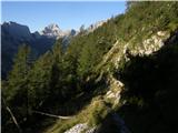 10
10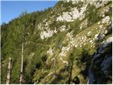 11
11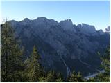 12
12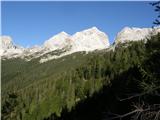 13
13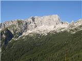 14
14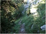 15
15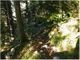 16
16 17
17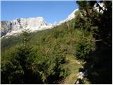 18
18 19
19 20
20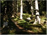 21
21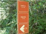 22
22 23
23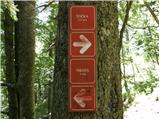 24
24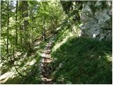 25
25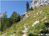 26
26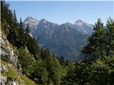 27
27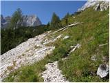 28
28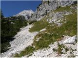 29
29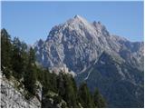 30
30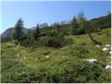 31
31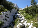 32
32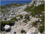 33
33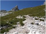 34
34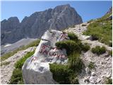 35
35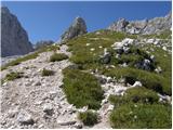 36
36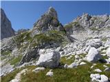 37
37 38
38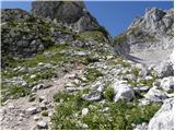 39
39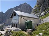 40
40
Discussion about the trip Vršič - Zavetišče pod Špičkom
|
| jaz19. 10. 2010 |
In his 91st year, the legendary caretaker Franc Ciuha - Francelj passed away. His trademarks were the railway cap, flyswatter and old pony bike. He liked to draw a lightning bolt under his signature, which was supposedly related to the fact that lightning once grazed him on the ridge, which I actually never believed. Together we participated in dismantling the old and erecting the new shelter and later for many years when I was the master of the Shelter. Those were also the best times and they will never return. Although my wife and I didn't represent him much, his wife's death in the Košutnikov turn gully deeply affected him. Funeral will be on Thursday in Šentvid pri Ljubljani.
Rest in peace!!! Best regards!
|
|
|
|
| lepenatka20. 10. 2010 |
Yes, Francelj was a legend. I also have good memories of him.
May he rest in peace.
|
|
|
|
| lubnikar20. 10. 2010 |
Yes, Francelj was really a legend. When I arrived at the shelter, he always said "I'm Francelj, here's your tea!" That was instead of a greeting.
|
|
|
|
| lučo20. 10. 2010 |
Legend, may the Slovenian soil be light upon you
|
|
|
|
| Irina22. 10. 2010 |
Francelj!
Thank you for everything! You were the King, both at Kamniško sedlo and later at Špička. I hope you've met your old comrade where you now reign. You know, the one from Tičar, who always wore a black tracksuit. In summer at Vršič, in winter on the ice in Hala Tivoli. Yes, those were the old good times. They won't return, but beautiful memories remain.
me 19.10.2010
Regarding the lightning, you could believe him. He and his colleague went to Planjava and it happened. Francelj always said that God photographed them with a flash. His colleague to the end, him only grazed. And soon after he went from Kamniško to Špička.
|
|
|
|
| ksena22. 10. 2010 |
I also fondly remember Francelj and Božot, the gentleman in the black tracksuit from Poštarski dom at Vršič. And his enigmatic smile, deep gaze... his eyes knew how to say many things without unnecessary words. May both rest in peace.
|
|
|
|
| avrikelj22. 10. 2010 |
Oh, you were awesome, Francelj! We'll remember you, and you watch over us on our paths.
|
|
|
|
| Ajda_Zitnik6. 08. 2012 |
I hiked the trail on Wednesday, 1.8.2012. I would just note that due to the 2 safety features at the start, the trail should not be classified as easy (even on maps, there are dots drawn at those spots indicating difficult or very difficult trail).
The safety features themselves are really undemanding to pass when dry, but I suspect they are dangerous for slipping when wet (that's probably why they were installed).
Otherwise, the trail is nice.
|
|
|
|
| Ajda_Zitnik6. 08. 2012 |
Oh, and one more thing, in both gullies along the trail there is water, but it is stagnant - in my opinion unusable for drinking.
|
|
|
|
| Janiel746. 08. 2012 |
Can someone tell me how long it actually takes from Vršič to that Špička sign 1h 15min? Somehow I'm in doubt where to start for Jalovec. From Flori I took less than an hour to that sign. From Vršič it's probably much longer?? Thanks
|
|
|
|
| Ajda_Zitnik7. 08. 2012 |
I walked from Vršič to Špička in 3.5 hours. To that sign approx. 2 hours and then another approx. 1.5 hours to the hut.
|
|
|
|
| rozinca9. 07. 2013 |
Hello, tomorrow we plan from Vršič to the shelter, then descent to Koča pri izviru Soče. Can someone tell us if there is still any snow on the trail and how long the descent to the Koča pri izviru Soče is expected to take? Thanks 
|
|
|
|
| matejdemsar6. 01. 2018 |
Hello. I was there on 1.11.2017 and didn't find the stamp at the hut. Probably it's inside when it's open. Does anyone know if they have a stamp at Vršič during the season? Thanks.
|
|
|
|
| bo_zl10. 01. 2018 |
During the season the stamp is at the shelter. And there's no need to be at Vršič at that time. But you should visit this shelter anyway - it's quite nice, non-commercialized and more.
|
|
|
|
| AnteP15. 08. 2019 |
Does this spring in picture 19 have water now?
|
|
|
|
| jaz15. 08. 2019 |
It drips a little, drop by drop. Regards!
|
|
|
To post a comment you must log in:
If you do not yet have a username, you must first
register.