Vršič - Velika Mojstrovka (vzhodni vrh) (southern way)
Starting point: Vršič (1611 m)
| Latitude/Longitude: | 46,4336°N 13,7435°E |
| |
Route name: southern way
Walking time: 2 h 30 min
Difficulty: difficult unmarked way
Elevation gain: 755 m
Elevation difference along the route: 800 m
Map: TNP 1:50.000
Recommended equipment (summer): helmet
Recommended equipment (winter): helmet, ice axe, crampons
Views: 76.231
 | 5 people like this post |
Access to starting point:
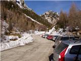
From Kranjska Gora we drive towards Bovec or vice versa, but only as far as the Vršič pass, where we park.
Route description:
From the parking lot at the Vršič pass we head onto the initially poorly marked path that leads to Mala Mojstrovka and Slemenova špica. After a short ascent the path brings us to a larger rock on which we notice the inscription Mojstrovka to the left. We continue in the direction of Mojstrovka (to the right Mojstrovka via Hanzova pot and Slemenova špica) along the path that ascends transversely through a sparse larch forest. After approximately half an hour of ascent the path brings us to an extensive scree slope below Mojstrovka. We cross the mentioned scree slope on the upper side, after which the path leads us into a crumbly gully. This is followed by a steep and slip-hazardous ascent over scree, which we cover in approximately 15 minutes. At the top of the gully the steepness eases and the "sunny" coastal side opens up before us. Here the path turns right and after just a few steps begins to ascend steeply (danger of slipping in snow and ice!). At the top of this ascent we step onto a nice viewpoint, from which a beautiful view opens down towards Vršič. The path ahead moves slightly to the left from the ridge and then crosses two smaller gullies.
A little further on we leave the marked path that leads to Mala Mojstrovka and head left, slightly downhill into the small valley between Mala and Velika Mojstrovka. From the small valley between both Mojstrovkas we continue somewhat to the left (it is also possible along the valley, but higher up the passage is somewhat more difficult), where through the rocky slope a nice passage towards the ridge opens up to us. When we step onto the ridge we go right and quickly ascend to the eastern peak of Velika Mojstrovka.
In winter the entire path is exposed to snow avalanches.
Vršič - Vratca pod Mojstrovko 1:00, Vratca pod Mojstrovko - Velika Mojstrovka 1:30.

Along the route: Za Šitom (1760m), Pod Vratci (1895m), Vratca pod Mojstrovko (1941m), Odcep v Veliko dnino (2033m)
Photos:
 1
1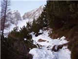 2
2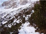 3
3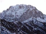 4
4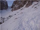 5
5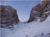 6
6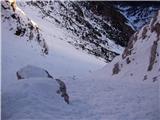 7
7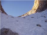 8
8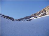 9
9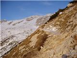 10
10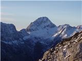 11
11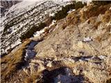 12
12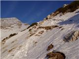 13
13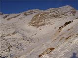 14
14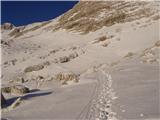 15
15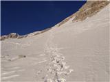 16
16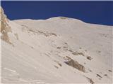 17
17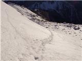 18
18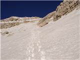 19
19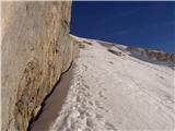 20
20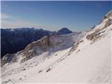 21
21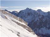 22
22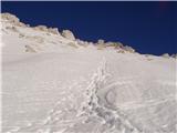 23
23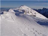 24
24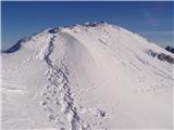 25
25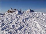 26
26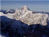 27
27
Discussion about the trip Vršič - Velika Mojstrovka (vzhodni vrh) (southern way)
|
| ROBERT22. 08. 2006 |
My first two-thousander!! Great tour!
|
|
|
|
| Gost5. 02. 2008 |
And how is it in winter, when there is no more avalanche danger?
Best regards, Franci
|
|
|
|
| Gost6. 02. 2008 |
This is a great winter tour, quite steep in places, I recommend skis, crampons and ice axe.
|
|
|
|
| Reny5. 09. 2008 |
I was there this summer, but apparently on another slightly easier path, because there were no safety gear... A bit higher we turned left and zigzagged up the steep slope with a few climbing steps and then to the summit.. well, I was up there. But above the scree it's already quite worn path! Down via scree, wheee! But not in winter! well, I was up there. But above the scree it's already quite worn path! Down via scree, wheee! But not in winter!
|
|
|
|
| heinz3. 07. 2011 |
In the valley between the two Mojstrovkas there are cairns leading too far left; I think to Suh vrh. Head to the scree under the wall of V. Mojstrovka and follow the path across the scree to the cliff on the right, by which (pic 13) turn right. Straight up to the ridge is possible too, but the scree is even more strenuous there. Otherwise the path isn't too demanding.
|
|
|
|
| nevi23. 09. 2011 |
Is it difficult to go directly from Mala Mojstrovka to Velika?
|
|
|
|
| Domch21. 11. 2011 |
On Saturday it was beautiful there. Warm and nice views. The trail at the exit from the scree is covered with corn snow, but the tracks are well trodden and deep enough, so no major problems for ascent and descent.
|
|
|
|
| gorenjka121. 11. 2011 |
Yesterday we traversed the Mojstrovka ridge to Travnik. Snow on the entire trail posed no major problems, the lower trail back to Vršič below the ridge is completely dry. Alone on the entire trail, angelic weather and boundless views 
|
|
|
|
| Marky16. 01. 2012 |
Nice Saturday weather and ideal conditions attracted quite a few people to the mountains on Saturday, including me
The path from Vršič over Mala to Velika Mojstrovka is very popular (on Saturday there were at least about 30 people up there if not more, really mostly ski tourers). The track is made, the path is firm..
Pictures from my Saturday ascent can be viewed at M-foto.si
|
|
|
|
| bobby2. 07. 2012 |
There was already a question posted above, but I didn't notice an answer. If I want to go from Vršič at once to Mala and Velika Mojstrovka, how is this best done. Do I need to backtrack somewhere, or is a direct crossing possible, etc. Please, if someone could describe it a bit.. best regards
|
|
|
|
| čru6. 09. 2012 |
Marki, hats off for the pictures
|
|
|
|
| pupek23. 07. 2013 |
Hello!
I'm interested in what the conditions are like and what the difficulty is.
|
|
|
|
| Tinca56. 12. 2013 |
Mojstrovka on Wednesday 4.12., warm weather, windblown snow, nobody anywhere. You can drive to Koča na Gozdu by car. Nice that you don't meet anyone. At Erjavčeva koča, well-deserved refreshment.
|
|
|
|
| GWalker9. 05. 2015 |
Hi!
I'm interested in what the conditions on the path are like?
Best and thanks!
|
|
|
|
| Viper9. 05. 2015 |
At least to Mala Mojstrovka.
|
|
|
|
| SunBurned9. 05. 2015 |
Conditions on 8.5.: to Mala Mojstrovka completely without problems, towards Velika still all snowy and winter conditions.
|
|
|
|
| J.P.8. 08. 2020 |
I believe this path is even more beautiful in winter. But I agree with heinza's comment above, the path here in the pictures veers quite to the left, but there is a nice trodden path to the right where almost at the top we join the wall of V.Mojstrovka and after a few moves reach the summit itself. The path from Vršič is shorter and I recommend descent from Mala to Velika Mojstrovka or vice versa. Lp
|
|
|
|
| Lazo4. 09. 2021 16:55:34 |
Here's a video if anyone wants to see the path to Velika Mojstrovka and then the traverse to Mala Mojstrovka.
https://youtu.be/ndLKIWRZF08
Safe steps to all!
|
|
|
To post a comment you must log in:
If you do not yet have a username, you must first
register.