Starting point: Vršič (1611 m)
| Latitude/Longitude: | 46,4336°N 13,7435°E |
| |
Walking time: 2 h 15 min
Difficulty: difficult pathless terrain
Elevation gain: 498 m
Elevation difference along the route: 600 m
Map: TNP 1:50.000
Recommended equipment (summer): helmet
Recommended equipment (winter): helmet, ice axe, crampons
Views: 16.842
 | 3 people like this post |
Access to starting point:
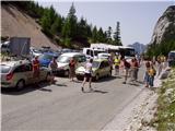
From Kranjska Gora we drive towards Bovec or vice versa, but only to the Vršič pass, where we park.
Route description:
From the parking lot at the Vršič pass we head onto the initially poorly marked path that leads to Mala Mojstrovka and Slemenova špica. After a short ascent the path takes us to a larger rock on which we notice the inscription Mojstrovka to the left. We continue in the direction of Mojstrovka (to the right Mojstrovka via Hanzova pot and Slemenova špica) along the path that ascends transversely through sparse larch forest. After approximately half an hour of ascent the path brings us to an extensive scree slope below Mojstrovka. We cross the mentioned scree slope on the upper side, after which the path takes us into a crumbly gully. This is followed by a steep and dangerous for slipping ascent on scree, which we cover in about 15 minutes. At the top of the gully the steepness eases and the "sunny" coastal side opens up before us. Here the path turns right and after just a few steps begins to ascend steeply (danger of slipping in snow and ice!). At the top of this ascent we step onto a beautiful viewpoint, from which a nice view opens down towards Vršič. The path ahead moves away from the ridge slightly to the left and then crosses two smaller gullies.
A little further on we leave the marked path to Mala Mojstrovka and head left, slightly downhill into the small valley between Mala and Velika Mojstrovka. From here we can already see our goal well, which we approach via easier off-trail (we see it slightly to the left). The closer we get to Suhi vrh, the steeper it looks. When we reach the foot of Suhi vrh, on its right (northern) side, we have two options for continuation. The orientationally easier but technically more demanding path (climbing 2nd degree) will lead us along the steep ridge straight up, all the way to the summit. The other easier one leads us from the north wall downhill, then we keep slightly left until a scree slope opens up below Suhi vrh. Next we climb up the scree slope, which brings us to the ridge from which we could have come if we had ascended to the summit via the direct path. From here to the summit we still have about 5 minutes of steep ascent with climbing up to 1st degree.
Vršič - Vratca pod Mojstrovko 1:00, Vratca pod Mojstrovko - Suhi vrh 1:15.

Along the route: Za Šitom (1760m), Pod Vratci (1895m), Vratca pod Mojstrovko (1941m), Odcep z markirane poti (2033m)
Photos:
 1
1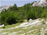 2
2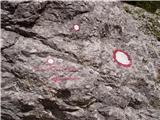 3
3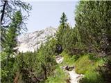 4
4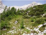 5
5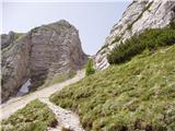 6
6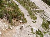 7
7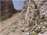 8
8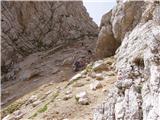 9
9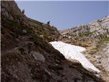 10
10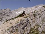 11
11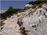 12
12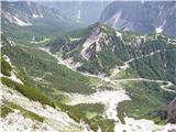 13
13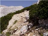 14
14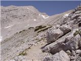 15
15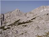 16
16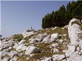 17
17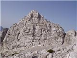 18
18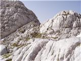 19
19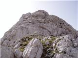 20
20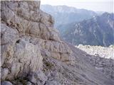 21
21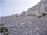 22
22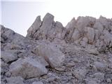 23
23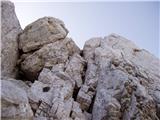 24
24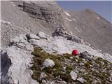 25
25
Discussion about the trip Vršič - Suhi vrh
|
| ločanka4. 08. 2015 |
Wonderful world, peace and solitude! Summit worth repeating!
|
|
|
|
| J.P.21. 06. 2021 21:03:30 |
Great description. Regards
|
|
|
|
| dominikfly6. 03. 2025 01:01:07 |
Hidden treasure in the heart of the overcrowded Mojstrovke. For lovers of wilderness and solitude, just a stone's throw from Vršič. Searching for passages to the summit is pure pleasure, if we stick to the ridge on the right, we can find even some higher degree than II, of course in that case wisely.
|
|
|
To post a comment you must log in:
If you do not yet have a username, you must first
register.