Vršič - Mala Mojstrovka (via Šitna glava)
Starting point: Vršič (1611 m)
| Latitude/Longitude: | 46,4336°N 13,7435°E |
| |
Route name: via Šitna glava
Walking time: 2 h 15 min
Difficulty: easy unmarked way, difficult marked way
Elevation gain: 721 m
Elevation difference along the route: 730 m
Map: TNP 1:50.000
Recommended equipment (summer): helmet
Recommended equipment (winter): helmet, ice axe, crampons
Views: 62.967
 | 2 people like this post |
Access to starting point:
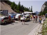
From Kranjska Gora we drive towards Bovec or vice versa, but only as far as the Vršič pass, where we park.
Route description:
From the parking lot at the Vršič pass we head onto the marked path in the direction of Mala Mojstrovka and Slemenova špica. The path quickly splits, and we choose the left path towards Mala Mojstrovka (right is Slemenova špica and Hanzova pot to Mala Mojstrovka). This is followed by a traversing ascent to the left, where we first go through a belt of shrubs, then we arrive among dwarf pines and a sparse larch forest, through which a wide, mostly stony path leads. After about half an hour of ascent, we reach a larger scree slope, where an unmarked path branches off to the right to Šitna glava, while straight ahead the marked path continues towards Mala Mojstrovka.
We continue the ascent along the unmarked path, which leads us in a slight traversing ascent to the right towards the slopes of Šitna glava. The relatively well-visible trail soon brings us to an indistinct little valley between Mala Mojstrovka and Šitna glava. Here the path turns slightly left and ascends a bit more steeply on an increasingly rocky slope. When the path gets quite close to the summit, it turns right, crosses a partially overgrown scree and then climbs to the grassy summit of Šitna glava.
From Šitna glava we continue along the ridge towards the west, first slightly downhill, then uphill in the direction of Mojstrovka (unmarked). The poorly visible trail along which we continue to ascend brings us after a good 20 minutes of walking from Šitna glava to the place where we join the Hanzova pot to Mojstrovka, which we reach above a very demanding section.
Further on, orientation is easier, the path becomes increasingly steep. After a few more minutes the steepness eases and the path brings us to a flatter terrain, which we bypass on the right side. Further on, the path approaches the ridge, and we see Mangart and Jalovec in front of us. Here the path turns slightly left and brings us to the next steep section, where with the help of a few pitons, mainly without protection, we climb the steep summit slope of Mala Mojstrovka to its panoramic summit. In the last part of the path there is especially in wet conditions a danger of slipping, while in dry conditions the path does not present a major obstacle.
Vršič - fork from the marked path 0:35, fork from the marked path - Šitna glava 0:45, Šitna glava - Edge of the north wall of Mala Mojstrovka 0:20, Edge of the north wall of Mala Mojstrovka - Mala Mojstrovka 0:35.

Along the route: Za Šitom (1760m), Odcep z markirane poti (1825m),
Šitna glava (2087m), Rob severne stene Male Mojstrovke (2116m)
Photos:
 1
1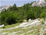 2
2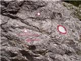 3
3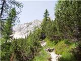 4
4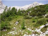 5
5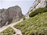 6
6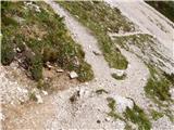 7
7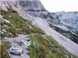 8
8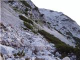 9
9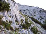 10
10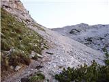 11
11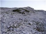 12
12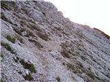 13
13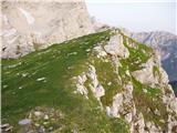 14
14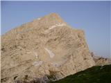 15
15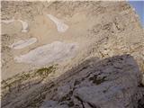 16
16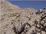 17
17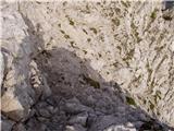 18
18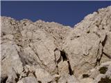 19
19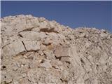 20
20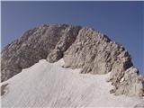 21
21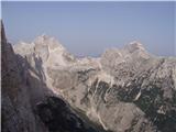 22
22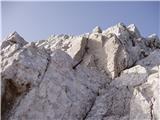 23
23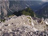 24
24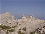 25
25
Discussion about the trip Vršič - Mala Mojstrovka (via Šitna glava)
|
| Klin31. 07. 2008 |
Today I went along the described path, which is really nice and much quieter than the usual one. I extended the trip with a visit to Travnik and Velika Mojstrovka. But the weather wasn't the best today.
|
|
|
|
| nekdo131. 07. 2008 |
Can you tell me what the ridge from V. Mojstrovka to Travnik is like?
|
|
|
|
| Klin31. 07. 2008 |
I didn't continue along the ridge. From V. Mojstrovka I descended about 200 vertical meters and continued on the path that crosses the slopes from Mojstrovke to Šita. When a nice passage to Travnik opens on the right, I left that path and climbed to the summit without major difficulties. The hardest part for me was on the crossing path, where I had to climb a 5-min. steep scree slope.
|
|
|
|
| Jan2310. 08. 2014 |
Today we took this route and descended via the southern direction. It's true that the path via Šitna glava is nice and calmer than the usual one, but the steep section requires a bit of scrambling
|
|
|
|
| trdi21. 08. 2017 |
Here, in the description, besides the easy unmarked path, it also mentions a demanding marked path, but it would be good to note this also in the main menu when searching for Mala Mojstrovka, as this path joins Hanzova on the ridge, which from the ridge is not as demanding as below, but you still have to do some climbing and it is definitely not an easy unmarked path, as someone might think.
|
|
|
|
| grega686. 08. 2018 |
For me the most beautiful path to MM. But it's demanding.
|
|
|
|
| steleu18. 10. 2018 |
Can the path from Nad Šitom glave to the summit of M. Mojstrovka be compared in terms of exposure and difficulty, say, to the path to M. Draški vrh from Srenjski preval?
|
|
|
|
| michael6618. 10. 2018 |
The path to Mojstrovka is more exposed than to mdv, but it's marked and secured when we join Hanzova (well, the pegs are better for reference). It's not crumbly like on mdv, where you have to damn well watch what you grab.
|
|
|
|
| djimuzl18. 10. 2018 |
And from Mojstrovka you can choose the easier southern path for the descent.
|
|
|
|
| Kanjanez20. 07. 2019 |
I would rename the trail to partially demanding; due to steep scree slope, rocks (before reaching the saddle visible from Vršič).
YES, you can choose circular = same starting point.
|
|
|
|
| georgia27. 07. 2019 |
We walked the trail this week. To Šitna glava without problems, same to the junction with Hanzova, nothing special.
Further on - you walk or climb all the way to the top on the unprotected section of Hanzova trail, exposed! There are only a couple of pegs and a few markings in total, so we guessed several times where to climb through the wall, straight, left or right? No markings or those red dots showing the route through the rocks, where you really need them if you're here for the first time! A few really awkward spots... We luckily made it to the top, down via the easiest trail.
On this trail - met a huge number of tourists in sneakers, even with smooth soles, which are for the city and not for the mountains, let alone such trails!!! They were slipping already on the way up, the path through the notch was catastrophic because of such views and dislodging stones... 
We warned someone about inappropriate footwear, as he was slipping on the way up, but he just thanked and continued anyway. How he and others similarly shod (some with children in carriers) even got up and down, I don't understand. Obviously they have more luck than sense...  Still, we chose a shortcut through the scree and hoped no one triggers a stone on us. Great shortcut! Still, we chose a shortcut through the scree and hoped no one triggers a stone on us. Great shortcut! 
|
|
|
|
| Enka14. 07. 2020 |
Do I understand correctly that we join the Hanzova trail above the secured section? Only that upper part to overcome, where it's not secured (not counting those two or however many pitons)?
|
|
|
|
| pikica114. 07. 2020 |
You understand correctly @Enka. This trail via Šitna glava is the most beautiful approach to Mojstrovka. Regards.
|
|
|
|
| Enka14. 07. 2020 |
Thanks pikica! I've been on all these paths already, just haven't connected Šitna glava with M. Mojstrovka yet
|
|
|
|
| ajo6220. 07. 2020 |
If Hanz's path is currently closed due to maintenance work, I'm interested if the upper part (where it joins the path connecting the top of Šitna glava) is still passable. Thanks.
|
|
|
|
| Daaam20. 07. 2020 |
Writing from memory but I think it should be normally passable.
|
|
|
|
| djimuzl20. 07. 2020 |
On the PZS website trail map (Trail Conditions), the final section of Hanz's Trail - above Šitna glava and Mala Mojstrovka - is also "under processing".
|
|
|
|
| masker13. 09. 2020 |
Today I repeated the ascent to Mala Mojstrovka after a one-year break. Originally headed to Hanzijeva, but due to the crowd in the wall, I abandoned the original plan and instead returned to the starting point at Vršič and from there continued up the southern path to the junction for Šitna glava. Definitely a nice variation on the theme of easy pathless terrain. But it is not entirely "innocent" either. The descent through the scree is still quite tricky. Congratulations to the maintainers of the mountain paths for installing a belay point just below the saddle, where you can descend safely without dislodging rocks or slipping......bravo!!!
|
|
|
To post a comment you must log in:
If you do not yet have a username, you must first
register.