Vrbiški dol - Koča na Kozleku
Starting point: Vrbiški dol (820 m)
| Latitude/Longitude: | 45,5599°N 14,2977°E |
| |
Walking time: 1 h
Difficulty: easy marked way
Elevation gain: 177 m
Elevation difference along the route: 250 m
Map: Snežnik 1:50.000
Recommended equipment (summer):
Recommended equipment (winter):
Views: 14.782
 | 1 person like this post |
Access to starting point:
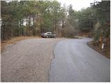
From the highway Ljubljana - Koper, take the Postojna exit and follow the road ahead in the direction of Reka and Ilirska Bistrica. In Ilirska Bistrica, the road towards Sviščaki branches off sharply to the left. We continue driving towards Sviščaki and park on the parking lot at the road marker between 7.5 and 8 km.
Route description:
From the parking lot, we continue on the road ahead, which after 50 m brings us to the mountain signposts for Kozlek. Here we continue right slightly downhill on the macadam road, which we follow for a good 10 minutes to the spot where the path to Kozlek branches off to the right. The well-marked path towards Kozlek soon turns and starts ascending. Only a little further, the path from the village Jablanica joins us from the right. Further on, we continue on the path, which moderately ascends along a forest-covered ridge. Soon we come to panoramic slopes from which a beautiful view opens towards the south, and towards the east we already see the panoramic Srednji vrh, which is the forepeak of Kozjek. Here the path descends for a short time, then brings us in a moderate ascent through the forest to Srednji vrh.
From Srednji vrh, the path slowly descends to the saddle between the two peaks and then starts ascending again, first on an unvegetated slope and higher through the forest. When we reach the Koča na Kozleku, a view opens towards the south and east. From the hut to the top is only a few steps of easy walking.

Photos:
 1
1 2
2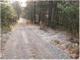 3
3 4
4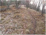 5
5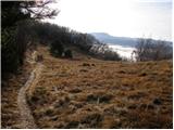 6
6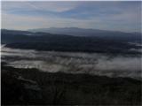 7
7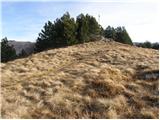 8
8 9
9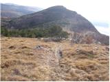 10
10 11
11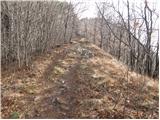 12
12 13
13
Discussion about the trip Vrbiški dol - Koča na Kozleku
|
| pohodnica5316. 04. 2009 |
Is the hut already open on Saturdays and Sundays?
|
|
|
|
| marco16. 04. 2009 |
Hut on Kozlek is open on Sundays and holidays.
It operates on a duty roster principle, arranged within the Planinska sekcija Podgora, and according to my information, the hut operated all winter too (except in bad weather conditions).
Information: 040 867 248 (Majk)
|
|
|
|
| pohodnica5320. 04. 2009 |
thanks marco for the info; so we won't suffer too much thirst when we get up there, hehe....
|
|
|
|
| bprinc5. 10. 2017 |
We walked from the parking lot along the gravel road for 30 min and then reached the junction for Kozlek, where the path goes right uphill. From that junction to the hut is another 25 min. This note on hribi.net is no longer accurate, because the path doesn't look like that anymore.
Otherwise, a nice and pleasant trip.
|
|
|
|
| Enka8. 06. 2019 |
The description is completely OK and still valid. But you need to keep your eyes open so you don't miss the junction from the description (the path and markers are clearly visible, the sign is somewhere high on the tree  ). ).
|
|
|
|
| trdi2. 01. 2022 22:41:46 |
Super ridge path, the description is correct, nice winter tour...
|
|
|
To post a comment you must log in:
If you do not yet have a username, you must first
register.