Vranček - Veliki vrh (Košuta) (climbing way)
Starting point: Vranček (950 m)
| Latitude/Longitude: | 46,4279°N 14,2726°E |
| |
Route name: climbing way
Walking time: 3 h 10 min
Difficulty: very difficult marked way
Elevation gain: 1138 m
Elevation difference along the route: 1160 m
Map: Karavanke - osrednji del 1:50.000
Recommended equipment (summer): helmet, self belay set
Recommended equipment (winter): helmet, self belay set, ice axe, crampons
Views: 70.832
 | 4 people like this post |
Access to starting point:
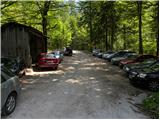
From the highway Ljubljana - Jesenice, we take the Ljubelj exit and follow the road ahead towards the border crossing. When we leave the last tunnel (we recognize it by the fact that after the tunnel on the left side of the road there is scree), in the first sharp left turn we will notice a road house and next to it a macadam road. Here we park on a smaller parking lot or we drive on a bad road further to the next parking lot, which is situated a little higher.
Route description:
From the parking lot, we go on a bad forest road and follow it ahead. The road higher crosses a torrent, after that slightly ascends and then brings us to the spot where it ends. Ahead we cross the bridge and continue on a cart track which is moderately ascending on a partly overgrown scree. The cart track makes a few sharp turns and brings us from the northern slopes of Košuta to the southern slopes of Košutica.
Further, we are mostly ascending through the forest, which brings us to a larger clearing. Here the cart track goes sharply left and ascends towards the mountain pasture Korošica. A little before the mountain pasture we cross a grazing fence, where a beautiful view opens up. From the meadow we go slightly right below the cottage, which we see above us. The path then turns left and in a few steps of ascent brings us to the cottage on the mountain pasture Korošica.
From the mountain hut, we go right in the direction of Veliki vrh towards Hajnževo sedlo. The path ahead crosses the slopes of Košutica mostly in a gentle ascent through an increasingly thin forest. We follow this path, which becomes increasingly panoramic, to Hajnževo sedlo, where the path from Austria joins.
On the saddle, we go right towards the south in the direction of Veliki vrh (left Košutica). Already after a few meters of additional walking, we enter the climbing part of the path, which is technically demanding, and the path is exposed to falling stones. In wet conditions this part of the path is very dangerous for slipping. When we exit the climbing path, we have only a few minutes of walking to the top on the panoramic upper slope of Veliki vrh.
Starting point - Korošica 1:35, Korošica - Veliki vrh 1:35.

Photos:
 1
1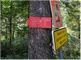 2
2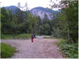 3
3 4
4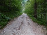 5
5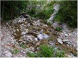 6
6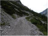 7
7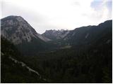 8
8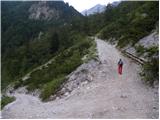 9
9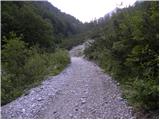 10
10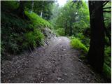 11
11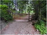 12
12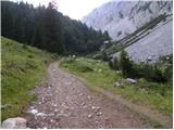 13
13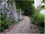 14
14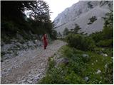 15
15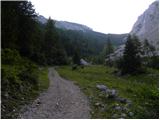 16
16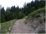 17
17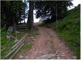 18
18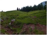 19
19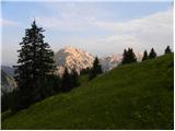 20
20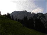 21
21 22
22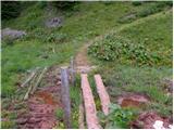 23
23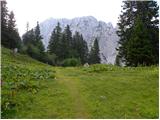 24
24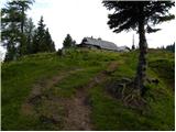 25
25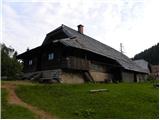 26
26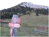 27
27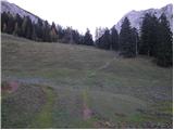 28
28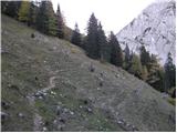 29
29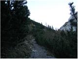 30
30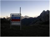 31
31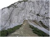 32
32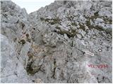 33
33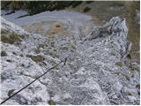 34
34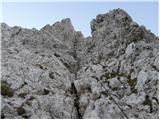 35
35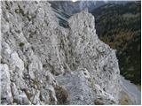 36
36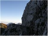 37
37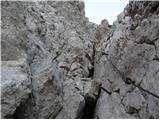 38
38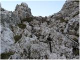 39
39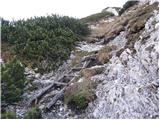 40
40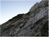 41
41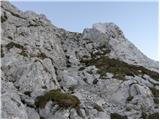 42
42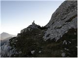 43
43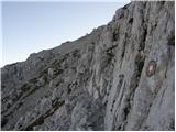 44
44 45
45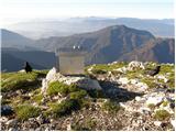 46
46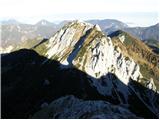 47
47
Discussion about the trip Vranček - Veliki vrh (Košuta) (climbing way)
Show older messages
|
| Gost31. 03. 2007 |
Can you also climb up from Planina Kofce?
|
|
|
|
| Gost31. 03. 2007 |
Of course, it is possible.
|
|
|
|
| Gost1. 04. 2007 |
Yes, and it's even more of a walking path! 
Well, at least it's not climbing nor airy, but I don't recommend it at all in this season!
|
|
|
|
| Gost1. 04. 2007 |
This description inappropriately talks about pathless terrain. Paths are clear and at least from Hanževo sedlo onwards also marked. Regarding difficulty, no need to exaggerate. I led a Dane (fit) who was first time in these mountains up and down to Kofce. No problems. It's a nice tour from Ljubelj to Matizovec. Just need two cars. LP Vojko
|
|
|
|
| Gost2. 04. 2007 |
You mixed up a bit. No comparison for both paths to Veliki vrh from Kofce or Hanževo sedlo. From Kofce beautiful tour in this season (not walking though), from Hanževo sedlo in this season demanding winter ascent, does anyone even tread it.
|
|
|
|
| Gost8. 11. 2007 |
super super....although a bit difficult in the snow but in the end well deserved
best regards
|
|
|
|
| andrej jerina23. 06. 2008 |
I also did the mentioned trail to Veliki vrh today. The trail is well marked in good weather, but in fog there can be problems. Insurance is in good condition, rock is good, just a lot of scree on the trail, so caution. I think a helmet on this trail is quite mandatory, at least from my side, because several things flew down today. In short: short, tense at the beginning but not too demanding and partly nicely airy trail. Best, Andrej
|
|
|
|
| Sam.volk23. 08. 2008 |
My wife and I hiked the path on 18.8.08. To the Korošica pasture and further to Hajnževo sedlo, normal hiking path. Right from the saddle, the secured climbing path continues. It requires quite some caution. The second part of the path is quite annoying due to scree. The summit has nice views. We returned the same way, which required a lot of caution. Overall rating, nice tour. Regards Franc
|
|
|
|
| NEIC00830. 08. 2008 |
The trail is no small feat.. The first part is quite steep climbing trail requiring considerable strength also in arms, the second part also steep but undemanding trail. Not for the vertiginous!!
|
|
|
|
| jersy6. 09. 2008 |
this trail I plan to do in case of nice weather...where can you get back to Vranček?
thanks for answer
|
|
|
|
| Tadej6. 09. 2008 |
There is no circular path, unless you're willing to walk one hour on the road back to the starting point.
Possible descent to Kofce, from there via Matizovec to the main road leading to Ljubelj (the main road has an old parallel one by which you can climb back to the start).
|
|
|
|
| micmic10. 09. 2008 |
If you enjoy walking on scree, on the return along the same path, as soon as you descend from the "wall" to Hajnževo sedlo, it's worth turning left and continuing on the path that winds along the top of the scree. When you reach above the path leading to the valley, then YEEHAW down the scree.
|
|
|
|
| ben10. 06. 2009 |
Nice greeting!
Does anyone know what the condition of the path is like, especially if there's still any snow on the path?
Thanks in advance
|
|
|
|
| ana21. 06. 2009 |
Today we went along the described path, no snow, fixed protection in order.
|
|
|
|
| Bojan_A10. 08. 2009 |
Good thing I decided on this variant today instead of various Begunjščice and Stoli.
To Planina Korošica, I ran along the road, although it was difficult because of the scree. The shortcut to Hanjževo sedlo is very fast - running. On the way to Veliki vrh I trained running on the climbing path (in my mind running to Triglav). It surprised me how steep and sometimes exposed it is. But uphill without problems. Downhill I was much more careful and there was no possibility to run. The fixed protections are okay, except for two loose pitons.
From Hanjževo sedlo I treated myself to a short hop to Ljubeljska Baba (Košutica). Back to Planina Korošica I didn't feel like running, so I cut the path along a very neglected hunting trail through the dwarf pines. Then I was quickly at the car via shortcuts.
Very nice tour.
|
|
|
|
| lepenatka10. 06. 2010 |
Hi, has anyone hiked these days to V. Vrh via Hajnževo sedlo?
How is it with snow and the condition of fixed protections?
Thanks for the reply.
G
|
|
|
|
| lepenatka10. 06. 2010 |
Thanks and I wish you safe steps.
|
|
|
|
| robter19. 07. 2010 |
With my 15-year-old son I went up on 13.7.2010, in beautiful weather.
From the roadman's hut to Hajnževo sedlo 1:25, without stopping at Korošica. Then another 45 minutes to the summit.
Helmet use is recommended.
Then we headed to Kofce and via Kala, Završnik, Pirmanc and Kamnek all the way to Tržič.
|
|
|
|
| 5Xum3. 05. 2011 |
Does anyone know what the current conditions are on the climbing section of the trail? Since it's the north side, I assume it's still snowy?
|
|
|
|
| JusAvgustin3. 05. 2011 |
You're correctly predicting... with the right equipment you can also approach from the north side now. Generally the rule holds to go into north walls in July, when (generally) everything is snow-free!
|
|
|
|
| Fric31. 05. 2011 |
Beautiful trail. Passed on Sunday 29.05.2011. Gorgeous weather, exceptional views! Snow all the time from Korošica. I don't know, the part through the rocks seems much harder to me than e.g. through "žrelo" on Storžič or the northern approach to Raduha, although the path description doesn't say so. Probably mostly experienced hikers go here. The biggest problem is at the summit part where there is no protection, so on icy snow, definitely not without crampons and ice axe, but now it wasn't a big problem. Returned the other side via Kofce. Nice hut, excellent food, fast service, as befits Slovenian huts, and with gorgeous weather and views like from ads, what to say, perfect. Photos on www.pk-ivanec.hr!
|
|
|
|
| zdomec31. 05. 2011 |
Fric, your photos cannot be seen on www.pk-ivanec.hr.
Did you maybe provide the wrong address???
greetings
Zdomec
|
|
|
|
| garmont28. 06. 2011 |
Today walked the above-mentioned path in both directions. Given that the markers recently installed a new wooden ladder on the path (meaning there was a work action), I missed the renewed Knafelčev markers and ground direction lines, as the path in the summit section is quite hard to follow. This applies especially to the ridge section of the path.
Best,
|
|
|
|
| brarut10. 07. 2011 |
Yesterday 9.7.2011 we hiked the trail in both directions. Beautiful weather but on the saddle there was a strong cold wind blowing, which accompanied us also in the wall, especially blowing the last part of the trail towards the summit when walking along the ridge. After descent to the saddle still a jump to Košutica, and buckwheat dumplings with sour milk at Planina Korošica. Very nice hike that is not overly demanding.
|
|
|
|
| Manyana28. 08. 2011 |
Today I did a circular route with descent to Kofce (Matizovec). Very nice hike, as a climbing route it is not very demanding, the actual climbing part is very short, but the path markers could repair the loose pegs (the chains are in good condition, but I counted quite a few loose pegs - good thing in dry weather they are not really necessary).
|
|
|
|
| folpo10. 09. 2011 |
circular tour Podljubelj-Korošica-Košuta-Košutica-Pod Ljubelj; climbing section really short, view fantastic, stones flying from all sides (to Košuta after climbing section)
|
|
|
|
| petruša11. 06. 2012 |
Hello, I'm wondering if self-protection is needed here (taking kids aged 13 and 14), is it harder than to Peč via climbing path. We've already hiked many climbing paths. So wondering if we should take it along or no need. regards
|
|
|
|
| ljubitelj gora11. 06. 2012 |
I went on this path recently, protections ok, dry, if you're not sure then take it with you, it's only about half a kilo anyway.
|
|
|
|
| irska18. 08. 2012 |
Since yesterday a new summit logbook at the top! The fixed protections, including those few loose pegs, are still holding. But there is really a lot of loose rock!
|
|
|
|
| NEIC0089. 09. 2012 |
After a long time today up again.. Does this short section of the path (right after the end of the first part of the climbing path) really not bother anyone, unprotected, the path running along the edge of a ''precipice'' with lots of scree on the path and high risk of slipping (at least for me). Back very very tricky crossing or descent..
|
|
|
|
| Domch2. 10. 2012 |
Was up there 22.09.2012. Nice tour with lots of animals on the path (chamois, horses, squirrels, jackdaws, ...). Planina Korošica really has a nice idyll. The climbing path is short and steep, the safety gear is impeccable. But I agree with the predecessor that it could be secured there, there's a lot of loose small stones on the path and if descending this path you have to be very careful. Better option is, if logistics allow, to do a circular tour down to Kofce and Matizovec. There was also snow below the summit, so additional caution was needed, otherwise nice view and warm weather.
|
|
|
|
| jprim4. 10. 2012 |
I agree with what NEIC008 wrote, ...
in my opinion, the route description header should be slightly corrected,... namely, it says climbing route and then just difficult, these don't go together, and protection can also be added, since someone who doesn't know the route doesn't know what to expect. From the description, one can easily take the route as too easy.
Regards!
|
|
|
|
| Domch4. 10. 2012 |
The route is climbing and therefore definitely very difficult, it is similar to the one on Peca only more crumbly. Helmet definitely yes, self-protection at own discretion.
|
|
|
|
| jax4. 10. 2012 |
Domch
4.10.2012 The route is climbing and therefore definitely very difficult, it is similar to the one on Peca only more crumbly. Helmet definitely yes, self-protection at own discretion.
Yes, and besides, unlike Peca there is no other descent to the starting point and you have to go back the same way. And the descent can be even more problematic than the ascent.
|
|
|
|
| Domch5. 10. 2012 |
The descent is problematic mainly on the part where there are lots of scree and no protection, that spot is between the two sections of protection. Descent to Kofce is possible but much longer walk.
|
|
|
|
| jprim5. 10. 2012 |
I suggest to the moderator to correct those data in the route description header.
The route is more difficult than on Peca, but otherwise in the same difficulty group of climbing routes
Regards!
|
|
|
|
| NEIC0085. 10. 2012 |
It's not exaggeration but facts. I've tackled many (at home and abroad) ''very demanding'' paths, and many are significantly easier than the mentioned path to Veliki vrh.
|
|
|
|
| urbancek5. 10. 2012 |
There are a sea of such or other "anomalies" in difficulty ratings in Slovenia, because the old classification was wrongly set up, so it's pointless to discuss it (until new and uniform difficulty ratings are introduced). Often, an individual's subjective view is involved here, which has no place in objective difficulty assessment. Thus, in my opinion, according to this old and misguided classification, "demanding marked path" is quite an appropriate label for this path. Of course, given that the highest difficulty level in the old system was "very demanding marked path"...
|
|
|
|
| NEIC0085. 10. 2012 |
NEIC008
11.8.2012 Hm hmP Why is this path classified as very demanding?? Very disappointed, because today's hike along the ''very demanding route'' was a complete disappointment. I would rate the path as demanding at most, the only thing that is ''very demanding'' is the drive to the parking lot and back home.
Above is my comment on the ''very demanding'' path to Peča. Personally, for me, no comparison. The path to Veliki vrh is definitely more demanding.
|
|
|
|
| jprim5. 10. 2012 |
@urbanček
I'm not exaggerating, but just comparing and reading ... and I still stand by what I wrote above.
Best regards!
|
|
|
|
| PREDO19. 06. 2013 |
Nice greetings!
I'm interested if maybe someone has recently walked this path and what the condition is regarding snow, fixed protection..?
Thanks!
|
|
|
|
| trk19. 06. 2013 |
I walked the path on 15.6. this year, no snow, fixed protection ok (2-3 pegs a bit loose so be careful. Careful also where not protected, because there is a lot of scree on the path.
|
|
|
|
| Janiel7423. 06. 2013 |
Yesterday walked this path...the path is even described in the book 55 protected climbing paths...really don't know by what criterion (they don't seem uniform to me) here no self-belay set is recommended...I went without anyway, but still...
|
|
|
|
| DARINKA529. 07. 2013 |
Yesterday I walked this path to the top and back the same way. Where there are no fixed protections it's a bit awkward, after a larger part of the path there is a very high risk of falling stones, so don't go there without a helmet.
|
|
|
|
| ms_primoz7. 10. 2013 |
on Saturday I was up there... the climbing part surprised me, the ridge surprised me, walking on all fours surprised me... in short, in very strong wind everything can surprise you 
PD Tržič - the three pegs up there are just for decoration - God forbid relying on them as holds...
the others will need to go up in sunny weather to have a real assessment of the ascent to Veliki vrh
|
|
|
|
| Domch10. 10. 2013 |
The climbing section is in the range of Pece, just more crumbly terrain. You caught wind and fog and kudos for persisting to the summit. The ridge in normal conditions is nothing special, but in such conditions or snow like we had last year, it's much riskier and adrenaline and fear do their thing. Otherwise a nice tour with good views.
|
|
|
|
| katja8719. 10. 2013 |
Yesterday, 18.10.2013, we did a circular tour: Vranček - Planina Korošica - Košutica (western path) - Hajnževo sedlo (via the eastern path from Košutnica) - Veliki vrh (via ferrata path) - Kofce - Matizovec - Podljubelj.
The weather was sunny, cloudless, so the views were fantastic
The via ferrata path to Veliki vrh is somewhat more demanding than we expected based on the photos and description. We are used to via ferrata paths, but for those who aren't, it can be problematic. Also, it's not mentioned anywhere that part of the upper path is a ridge, which can be a problem for those afraid of heights. The via ferrata set is also not mentioned anywhere, although there are quite a few cables in the lower part, so I recommend it to everyone who is not 100% sure. The upper part of the path is mostly free climbing.
Despite the incomplete description, we found the path great and will gladly go up here again I recommend to everyone to bring a helmet obligatory, as the path is quite crumbly
You can see photos from the hike on the website of the Matica Murska Sobota Mountaineering Association: http://www.mojalbum.com/pdmaticams/20131018-kosutica-in-veliki-vrh-plezalna-pot/izhodisce-matizovec-in-se-zadnji-pogled-na-veliki-vrh/21190804
|
|
|
|
| 5Xum1. 11. 2013 |
Today I was up there, the path is in good condition, all pegs are in place, no snow for now.
|
|
|
|
| jelka10030. 05. 2014 |
what are the conditions like on the path??
|
|
|
|
| bavdy28642. 06. 2014 |
Does anyone know about the conditions??
|
|
|
|
| gandalf9. 06. 2015 |
Has anyone been from Hanževo sedlo to the top of Veliki vrh recently? I'm interested if there's any snow anywhere?
thanks
|
|
|
|
| velkavrh9. 06. 2015 |
gandalf, read the post by palčka plezalčka on the forum and you'll learn everything about the path from Hanževo sedlo to V. vrh.
|
|
|
|
| misace10. 06. 2015 |
4 June 2015 no snow, fixed ropes o.k. (slightly worn in two places), at the exit before the wooden shrub a "plug" of soil, be a bit careful. and watch out for snakes
|
|
|
|
| misace10. 06. 2015 |
I meant ladder
|
|
|
|
| gandalf10. 06. 2015 |
Thanks to both, I saw the description from palček plezalček. On Friday I plan to go check it out via Košuta then to the saddle and up
|
|
|
|
| Barentoter12. 12. 2015 |
What are the conditions like in the climbing section. Thanks!
|
|
|
|
| ivoma4. 06. 2016 |
Today walked the mentioned path, which is dry. Need to be careful on wet scree and mud on the path.
|
|
|
|
| magroman31. 07. 2016 |
After yesterday's return from the sea, the idea of a morning jump to Veliki vrh came immediately. Friend laid low with illness overnight, so I went alone. At 5:00 at the toll booth (raining to Podljubelj), wait another 15 min and head into the steep. Nice and fairly steep path, past the hut, to the saddle, then into the cables. Expected something worse, but nothing special. To summit 1h 50min. On descent the scree is a bit annoying, at saddle turn left immediately onto scree slopes which can be used very well. Join marked path and quickly to valley. Total 1h 25min. Lp
|
|
|
|
| CarpeDiem24719. 08. 2016 |
This looks like a fun climbing path and as I see not too difficult
|
|
|
|
| jax19. 08. 2016 |
It's nice, although a bit underestimated in this description, and quite crumbly too. A bit annoying because it's actually the only practical descent the same way, which can be unpleasant. Otherwise I agree - short, fun and not too difficult tour, though not to be underestimated.
|
|
|
|
| Ksandarela13. 06. 2017 |
Hello hikers
I have read all the comments about the crumbly wall and loose pitons, but they are already several years old... Please tell me what the current conditions on the climbing route are, if there is any snow given the north position, and how suitable this route is also for descent, considering that some in our group are still beginners in climbing... 
Thanks in advance
|
|
|
|
| garmont13. 06. 2017 |
For beginners, the descent will be quite difficult. On the exposed sections of the path there is quite a lot of scree, no protection there. On one section a rope helps, which someone tied there.
The protections are mostly okay, but there aren't many, who knows...
|
|
|
|
| Lunca15. 06. 2017 |
I would also advise against descent. Go with two vehicles, leave one at the starting point, the other at Matizovec, where you can descend, past the hut on Kofce.
|
|
|
|
| Ksandarela15. 06. 2017 |
Thanks for the reply
Lunca, interesting recommendation to go with two cars, because I was just studying how to manage this, to descend past the hut on Kofce... thanks smart owl
|
|
|
|
| Nastasja9. 07. 2017 |
Yesterday my friend and I were on this path. Personally, the rocks didn't seem crumbly to me, but it's true that some stones are loose and each one needs to be checked before grabbing or stepping. Some pitons were loose. For the climbing section, it's great if the hiker/climber has at least some climbing experience. We had no problems with the descent, but we have a lot of stamina and I also have experience. I also thought it would be ideal to drive with two cars to Matizovec, leave one car there and drive to Vranček. On the way back to Vranček around 12 o'clock we saw two adders on the path (I'm a layman in species identification). One was still on the climbing section, the other just below the saddle or state border. Both were younger and so fast that we couldn't even take a picture of them. They heard us because we were talking loudly and because I was the first using poles. If we watch our feet, there's no fear of being bitten by any, as they are really very shy. They come to the path because it's warm on the rocks.
|
|
|
|
| CarpeDiem24718. 07. 2018 |
Today we summited Veliki vrh also via this path and conditions are excellent (all protections in good condition, the mentioned rope is still there for assistance). Return preferably via the path past Kofce, so with two cars (the other at Matizovec) and thanks for the advice from people on this forum!
|
|
|
|
| Edina30. 08. 2018 |
I have recorded the current condition of the path under current conditions, but here, given the variety of the above records, I quote Stanko Klinar, who wrote the first guide to the Karawanks half a century ago, and the quote is at least twenty years old: "The path is one of the most demanding and scenically most varied in the Karawanks. It leads through mighty northern rock faces. It was secured and marked by SPD around 1930, and in 1982 it was thoroughly renovated by the Tržič markers." Even today it is not essentially different and it is right that it is marked as very demanding. I would add that the stated time of three hours is not in line for an average hiker. The mere fact that it involves almost 1200 meters of ascent, of which one third falls on the demanding section above the saddle, where you can't hurry if you don't want to trigger rocks, confirms my claim. Additional time is also required for self-belaying in the secured section. Of course, my regards to "magroman" and the like, who used a good three hours for up and down and even that on wet rock, as it was raining at the starting point according to his record. So, whoever spends half an hour more on the path and watches those climbing below him doesn't need to blush, but will celebrate the ascent on one wonderful Veliki vrh. Good luck on the paths to all; the fast, the average and also the slower ones
|
|
|
|
| Domch15. 10. 2018 |
The path is currently very littered with scree, muddy, greasy rocks in the middle part, 3 pegs are loose, two vertical ropes and blueberry branches provide assistance. Quite unpleasant up, very unpleasant down, if not dangerous for slipping.
|
|
|
|
| trdi28. 06. 2019 |
Wow, surprisingly demanding path due to objective danger. The entry section into the wall is super, at least while there are fixed ropes. Very awkward chimney higher up with dubious pegs, at the second rope almost suicidal ascent on steep unstable ground. Good thing there's that rope. From the chimney on there should be fixed ropes at least to the wooden ladder. From the wooden ladder on it's a nice ridge stroll with wonderful views. The lower part of the climbing path is definitely very demanding, helmet is essential, via ferrata kit is useless because there are no fixed ropes on the most difficult sections.
Descent to Kofce, in between there's also some rickety fixed rope with pulled-out pegs.
In short, PD Tržič in all its glory. I suggest they dedicate one weekend's earnings from Kofce to fixed ropes, then everything will be sorted...
|
|
|
|
| trdi2. 07. 2019 |
Well, I was just waiting for fatalities. Will inspectors fly here to close the path like on Komarča, which compared to this condition is a real gem? Oh, no tourists here...
|
|
|
|
| Majdag2. 07. 2019 |
Sad, the last ascent of the always cautious Janez Novak. Sincere condolences to the family..
|
|
|
|
| ločanka2. 07. 2019 |
This news saddened me too, as Janez was a faithful describer of his tours on this forum. In June he posted at least seven and thus enriched our list of current conditions for all of us.
May he rest in peace!
|
|
|
|
| Kamen4019. 09. 2020 |
The path is now exemplarily arranged. There are new fixed cables. I agree with predecessors, if possible go with two cars.
|
|
|
|
| AljaL9. 10. 2020 |
Hi, has anyone been on the climbing route these days? What's the condition like after the last snowfall?
|
|
|
|
| sla9. 10. 2020 |
Today from Hajnževo sedlo I saw that there is a little snow in the upper part.
|
|
|
|
| AljaL10. 10. 2020 |
There's just a sample of snow right below the summit. Can safely bypass it. Beautiful trail otherwise!
|
|
|
|
| zvehar14. 08. 2021 19:08:32 |
Today I was up there - nice tour, SVK not strictly necessary, but still recommend. There are some loose pegs in between and as predecessors wrote crumbly wall.
I also recommend extending the tour to Kofce and to the valley, as there is quite a bit of scree that can cause slipping. In this case it's advisable to go with two cars.
|
|
|
|
| Majdag15. 08. 2021 08:45:27 |
..The asphalt path back to Vranček is looong, checked far back..
|
|
|
|
| marko2210. 09. 2022 17:13:17 |
Today I was up there, from Vranček to Hajnžev via scree, which was unnecessary and strenuous. From the saddle along the fixed protections ok, but when I reached the ridge, I swallowed hard. On the way back it was easier, as I was more mentally prepared, but still used hands a lot. From the saddle via scree terrain! Up the path almost three hours, down two and 10. Helmet was very useful, as the person above me triggered rocks.
|
|
|
|
| garmont27. 09. 2023 14:10:01 |
The section of the path above the secured part, where there used to be a ladder (picture 40), has been replaced by made steps and is fully equipped with a steel cable.
|
|
|
|
| mj13027810. 04. 2024 17:19:43 |
hello, does anyone know if this route is already snow-free?
Thanks a lot for the reply.
|
|
|
|
| Darxta10. 04. 2024 19:36:39 |
mj, better to ask about this on the Razmere forum.
There look under the topic Karavanke -> Kepa. ljubitelj gora posted pictures 3 days ago, and on picture 13 on the left you can see the Košuta ridge from the north side. It's still quite white. It will probably be snow-free only in a couple of weeks.
LP
|
|
|
|
| anica.zu7. 10. 2024 19:55:02 |
The road workers' huts are no longer there.
|
|
|
|
| plaNinaPirsMajcen19. 06. 2025 19:25:59 |
Hi.
I made a little video about this beautiful path, invited to view:
https://youtu.be/zRuShVlOXPw?si=hpsBxgt7MapMWF36
For me personally the path is very beautiful, exemplarily secured, nowhere in the climbing section did I have a feeling of direct exposure. I used the self-belay kit only at the beginning, it didn't seem necessary to me though. Helmet definitely. The mentioned ridge also isn't anything special in good weather, wide enough, not crumbly.
Fairy-tale beautiful is Hajnževo sedlo with views to Slovenian and Austrian side, soft grass with flowers, real reward for approx. 800 elevation meters on a quite steep path from the starting point. Also beautiful is planina Korošica in between.
We descended to Kofce, for deserved štruklji and rest, then further to Matizovec, where ordered transport to the starting point was waiting for us.
Best, Nina
|
|
|
|
| mjk1. 08. 2025 08:10:17 |
The path is nicely secured, but there's a lot of loose scree piled up, especially above the wall. The problem is that it all rolls onto the path. Helmet mandatory. Via ferrata kit, and straight up, if you're going down this path and ever thought you need it on very difficult paths, especially if there's still snow (once you reach the scree you can stow the VK). It's lucky that the path is quite solitary, but that just means more buildup . 3h is more of a net estimate. The steepness eases to the saddle only on the path between the pasture and the saddle. Better to count 3.5h. After the wall and ridge it's 1:15, plenty ... Very nice path, with chamois already in the lower part to the pasture, well marked in the wall and on the ridge, especially lots of beautiful views. (I also avoided descent to Kofce). In my opinion not suitable for larger groups, because there's always someone who "whines".
|
|
|
To post a comment you must log in:
If you do not yet have a username, you must first
register.