Starting point: Vlačno (620 m)
| Latitude/Longitude: | 45,703°N 14,2525°E |
| |
Walking time: 1 h 20 min
Difficulty: easy marked way
Elevation gain: 486 m
Elevation difference along the route: 486 m
Map: Snežnik 1:50.000
Recommended equipment (summer):
Recommended equipment (winter):
Views: 47.054
 | 2 people like this post |
Access to starting point:
From highway Ljubljana - Koper we go to the exit Postojna. We follow the road ahead in the direction of Ilirska Bistrica but only to the village Pivka. In the middle of Pivka, a road branches off sharply to the left towards the village Trnje. We follow this road through the village Trnje and further to a crossroad near the military area, where we continue right. Further, we drive only approximately 100 meters to the parking lot by the road which is situated only a few meters before a smaller crossroad (a worse forest road branches off to the right).
Route description:
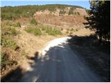
On the other side of the road, we notice a cart track beside which stands an unfortunately fallen sign with the caption Sveta Trojica 1h 20min. The path is at first ascending gently on panoramic grassy slopes from which a beautiful view opens up on the Pivka valley and surrounding hills. The path then goes into the forest, where it ascends gently. After some time, the path brings us to a cart track, where the path from a higher starting point (Sevski forest) joins. The path ahead is moderately ascending and after a short ascent, it crosses a forest road. Further, we continue in the direction of Sveta Trojica on the path which ascends more and more steeply. After that, the path emerges from the forest onto the upper grassy slope of Sveta Trojica. Here the path turns slightly to the left and in a moderate ascent quickly brings us to the panoramic peak.
Photos:
 1
1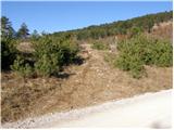 2
2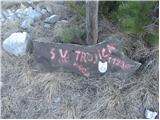 3
3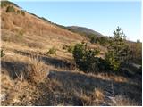 4
4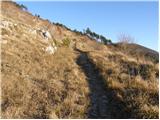 5
5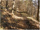 6
6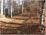 7
7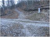 8
8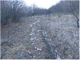 9
9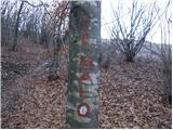 10
10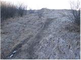 11
11 12
12
Discussion about the trip Vlačno - Sveta Trojica
|
| Planinček21. 02. 2008 |
If you want to go into nature, but at the beginning of the hiking season you don't have enough fitness yet, I recommend Sveta Trojica. Easy path with nice views from the top from Nanos, Vremščica to Javorniki.
|
|
|
|
| Biser gora21. 01. 2009 |
Is this path trodden in winter?
|
|
|
|
| Tadej23. 01. 2009 |
Currently the path is dry, but probably snow-covered tomorrow.
|
|
|
|
| Rok31. 01. 2009 |
I tried printing and it works normally for me.
Where does the error occur?
|
|
|
|
| ZOJA26. 02. 2011 |
Nice greeting! Is there any snow on Trojica?
|
|
|
|
| matdra10. 06. 2012 |
At Sv. Trojica the stamp needs replacing as the current one is completely unusable.
|
|
|
|
| klavdipo23. 01. 2013 |
Please provide information: has the summit stamp been repaired?
|
|
|
|
| SunnyDay31. 10. 2013 |
The stamp is new, but you need to bring your own ink pad or ink. The signpost at the parking lot has also been repaired and all direction signs are in excellent condition. The church is completely renovated. It often blows strongly on the summit!
|
|
|
|
| sijoze27. 12. 2015 |
The stamp is gone, someone unscrewed it and took it
|
|
|
|
| Ljubljana19. 12. 2016 |
"... and continue to the intersection near the military area, where we continue right. Then we drive only about 100m further to the parking lot on the road, which is located just a few meters before a smaller intersection (to the right a worse forest road branches off." Complete confusion of instructions. Correct is: at the end of the village Trnje, the road splits into left - Kurirčkova pot and right - Sveta Trojica. We continue right and follow the macadam road, which climbs for a while. When we reach the junction of the macadam road, we park and on the left side we spot the signpost Sveta Trojica. From the fork at the end of the village Trnje to the parking lot it's by no means only 100 m but certainly at least 1 km. P.s. there's a new stamp at the top. Lp.
|
|
|
|
| jure197726. 12. 2016 |
Measured exactly today... From the end of Trnje village it's 2.9 km to the parking lot. Follow the signs for Sv. Trojica, at the junction (about 2.5 km from the end of the village), where it points left to Sv. Trojica, continue straight ahead (marked).
|
|
|
|
| Lisica16. 04. 2020 |
Today I was heading along this path but the army turned me back. Apparently they were having exercises up there. I didn't know if one can continue to the right. More luck next time. 
|
|
|
|
| Lisica25. 04. 2020 |
Today succeeded on this path. This time I didn't turn to Poček  and there was no army either. Super nice path about an hour up. A little traffic just enough so it's not too boring. and there was no army either. Super nice path about an hour up. A little traffic just enough so it's not too boring.
|
|
|
|
| bizgo9315. 02. 2021 |
The first kilometer of the path and especially the last 300 meters (if you don't go along the macadam road by the way of the cross but cross the slope) are steeper. The summit is usually quite windy but the view is therefore very nice (Javorniki, Postojna & Pivka basin, Snežnik mountain range, Čičarija etc.). The Church of the Holy Trinity is currently under renovation, so don't be surprised by any machinery, cement pallets and the like.
|
|
|
|
| KatkaPo2. 02. 2023 20:26:29 |
Has anyone been to Sv. Trojica? What are the conditions? Trail ok?
|
|
|
To post a comment you must log in:
If you do not yet have a username, you must first
register.