Vinišnik - Kremžarjev vrh (below the peak)
Starting point: Vinišnik (550 m)
Route name: below the peak
Walking time: 1 h 30 min
Difficulty: easy marked way
Elevation gain: 614 m
Elevation difference along the route: 615 m
Map: Pohorje 1:50.000
Recommended equipment (summer):
Recommended equipment (winter):
Views: 2.900
 | 1 person like this post |
Access to starting point:
A) From Velenje or Dravograd we drive to Slovenj Gradec, and here in the roundabout, which is situated on the main road Dravograd - Velenje, we take the exit towards Kope and Legen. The road then soon brings us to the next intersection, where we turn right (in the direction of the ski center Kope). In this direction we drive approximately 2.2 km to the next intersection, where we turn left (in this direction there are signposts for a few farms and a marked path towards Kremžarica). At the next intersection after 500 m we again turn left (in the direction of the picnic area Vinišnik). We continue with a short uphill drive, we reach a macadam road and on the left side we notice a parking lot.
B) From the regional road Mislinja - Slovenj Gradec we drive to the settlement Šmartno pri Slovenj Gradcu and later Legen, we drive past the church of St. Jurij and then we turn right in the direction of the ski center Kope. In this direction we continue approximately 300 m to the next intersection, where we turn left (in this direction there are signposts for a few farms and a marked path towards Kremžarca). At the next intersection after 500 m we again turn left in the direction of the picnic area Vinišnik. We continue with a short uphill drive, we reach a macadam road and on the left side we notice a parking lot, which is intended for hikers to Kremžarjev vrh.
Route description:
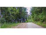
From the parking lot, we continue on the road which leads to the picnic area Vinišnik. After a few minutes of walking, the trail marking directs us to the right on a worse, steeper road, past smaller farms. The road slowly changes into a forest gully or cart track. In front of us is 40 minutes of uphill walking on a marked path which runs along a cart track and forest paths. After the end of the cart track, we cross an intersection of macadam roads where the "main road" leads to sv. Barbara, and in the other direction to the valley or our destination. Our marked path continues on the other side of the road and from there we can in this part observe Slovenj Gradec and the peaks of the nearby mountains (Uršlja gora, Peca). After 15 minutes of walking on the cart track and by pastures and past the farm Lampret we cross the road and come to a junction. We have the option to decide for a shorter path under the summit or the path over the summit.
The shorter path takes us 30 minutes of walking and leads us on a fairly flat beaten path past the water intake. Towards the end it turns into a slight incline. The incline quickly eases and the path brings us to an indistinct ridge on which footpaths from Vuzenica, Grmovškov dom and the path Vinišnik - Kremžarjev vrh (over the summit) meet. On the ridge there is an interesting half-open glass chapel with a wish bell and a junction where we ascend sharply to the right to Kremžarjev vrh. The ascent lasts the remaining 7 minutes, but it is worth it, as a beautiful view opens towards Košenjak.
We can also descend to the Koča na Kremžarjevem vrhu. The descent takes 3 minutes.

Photos:
 1
1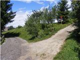 2
2 3
3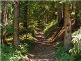 4
4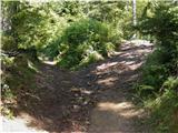 5
5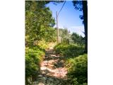 6
6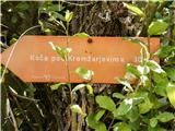 7
7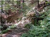 8
8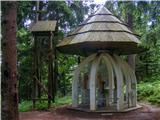 9
9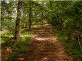 10
10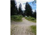 11
11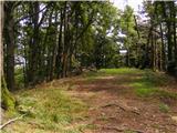 12
12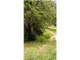 13
13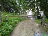 14
14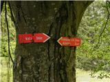 15
15
Discussion about the trip Vinišnik - Kremžarjev vrh (below the peak)
|
| timi_9514. 07. 2016 |
Hello!
Since the description cannot be edited, I'm posting a slightly corrected Access to the starting point:
a) From Velenje or Dravograd, we drive to Slovenj Gradec, where at the roundabout on the main road Dravograd - Velenje we take the exit for Kope and Legen. The road soon brings us to the next intersection, where we turn right (towards the ski center Kope). In this direction, we drive approximately 2.2 km to the next intersection, where we turn LEFT (in this direction there are signs for some farms and marked path for Kremžarica). In the next intersection after 500 m, we turn LEFT again (towards the Vinisnik picnic area). We continue with a short drive uphill, meet the macadam road and notice the parking lot on the left side.
b) From the regional road Mislinja - Slovenj Gradec, we drive to the settlement Smartno pri Slovenj Gradcu and later Legen, we drive past the church of St. Jurij and then turn right towards the ski center Kope. In this direction, we continue approximately 300 m to the next intersection, where we turn left (in this direction there are signs for some farms and marked path for Kremžarica). In the next intersection after 500 m, we turn LEFT towards the Vinisnik picnic area. We continue with a short drive uphill, meet the macadam road and notice the parking lot on the left side, which is intended for hikers to Kremžarjev Vrh.
Path to the summit: When we reach the glass chapel, we turn sharply right, a few minutes walk uphill. We follow the red triangles marking the path to the summit.
The path is otherwise wonderful, mostly through the forest - shade and no difficult ascents.
Thank you for understanding
|
|
|
To post a comment you must log in:
If you do not yet have a username, you must first
register.