Starting point: V Koncu (900 m)
| Latitude/Longitude: | 46,342°N 14,5682°E |
| |
Walking time: 4 h
Difficulty: difficult unmarked way, easy pathless terrain
Elevation gain: 1389 m
Elevation difference along the route: 1389 m
Map: Kamniške in Savinjske Alpe 1:50.000
Recommended equipment (summer):
Recommended equipment (winter): ice axe, crampons
Views: 11.238
 | 1 person like this post |
Access to starting point:
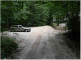
We drive to Kamnik and follow the road ahead towards the valley of Kamniška Bistrica. From the hut in Kamniška Bistrica we continue driving on the forest road which takes us higher to a junction, where we continue straight (right Jermanca, starting point for Kamniško sedlo). The road then past Žagana peč brings us to the parking lot at the lower station of the cargo cableway to Kokrsko sedlo.
Driving from the mountain hut in Kamniška Bistrica to the parking lot V Koncu is now forbidden (traffic sign), this extends the path by less than an hour.
Route description:
From the parking lot at the cargo cableway we continue on an increasingly rough road which after 10 minutes of walking changes into a cart track. The cart track splits into two parts, and we head for the right one (left cart track vanishes, or leads towards Gamsov skret), which by the smaller boulder covered with moss (big rock) turns a little more to the right. Right at this spot we leave the cart track and continue straight on at first a poorly visible footpath which later steeply ascends in switchbacks. Steep and mainly when wet dangerous for slipping path leads us over steep slopes, which are on some spots secured with a steel cable. Steep path, which also crosses a few gullies, brings us higher to less steep slopes. After a good hour of walking, the path brings us out of the forest, where it starts to ascend steeply again. The path first leads over grassy slopes surrounded by sparse forest, then with the help of some fixed protections brings us a level higher. The path ahead passes onto gravelly slopes, which make the ascent somewhat more difficult, then the path turns left onto steep grassy slopes, which rise above extensive scree fields. At the top of this grassy part we head slightly right and the path passes from grass to the high-mountain world of the basins under Skuta. Further along the path surrounded by cairns in a few minutes we come to the pleasant bivouac under Skuta.
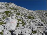
From the bivouac we continue on a poorly visible and still unmarked path along an indistinct ridgelet, which after 15 minutes of walking from the bivouac brings us to the marked path Kamniško sedlo - Kokrsko sedlo. Here we continue right and already after a few minutes we come to a junction, where we continue sharply left in the direction of Skuta and Rinka. Only a little further we come to the next junctions, where we continue right upwards in the direction of Rinka (straight Skuta). The path ahead steeply ascends for a short time, then brings us to an indistinct ridge along and beside which we then ascend. When the marked path turns left and starts to descend, we leave it and continue right on easier pathless terrain, on which in one minute of further walking we reach the summit of Mala Rinka.
In fog the orientation above the bivouac under Skuta is very difficult.
V Koncu - bivouac under Skuta 3:00, bivouac under Skuta - Mala Rinka 1:00.

Photos:
 1
1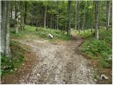 2
2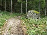 3
3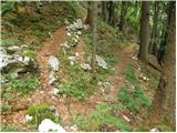 4
4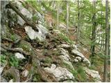 5
5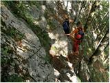 6
6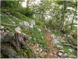 7
7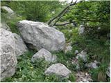 8
8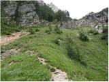 9
9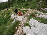 10
10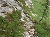 11
11 12
12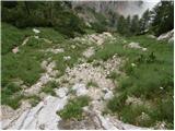 13
13 14
14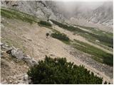 15
15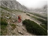 16
16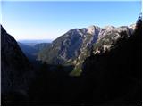 17
17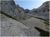 18
18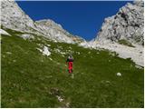 19
19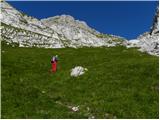 20
20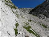 21
21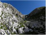 22
22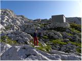 23
23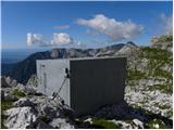 24
24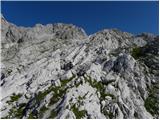 25
25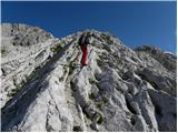 26
26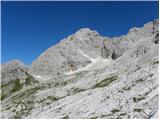 27
27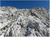 28
28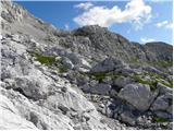 29
29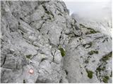 30
30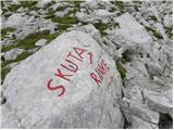 31
3132
 33
33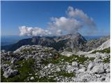 34
34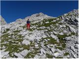 35
35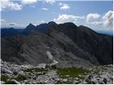 36
36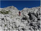 37
37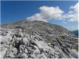 38
38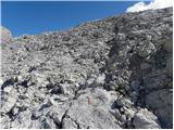 39
39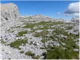 40
40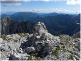 41
41
Discussion about the trip V Koncu - Mala Rinka
|
| ožep22. 08. 2025 15:56:14 |
Very poorly marked trail. The marks that there are have faded.
😒
|
|
|
|
| Zapp22. 08. 2025 16:09:07 |
It says demanding UNMARKED path, possibly OFF-TRAIL. Otherwise, the trail is nicely traceable through the scree, onwards from the bivouac just straight up.
|
|
|
|
| Stane722. 08. 2025 17:36:06 |
Unmarked paths and off-trail routes are mostly not marked.
|
|
|
|
| ožep24. 08. 2025 09:23:39 |
Zapp and Stane7
I'm talking about the marked trail if you can read. From the junction towards Rinke it's marked, but poorly, few marks and faded. Through Žmavcarje I know it's unmarked and there was no problem following.
|
|
|
|
| garmont24. 08. 2025 10:48:54 |
@ožep, you're not commenting on the trail described above.
|
|
|
|
| ožep24. 08. 2025 11:29:36 |
Then, please explain it yourself.
|
|
|
|
| garmont24. 08. 2025 11:47:18 |
Okay, I will.
You commented on a trail classified as “difficult unmarked path and possibly pathless”.
Your comment refers to the marked path to Mala Rinka, which is not the topic here and is not even described.
It's not that hard to understand.
|
|
|
|
| Enka24. 08. 2025 12:42:39 |
That part that ožep writes about in the other comment, i.e. the section of the path from the Skuta - Rinke - Turska gora junction towards the Rinke, is of course a marked path - it's even part of SPP as it leads to Koroška Rinka (only the last few meters from the path to the top of Mala Rinka are unmarked). And at least 3-4 years ago when I last hiked there, the markers were actually faded and very poorly visible. If you know where you're going, no problem, but if it's your first time there, you might really struggle a bit more with orientation.
|
|
|
|
| garmont24. 08. 2025 12:49:45 |
@Enka, you're absolutely right. In between it's the marked section to MR.
@ožep, I apologize. 
|
|
|
To post a comment you must log in:
If you do not yet have a username, you must first
register.