V Koncu - Grintovec (via Dolge stene)
Starting point: V Koncu (900 m)
| Latitude/Longitude: | 46,342°N 14,5682°E |
| |
Route name: via Dolge stene
Walking time: 5 h
Difficulty: very difficult pathless terrain
Elevation gain: 1658 m
Elevation difference along the route: 1658 m
Map: Kamniške in savinjske Alpe 1:50.000
Recommended equipment (summer): helmet
Recommended equipment (winter): helmet, ice axe, crampons
Views: 17.869
 | 5 people like this post |
Access to starting point:
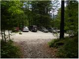
We drive to Kamnik and follow the road ahead towards the valley of Kamniška Bistrica. From Dom v Kamniški Bistrici we continue driving on the forest road, which higher up brings us to a crossroad, where we continue straight (right Jermanca, starting point for Kamniško sedlo). The road then past Žagana peč brings us to the parking lot at the lower station of the cargo cableway to Kokrsko sedlo.
Driving from Koča v Kamniški Bistrici to the parking lot V Koncu is now forbidden (traffic sign), this extends our path by less than an hour.
Route description:
From the parking lot at the cargo cableway we head onto the footpath in the direction of Kokrsko sedlo and Grintovec. The path, which runs through the forest, initially ascends only gently, but this part of the path is short. Already after a few minutes of walking, the path starts to ascend steeply and a little higher there are fixed safety gear to help us, which come in handy on wet and slippery ground (when dry undemanding). The well-visible and still steep path higher starts to turn somewhat to the right. The steepness then eases for a short time and the path brings us out of the forest onto avalanche slopes below Kokrsko sedlo. Here the path stands upright again and ascends at the foot of the walls of Kalška gora and Mali vrh with ever more beautiful views (these are the most beautiful on the peaks above the valley of Kamniška Bistrica). Easy to follow but due to a lot of stones (slightly overgrown scree) on the path, strenuous path brings us after a good 2 hours of walking to Kokrsko sedlo, where Cojzova koča stands.
From the saddle we continue right in the direction of Grintovec, Kočna and Skuta. The path immediately above the saddle ascends steeply and a little higher brings us to a junction, where the path to the bivouac under Grintovec and Skuta branches off to the right (straight to Grintovec via Streha and Kočna). We head onto this initially somewhat poorly visible track, which in a moderate ascent brings us to the scenic passage over Mala vratca. Right before the passage over Mala vratca we turn left, where occasionally we spot a poorly visible track that leads along the ridge of Dolge stene. When we reach the first ridge, a view opens towards Grintovec. From here onwards we follow the relatively level grassy path along the ridge, orientation in nice weather is not difficult. On the right side the terrain drops steeply to Velike Pode, we also spot the bivouac of Pavle Kemperle below Grintovec. After an hour and a half of walking we reach the most demanding part of the path. From here the path steeply rises into the southeast wall of Grintovec, which then ends in the cirque Zgornje jame. The initial entry is practically invisible, we must only take care to stay somewhat to the left, as the right part is more demanding. The terrain is very crumbly, so caution is necessary. Here we cross a smaller jump and turn somewhat left towards the ridge. After 30 minutes we reach the ridge, and the path becomes easier. Here a view opens towards Mlinarsko sedlo and Skuta. We cross left (cairns) and follow the track to the usual path via Streha some 10 m below the summit of Grintovec. A short ascent follows on the marked path and soon we reach the summit.

Photos:
 1
1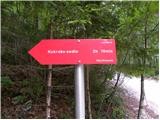 2
2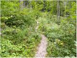 3
3 4
4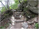 5
5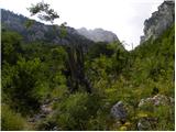 6
6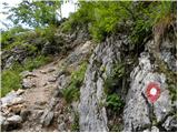 7
7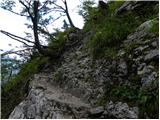 8
8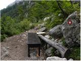 9
9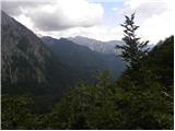 10
10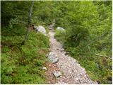 11
11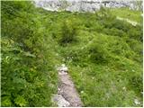 12
12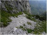 13
13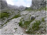 14
14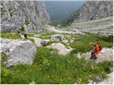 15
15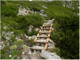 16
16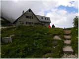 17
17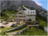 18
18 19
19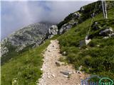 20
20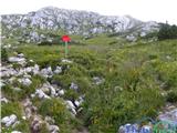 21
21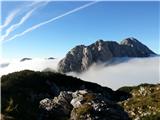 22
22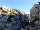 23
23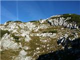 24
24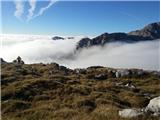 25
25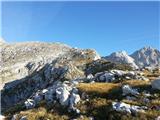 26
26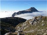 27
27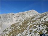 28
28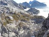 29
29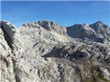 30
30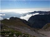 31
31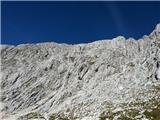 32
32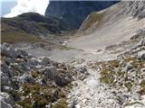 33
33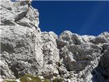 34
34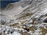 35
35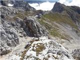 36
36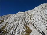 37
37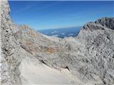 38
38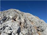 39
39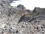 40
40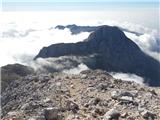 41
41 42
42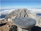 43
43
Discussion about the trip V Koncu - Grintovec (via Dolge stene)
|
| CarpeDiem24730. 10. 2014 |
This path is much more interesting than the classic one (via Streha). Anyone with at least some high mountain experience can use this path for ascent and then descent via Streha. You won't regret it! 
|
|
|
|
| borutpovse30. 10. 2014 |
How long should the path from this direction take? LP
|
|
|
|
| franca31. 10. 2014 |
Approximately as much as via Streha. If you miss the optimal direction, a bit longer
|
|
|
|
| Branee31. 10. 2014 |
I don't know who's crazier here.. The one asking or the one answering? Everything is written on this very page, use your gray cells a bit
|
|
|
|
| CarpeDiem24731. 10. 2014 |
In some old mountaineering guide (booklet) I still remember reading years ago about both mentioned paths, which started at Cojzova koča and both were rated 2h to the top of the first KSA. 
|
|
|
|
| Tonetone18. 06. 2017 |
The published description is completely wrong in the upper half and describes the winter variant called Route through Dolge stene. The actual summer SPD path runs elsewhere. From the ridge of Dolge stene it branches left before the ridge starts rising steeply. We cross horizontally left under the lowest part of the wall, where remnants of the path in the scree are visible, and on the rocks there are also still faded red marks visible. The path leads from here about 100 m almost horizontally to the left, then begins to rise diagonally. The last 100 m climb almost straight up. To the edge where there is a larger cairn and we reach the marked path, we arrive about 150 altitude meters below the summit.
|
|
|
|
| alesfon21. 07. 2020 |
Today hiked this trail. From Vratc to the ridge, a visible path and occasional red color marks... actually you can go along the ridge all the time, with nice views. For the last part I followed the red line (from the photo of the previous comment). At the beginning I searched a bit for the entry then just followed the cairns (I fixed some). There's some climbing all the time but not too difficult and not too crumbly. Nice trail, I'll repeat it.
|
|
|
|
| hribba3. 10. 2021 21:27:01 |
Yesterday I went for the third time on this magnificent trail. Descent via Kalška gora on the hunting trail to Žagana peč.
Description and photos - Grintovec čez Dolge stene
|
|
|
|
| CarpeDiem2476. 11. 2022 22:04:48 |
This path is definitely a good alternative to Streha, at the same time more solitary and worth visiting.
|
|
|
|
| Tonetone7. 09. 2025 13:01:43 |
I don't know why the two pictures I attached are not visible. The links are broken. I can resend the pictures, as the description is not complete without them.
|
|
|
|
| turbo7. 09. 2025 13:18:29 |
You have to post the tour report in the Forum - Conditions section, there you can add photos, unfortunately not here.
|
|
|
|
| Krrokarr6. 11. 2025 17:07:56 |
Why hasn't the description here been corrected yet?
It's right, as Tonetone wrote.
Is there a way to notify the moderators?
|
|
|
|
| Tadej7. 11. 2025 10:46:18 |
Thanks for the warning.
If I understand correctly, based on what's written, I just change the path name to Route along the southeast ridge?
|
|
|
To post a comment you must log in:
If you do not yet have a username, you must first
register.