V Koncu - Skuta (via Gamsov skret)
Starting point: V Koncu (900 m)
Route name: via Gamsov skret
Walking time: 5 h 15 min
Difficulty: very difficult unmarked way, difficult marked way
Elevation gain: 1632 m
Elevation difference along the route: 1750 m
Map: Kamniške in Savinjske Alpe 1:50.000
Recommended equipment (summer): helmet
Recommended equipment (winter): helmet, ice axe, crampons
Views: 39.699
 | 4 people like this post |
Access to starting point:
We drive to Kamnik and follow the road ahead towards the valley of Kamniška Bistrica. From the hut in Kamniška Bistrica we continue driving on the forest road, which brings us higher up to a crossroad, where we continue straight (right Jermanca, starting point for Kamniško sedlo). The road then past Žagana peč brings us to the parking lot at the lower station of the cargo cableway to Kokrsko sedlo.
Route description:
From the parking lot at the bottom station of the cableway, we continue on the road to the «upper parking lot». Here, by the parking lot on the left side of the road, we will notice two cart tracks. The left cart track, which is marked with signs on a tree, leads towards Kokrsko sedlo. We, however, head to the right cart track (this cart track is also on the left side of the road).
At first, we walk for some time on the mentioned cart track, from which some side cart tracks also branch off, then the cart track turns into a footpath. Further on, we ascend for quite some time on a narrow footpath through the forest. The path here continuously runs on the left side of the valley and thus avoids the steep rocky drop in the lower part of the valley.
When we come out of the forest, the path crosses somewhat steeper slopes to the right and brings us to grassy slopes. This is followed by an ascent over grassy terrain, which brings us below the walls of Kogl.
Here, the better-trodden footpath turns left towards the wall, but we continue slightly right on a narrow footpath. The path in this section is quite poorly visible and runs on the left side of the torrent up the valley. For orientation, the clearly visible waterfall of the mentioned torrent (usually without water) can serve. The footpath already somewhat before the waterfall turns left and enters the wall.
Here the path becomes very demanding and first we must climb a few meters up the almost vertical slope. This is followed by an ascent on a narrow secured ledge, which crosses the slope to the right and brings us to steep grassy slopes. Although the ledge is secured, the ascent is quite demanding. It must also be taken into account that the fixed protections are usually in somewhat worse condition than we are used to on marked paths. Further on, we ascend for some time on quite steep grassy slopes, then the slope gradually becomes less steep and the path brings us to an unexpected bench from which there is also a very nice view in all directions.
Further on, we ascend the grassy slope up to the marked path Kokrsko sedlo - Kamniško sedlo.
Here we turn left and follow the marked path, which with gentle descents and ascents soon brings us to a junction, where we continue right in the direction of Grintovec and Skuta (left bivouac 1 minute) on a relatively even path, which soon brings us to the next junction. We continue right in the direction of Skuta (straight Mlinarsko sedlo) on the path that takes us across the karst terrain of Veliki podi to the foot of a moderately steep wall. Here the path becomes vertical and with the help of natural holds we overcome a short wall between Dolgi hrbet and Štruca (in wet great risk of slipping). At the top of the ascent, the path from Dolgi hrbet joins us from the left. We continue right, where then in a gentle descent with the help of a few pegs we bypass the summit of Štruca on the left side. The path then brings us to an indistinct saddle between Štruca and Skuta, from which we ascend to the summit in 15 minutes on the undemanding summit slope of Skuta.
V Koncu - Bivouac 3:15, Bivouac - Skuta 2:00.

Photos:
 1
1 2
2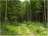 3
3 4
4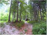 5
5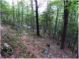 6
6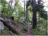 7
7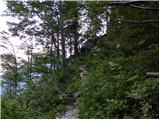 8
8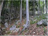 9
9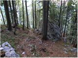 10
10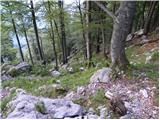 11
11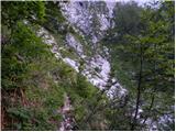 12
12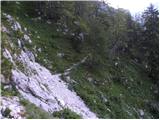 13
13 14
14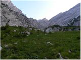 15
15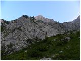 16
16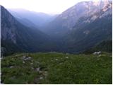 17
17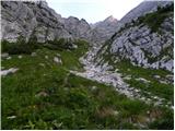 18
18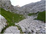 19
19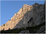 20
20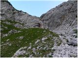 21
21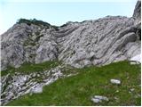 22
22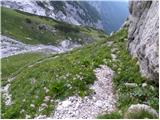 23
23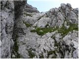 24
24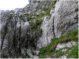 25
25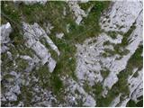 26
26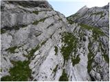 27
27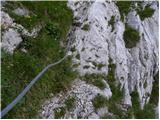 28
28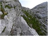 29
29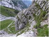 30
30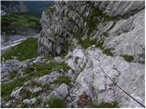 31
31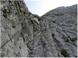 32
32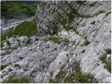 33
33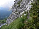 34
34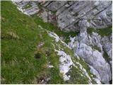 35
35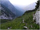 36
36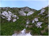 37
37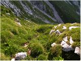 38
38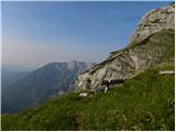 39
39 40
40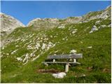 41
41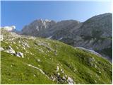 42
42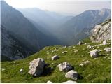 43
43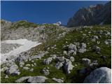 44
44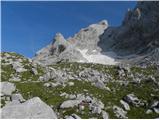 45
45 46
46 47
47 48
48 49
49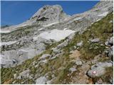 50
50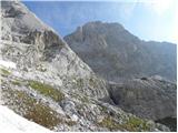 51
51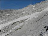 52
52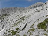 53
53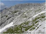 54
54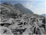 55
55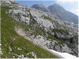 56
56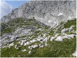 57
57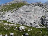 58
58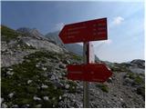 59
59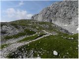 60
60 61
61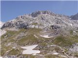 62
62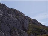 63
63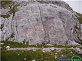 64
64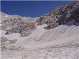 65
65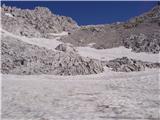 66
66 67
67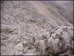 68
68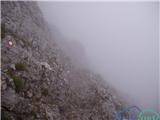 69
69 70
70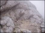 71
71 72
72
Discussion about the trip V Koncu - Skuta (via Gamsov skret)
|
| enjanez31. 07. 2008 |
A few days ago my colleague and I missed the trail entrance. Below the scree slope (picture 3) we followed tracks upwards at the hunting stand. There were no tracks leading towards the left part of the valley, due to dense vegetation and fallen trees, nowhere visible. I remember the trail is well-trodden, so the trail start must be elsewhere than in this description.
|
|
|
|
| kopron31. 07. 2008 |
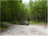
Picture 1 is the start of the path towards žmavčarjem. If you look at Picture 1, immediately to the left there's another cart track, that's the start of the path to Gamsov skret, after a few hundred meters it narrows and ahead it's a trail that continues in the gorges. Also if you look at picture 3 you can reach the trail much higher where it crosses that gully but you already have to climb a bit.
|
|
|
|
| kopron31. 07. 2008 |
Perhaps I wasn't precise enough before, in pic.1 left of the blue car is that previously described cart track which then continues as a trail into Gamsov skret.
|
|
|
|
| enjanez31. 07. 2008 |
Thank you very much. The trees felled by last year's snow confused us. But we got to see places that only hunters rarely visit. It was nice anyway.
|
|
|
|
| janez331. 07. 2008 |
The trip description (and GPS track on these pages) is the most confusing, as it first leads to Žmavčarje and then forces searching for connecting transverse paths in Koncu. Kopron is right. From the last parking lot along the left cart track northwards. When it branches, take the right fork and it continues as the path over Gamsov skret.
Up on Podih, if the wish is only to visit Skuta, there's no need to go to the bivouac. We follow the markings for a short time past the spot shown in pic.16, then leave them and turn right into pathless terrain. That we're on the right path is usually confirmed by cairns. Štruco is on our right, ahead Dolgi hrbet. We go straight up, in the last part above the hollow turn left and soon reach the marked path below D. hrbet.
|
|
|
|
| Pastirica1. 08. 2008 |
Kopron, if it's no secret, I'm interested in the upper part of that "...but you already have to climb a bit." Especially the crossing into Trato. Is there anything harder than in the lower half?
|
|
|
|
| kopron1. 08. 2008 |
The crossing to the upper part requires a bit of climbing, and there's also a fixed rope for assistance. To reach the rope, you have to go to the end of the lower part of the meadow right of the boulder (to the rock barrier). You spot the rope up left (see picture 8). Then along the ledge, where there's also a rope.
|
|
|
|
| Pastirica1. 08. 2008 |
Now we're not talking about the same thing. I have picture 3 in mind and the crossing into the Meadow BELOW the Boulder.
|
|
|
|
| kopron1. 08. 2008 |
To get from this gully to the meadow, you in any case have to reach the path that crosses this gully and leads further towards the boulder and Gamsov Skret. There is also the junction for Mali Hudi Graben. It's been many years since I went up the gully. I also went over Gamsov Skret last five years ago.
|
|
|
|
| Pastirica1. 08. 2008 |
Now I understand. So there is no climbing to the spot on pic.8, only at the bottom you have to start properly. THANKS!
|
|
|
|
| kopron2. 08. 2008 |
There is no climbing except there at pictures 8 and 9 as it holds together. Even when going up you hardly need it. You need it when descending, and orientation is also quite demanding when descending over Gamsov Skret. Much easier descent over Žmavčarje.
|
|
|
|
| NEIC00826. 07. 2009 |
''A few days ago, my colleague and I missed the start of the trail. Below the scree (picture 3), at the hunting stand, we followed tracks upwards. There were no tracks leading to the left part of the valley, due to dense vegetation and fallen trees, nowhere to be seen. I remember the trail is well-trodden, so the start of the trail must be elsewhere than described here.''
THE SAME HAPPENED TO ME TODAY... BECAUSE OF THIS DOUBLE CLIMBING, THE FIRST ONE NOT EVEN MENTIONED (ENTRANCE TO THE WALL AT THE END OF THE SCREE) AND THEN THE ONE DESCRIBED ABOVE. THE TRAIL IS DEFINITELY NOT SUITABLE FOR DESCENT, AND ALSO ORIENTATIONALLY DEMANDING.. MY ADVICE: IF YOU DON'T KNOW THE TRAIL, CHOOSE ONLY MARKED ONES.. 
|
|
|
|
| techouse6. 10. 2014 |
Nice hike. The path was TOP this weekend. 
|
|
|
|
| grega_z_brega15. 11. 2015 |
On the path in the forest there are fallen trees in one section, but it's better to climb over them than to choose the unpleasant detour to the right, which then brings us back to the path via a gully.
Everything else is fine.
The fixed cables are new.
|
|
|
|
| trdi29. 08. 2017 |
Yeah the description here isn't the best, or the pictures need updating. Now I read NEIC008's report. That scree thing happened to me this year, the path through that scree is quite trodden, so probably many hikers get confused, but I didn't dare past that wall because I didn't know where it leads, but on geopedija I saw that behind the wall it's meadow again and probably no panic...
|
|
|
To post a comment you must log in:
If you do not yet have a username, you must first
register.