Učja - Monte Guarda/Skutnik
Starting point: Učja (655 m)
| Latitude/Longitude: | 46,3069°N 13,4014°E |
| |
Walking time: 3 h 45 min
Difficulty: easy marked way
Elevation gain: 1066 m
Elevation difference along the route: 1066 m
Map: Julijske Alpe - zahodni del 1:50.000
Recommended equipment (summer):
Recommended equipment (winter): ice axe, crampons
Views: 31.544
 | 2 people like this post |
Access to starting point:
From the Tolmin direction we drive through Kobarid towards Bovec. In the village Žaga we turn left towards the border crossing Učja. Approximately 300 meters from the Italian hut of the former border crossing we turn right into the village. In the middle of the village we turn sharply right on the road which brings us to the little church. We can park the car there or on one of the lay-bys by the road.
Route description:
The Mt. Guarda sign (Italian path marking is 733) we notice around 150 meters before the little church on the left. There the footpath starts, which leads us past several older houses and in a few minutes brings us into a young forest. We continue on the well-marked path through mature forest, where a wooden cross stands, and a little later the path also crosses a steel rope (remnant of the cableway for hauling wood).
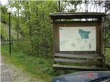
After a good hour and a half of walking through the forest we come to the northern side of Kal (1297 m). The grassy slope of our ridge presents itself to us, below it the idyllic mountain pasture Kal. The path leads slightly downwards and then ascends again, with the difference that now trees do not surround us. The good mule track rises quite gently along the steep ridge, until we come to the top of the ridge. There a board with signs awaits us. From here to the top of Skutnik it is only another 25 minutes of walking on the varied ridge. On the summit there is a logbook and a metal cross.

Photos:
 1
1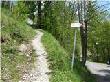 2
2 3
3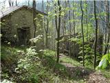 4
4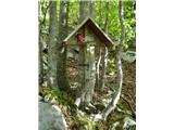 5
5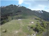 6
6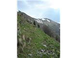 7
7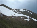 8
8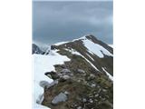 9
9 10
10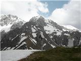 11
11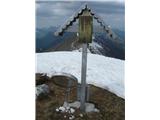 12
12 13
13
Discussion about the trip Učja - Monte Guarda/Skutnik
|
| anka 30. 06. 2009 |
Beautiful trail and everything that comes with it, just the start of the path is found 150 m further from the chapel.
|
|
|
|
| Lj30. 06. 2009 |
Anka, were you perhaps on Skutnik now when the Italians have tightened border control? We had it planned this week, but the police in Kobarid advised against it, saying we might have problems with the Italian police?!
|
|
|
|
| triglavski1. 07. 2009 |
Yesterday I returned from Italy via Rezija, at the Učja crossing there were members of the Guardia di finanze, but not those from Skutnik, I had no problems because I had valid documents, just like you won't have if you go to Guarda, because Guardia members don't go up there, well at least I haven't met them up there yet, but I have met them elsewhere in the mountains, because they also do rescues.
|
|
|
|
| Lj1. 07. 2009 |
Triglavski, thanks for the encouraging information. 
|
|
|
|
| Lj18. 07. 2010 |
Well, only this year the weather was merciful to my wife and me and on 15.7. we visited Skutnik from planina Kot (Casera Coot). The drive from Kobarid via Učja to Resia - Stolvizza - Korito (Coritis) to the parking under planina Kot is quite long and varied, a real test for the driver and the last 2 hairpins to the parking under the planina . We ascended Skutnik via path 741, which is steeper and shorter, and planned to descend via the longer path 731. The ascent on path 741 is really pleasant, but the part of path 731 that crosses the slope of Mala baba has practically disappeared. Since there was no warning neither at the planina nor before starting the crossing under Mala baba that the path is impassable, we tried to continue for a while hoping that the path is destroyed only on a shorter distance. Soon we realized that the risk of slipping is too great and we had trouble even getting back. The path drawn on the map is in practice due to erosion a very dangerous trap for someone without information about the change on the ground. A warning sign is necessary, I hope nothing happens to anyone before. Given the long and demanding drive to planina Kot, the ascent from our side as described above is more recommendable. The advantage of ascent from the Italian side is the shady location and less elevation gain. . We ascended Skutnik via path 741, which is steeper and shorter, and planned to descend via the longer path 731. The ascent on path 741 is really pleasant, but the part of path 731 that crosses the slope of Mala baba has practically disappeared. Since there was no warning neither at the planina nor before starting the crossing under Mala baba that the path is impassable, we tried to continue for a while hoping that the path is destroyed only on a shorter distance. Soon we realized that the risk of slipping is too great and we had trouble even getting back. The path drawn on the map is in practice due to erosion a very dangerous trap for someone without information about the change on the ground. A warning sign is necessary, I hope nothing happens to anyone before. Given the long and demanding drive to planina Kot, the ascent from our side as described above is more recommendable. The advantage of ascent from the Italian side is the shady location and less elevation gain.
|
|
|
|
| ljubitelj gora15. 09. 2014 |
On Sunday I headed to Skutnik via this described path, which is very nicely arranged. From Skutnik summit I continued to Baba, first with considerable descent then a long ascent up a wide gully to the saddle top, then to Velika Baba summit. Web album with descriptions:https://plus.google.com/photos/114400986607884783562/albums/6059255586276704433
|
|
|
|
| cenc5. 11. 2015 |
Sometimes it's nice for a change to visit grassy peaks right across the border.
The ascent to Rezjanski Skutnik is pure hiking poetry. For Mala Baba you already have to "bite" harder into the steepness, for Velika unfortunately we ran out of
time this time.
Whichever direction you look, ridges and peaks everywhere.....
|
|
|
|
| adry15. 12. 2015 |
On sunny Sunday 13.12. we used it for the ascent to Skutnik and Planja. The hike is very suitable for this time without snow, the path is all along through the forest and later on a warm sunny slope without wind. Peaks wonderful, views like on a plate without clouds towards Kanin and V. Baba, below on Planina Kot a real winter idyll. On the ridge snow only a sample, just enough to know it's December.
We met a large group of Italian hikers, so the summit was not lonely at all.
|
|
|
|
| M&P29. 10. 2017 |
In the village Žaga the Učja direction is crossed out due to road closure, nevertheless the starting point is reachable, as the closure is only at the last junction.
|
|
|
|
| UB7720. 06. 2018 |
Hello,
I'm wondering if the summit is suitable for a summer visit, given the path runs through grassy slopes? Maybe more suitable when there's no "šavje" yet? 
lp
|
|
|
|
| navdušena26. 06. 2018 |
Like this: from the little church walk further on foot along the asphalt road, about 200 m, when on the left side of the road we notice the sign for Skutnik (Monte Guarda).
And also: when we arrive from the forest to Travnik (behind Kal) there is a sign pointing left downhill to Kal, we continue straight ahead and soon tackle the slope.
When we reach the top of the ridge and the sign saying 25 minutes to Skutnik, we need almost 40 minutes to the summit!!
|
|
|
|
| haridautovic16. 12. 2018 |
We said, let's go check out this beautiful ridge that I always gaze at when going to Učjo or from Srpenica towards BC, and we went. From the village Uccea along path 733 to the saddle Ta-Na-Kalo/1234m, and onwards to the goal, in between we leave the marked path and climb steep grass to the ridge where super zoom views open up for us. Along the ridge to the top of Skutnik and back along the marked path to the starting point.
|
|
|
|
| darinka47. 11. 2019 |
The walking time in the village Učja on the sign reads 3 hours 45.
|
|
|
|
| Tadej9. 11. 2019 |
I corrected the walking time.
|
|
|
|
| Tadej9. 11. 2019 |
I corrected the walking time.
|
|
|
|
| haridautovic7. 04. 2020 |
4.4.2020 At the Republic and Municipal border,/To Skutnik from Žaga past the Globoški potok Waterfall along the mule track to the summit and past the former Globoka alpine pasture to the cattle shed and back to Žaga,
|
|
|
|
| darinka413. 05. 2020 |
I'm interested in the path from Planina Baban to Baba? Our last host told us it's possible to go. Has anyone been there already?
|
|
|
|
| rokeg13. 05. 2020 |
It's a marked pathless route, you really need to pay attention to the markers, which have already faded a lot. First it goes through a grassy valley, then to scree full of boulders and onwards to the saddle Med Baban, from there just left to the summit of Baba. In between you can somewhat notice it's a path.
|
|
|
|
| darinka419. 05. 2022 07:19:05 |
18. 5. It was really a day when we met no one. In the morning from Žaga past the Globoški slapovi. That part is steep. Descended via another former mulatjera, nicely laid out. Lots of ticks on the summit and path this year. And an adder was sunning itself in nettles just below the summit. This time Babe didn't hide and we had nice views. Most interesting are the old trees in the forest. On descent we also viewed the lower waterfall.
|
|
|
|
| atoamac5. 10. 2022 17:09:18 |
The road from Učja towards Resia is closed with a sign. In the area of the Karnica pass or the Njivice/Gnivice alpine pasture (about 4 km from the pass towards Učja), however, it is literally closed with a concrete barrier because they are renovating bridges (19!!!) and the roadbed, arranging fences, they have already installed nets against falling rocks, in short, the road will soon be suitable for some Giro. Some people were renovating weekend cottages or barns in the alpine pasture yesterday, but in the hills, as darinka4 says, I didn't meet anyone.
|
|
|
|
| rozka7. 10. 2022 14:13:09 |
atoamac, thanks for this info, more than welcome, I just hoped it might be possible 
but is there any info on when the road will open?
|
|
|
|
| atoamac7. 10. 2022 15:39:56 |
It looks like they're working and not much is left, as they're already mounting fences. But they still need to lay asphalt on the bridges. There's no notice on FVG Strade this year, maybe they started the works earlier. But it is possible to reach the Krnica saddle from Resia.
When will the road open? They probably have some Republic Day in Italy too :-)
|
|
|
|
| rozka12. 10. 2022 16:34:13 |
Thanks.
Yes, I know from Rezija, but this "passage" is very useful and shortens the drive quite a bit.
I hope they finish and open the road as soon as possible
|
|
|
|
| darinka430. 03. 2024 20:46:12 |
If anyone's interested in Skutnik from Žaga. The path is dry. No winter gear needed. Verified today.
|
|
|
|
| darinka414. 05. 2025 08:43:40 |
Yesterday on the 13th of May after a long time we set off from Učja to Skutnik. The path is dry. Since we were at the top before eleven o'clock we decided to go check towards bivouac Konstantini how much snow is left to Babe. Interestingly we met two hikers from Italy at the bivouac who knew Slovenian. One from Udine said he had attended a Slovenian language course.
|
|
|
|
| mirank15. 05. 2025 13:12:13 |
Udine folks from Vidma ;)
|
|
|
|
| turbo15. 05. 2025 13:28:45 |
|
|
|
|
| mirank15. 05. 2025 14:41:58 |
Now I really don't know anymore if the Beneški boys are from Beneška Slovenija or from the Veneto region?
|
|
|
|
| turbo15. 05. 2025 15:21:05 |
|
|
|
To post a comment you must log in:
If you do not yet have a username, you must first
register.