Trenta - Zasavska koča na Prehodavcih
Starting point: Trenta (620 m)
| Latitude/Longitude: | 46,3772°N 13,7495°E |
| |
Walking time: 4 h 15 min
Difficulty: easy marked way
Elevation gain: 1451 m
Elevation difference along the route: 1451 m
Map: TNP 1:50.000
Recommended equipment (summer):
Recommended equipment (winter): ice axe, crampons
Views: 87.640
 | 5 people like this post |
Access to starting point:
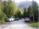
A) First, we drive to Kranjska Gora, and then we continue driving through the mountain pass Vršič towards Bovec. Soon after the 50th serpentine the road crosses the river Krajcarica, from where we drive for approximately 1 km to the spot where a gate-closed forest road branches off to the left. We park a few meters before the gate on an appropriate place by the road.
B) We drive to Bovec, and then we continue driving towards Trenta. When we arrive in Trenta, we will notice before the center of the settlement a forest road which from the main road branches off sharply to the right. At the mentioned crossroad, which is located a few 100 meters before the center of Trenta we turn sharply right and then we park on an appropriate place by the road.
Route description:
From the gate, we continue on the forest road, which ascends gently and brings us to a crossroad, by which there is a smaller "parking lot". From the crossroad, we continue on the lower right road following the signs Prehodavci, but we walk on it only a short time, as then the signs lead us left into the forest. The path ahead leads us past a house and behind it starts ascending again. Further on, we ascend along the stream Beladovec, on which we can notice some nice smaller waterfalls. During the ascent along the stream the path gradually becomes less steep, then it turns slightly to the left, where it flattens even more. There follows a few minutes of entirely easy walking, then the path, which runs along an old mule track, starts to ascend moderately in zigzags. For some time we still ascend through the forest, then, when we are already high above the stream, the forest also gradually starts to thin. There follows a few more minutes of walking and the path brings us to the hunting cottage in Trebiški dol.
The path ahead still continues on the mule track, which leads us below the ridge of Špičje on the right and Velika glava and Veliki Konj on the left. A moderately steep path, which continues through a panoramic valley, splits a little higher into two parts.
We continue on the right path (straight saddle Čez dol, Zadnjica and Zadnjiški Ozebnik, to the latter leads an unmarked footpath) in the direction of Prehodavci. Only a few 10 meters higher we arrive at the next junction, where the path from saddle Čez dol and Zadnjica joins us. Again we continue right and continue the path further on the wide mule track, which then crosses somewhat precipitous slopes. During the ascent over the precipitous slope we will notice on the left side a smaller "chapel" (statue of Mary with Jesus).
Further on, the slope along which the path runs becomes less steep and increasingly panoramic. Higher, the well-preserved mule track leads us over a somewhat less steep slope of Zelena griva, above which the slope becomes steeper again. There follows a few shorter steep sections, then the path and likewise the slope flatten. Somewhat above the indistinct break we arrive at a marked junction, where we continue left (right Lepo or Veliko špičje - path of Stanko Kosa, straight Koča pri Triglavskih jezerih) towards the nearby Zasavska koča na Prehodavcih. The path ahead leads us along a wide and panoramic ridge, which past the winter bivouac brings us to the Zasavska koča in a few minutes.

Along the route: Planina Lepoč (1090m), Planina Trebiščina (1412m), Čez Dol (1632m)
Photos:
 1
1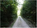 2
2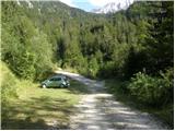 3
3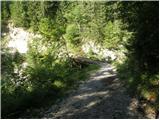 4
4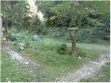 5
5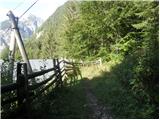 6
6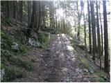 7
7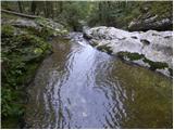 8
8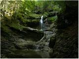 9
9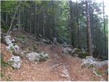 10
10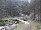 11
11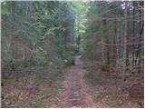 12
12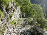 13
13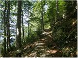 14
14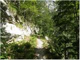 15
15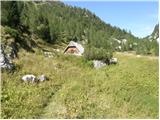 16
16 17
17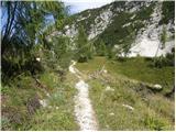 18
18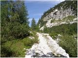 19
19 20
20 21
21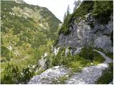 22
22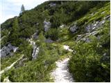 23
23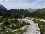 24
24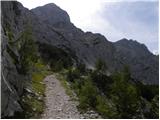 25
25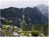 26
26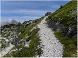 27
27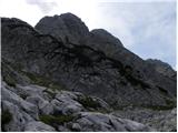 28
28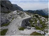 29
29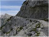 30
30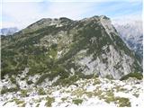 31
31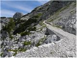 32
32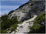 33
33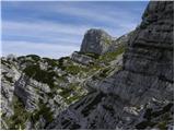 34
34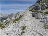 35
35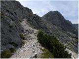 36
36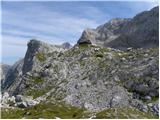 37
37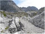 38
38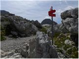 39
39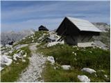 40
40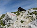 41
41 42
42 43
43
Discussion about the trip Trenta - Zasavska koča na Prehodavcih
Show older messages
|
| LISO15. 06. 2008 |
Hello everyone. Since I'm going on the tour Trenta-Prehodavci-Veliko Špičje, I'd like to know if there's any new snow or old snow towards Špičje.
|
|
|
|
| Tadej15. 06. 2008 |
New [snow,] good 20 cm, and there's still quite a bit of old [snow].
|
|
|
|
| LISO15. 06. 2008 |
Then a little patience. Thanks
|
|
|
|
| počasni29. 06. 2008 |
Hello! I'm wondering if it's very hot here in summer or if there's any shade along the path?
|
|
|
|
| triglavski29. 06. 2008 |
From Log in Trenta or Zadnjica there is shade early in the morning, higher up you can find shade behind some rock, but heat is a relative term, so it's hard to answer. At 2000 m it can rise to 18 to 20 degrees, at 2500 to 16, but that's already very exceptional.
|
|
|
|
| Tadej29. 06. 2008 |
There is quite a bit of shade in the morning hours, as the path mostly runs along the western slopes.
|
|
|
|
| nincokl4. 07. 2013 |
Mountain lover wonderful pictures, I plan to do this trail soon, wondering if you descended the same path and how long ascent to v.špičja takes at moderate pace...thanks.....once again--pictures are divine!!
|
|
|
|
| ljubitelj gora4. 07. 2013 |
Trenta-Prehodavci-Špičje-Veliko jezero-Prehodavci-Zadnjiški Ozebnik and back to Trenta, for the tour about 12 hours, but if not mistaken from Trenta to Veliki Špič 7 hours.
|
|
|
|
| nincokl5. 07. 2013 |
Thanks for the information. Best regards.
|
|
|
|
| vesnapl5. 07. 2013 |
Wonderful pictures!! 
|
|
|
|
| Pohodnica562. 08. 2013 |
Mountain lover, how about shade, if I start between six and seven in the morning, I'll be to Prehodavci already quite "done"
|
|
|
|
| vavtora2. 08. 2013 |
Wonderful pictures - we have to see them ourselves - thanks
|
|
|
|
| laszlo4. 06. 2014 |
Hello!
I'm not an experienced hiker. Two years ago I climbed to Dvojno Jezero from Slap Savica - but I really feared at some parts.
So this time I would like to be safe, if that is possible. This track seems to be very good. I would like to ask if this is all? No dangerous parts?
Because this road is very similar:http://www.hribi.net/izlet/zadnjica_zasavska_koca_na_prehodavcih_pot_mire_marko_debelakove/1/175/4112 , but starting at 39th photo, I definitely have to think again. These roads are this different considering the danger zone?
Thanks a lot!
|
|
|
|
| viharnik4. 06. 2014 |
The mountain path Mire Marko Debelakove is considered for passing the terrace through the entire Kanjavec mountain from Dolič mountain house to Zasavska house. Beautiful passing, but the exposed one is now still under deep snow and should be very dangerous. Normal way from north-west side leads to Zasavska koča from Zadnjica valley - Čez Dol saddle - Zasavska koča. This path is also under snow, so must have with you all winter equipment. From Savica is now the easiest ascent, because steep Komarča is free of snow. Bye!
|
|
|
|
| viharnik4. 06. 2014 |
Because of still deep heavy snow in Julian Alps, I recommend that you explore unique Fužinske planine under Bohinj lake. On this way you can visit Pršivec, Ogradi, Kreda mountains, or just make one circle around all autochthon original highland small villages and untouched ancient forest.
|
|
|
|
| laszlo5. 06. 2014 |
Thanks Viharnik! I will go in June, so the snow probably won't cause any problem. I only fear the dangerous parts, like via-ferrata.
|
|
|
|
| Saš19675. 06. 2014 |
Laszlo, this path is by Slovenian alpine standards marked as a "light marked path", so there is no "iron" on the road and no exposed dangerous parts. Anyway, for starters it should not be underestimated since you have 1451 height meters and more than 4 hours of walking. Notice that this is only half part, you must descend either. When you're on Prehodavci you have plenty of possibilities to descend. Before starting the route always check the weather conditions and conditions on the road. Just like viharnik said there is a good part of this road still under snow. I wish you a nice trip.
|
|
|
|
| laszlo5. 06. 2014 |
Yes, you are right Saš, this is just the half of the road. Would be great to sleep up there, but my wife is hesitating, she is against it a bit because wants to take a shower every evening I'll try to check which other safe routes there are to descend to the car parking.
I'm very happy to find this page, after three days of constant searching. You are all very kind.
THANKS!
|
|
|
|
| Saš19675. 06. 2014 |
Without sleeping it's better to return the same way you came. But when you decide to sleep then you can descend through the valley of seven Triglav lakes (Dolina Triglavskih jezer). It's one of the most beautiful valleys in Julian Alps and you will see almost all Triglav lakes. You can then spend the night in Koča pri Triglavskih jezerih by Dvojno jezero - where you've been. It's 2:15 hours from Prehodavci.
On the second day you can descend further through Komna to Bohinj lake, actually you end up near the fall - Slap Savica. I recommend that you buy a map of the area (Bohinj, Julian Alps) so you will know how to orientate.
|
|
|
|
| laszlo5. 06. 2014 |
Yes, two years ago I had already learned that it was a mistake not to spend those 10 euros for the map, so now I surely will buy one
If we can sleep up there, then I would like to approach Triglav somehow. Only in a safe way, if that is possible. If not, then the seven lakes, yes! Unfortunately we can't finish at Slap Savica, because the car will be in Trenta, and our apartment in Bovec. Thanks for your help!
PS: Where can I find info about the difficulty of the routes? (Because you mentioned this "easy marked path".)
|
|
|
|
| SunBurned5. 06. 2014 |
You find it in the path description (above the photos).
"Zahtevnost" means difficulty.
"Lahka označena pot" means easy marked path (just walking, no dangers).
"Delno zahtevna označena pot" means slightly difficult marked path (just a few meters of iron and/or some steep parts).
"Zahtevna označena pot" means difficult marked path (not for beginners any more).
There are also others but don't really apply to your needs.
|
|
|
|
| SunBurned5. 06. 2014 |
And one more thing:
Path difficulty can also be quickly recognized on the map. Continuous line means easy or partially difficult path, broken line means not for beginners/hikers.
|
|
|
|
| Saš19675. 06. 2014 |
Laszlo, I sent you a personal message.
|
|
|
|
| laszlo5. 06. 2014 |
Thanks to all of you for this kindness!
Two months ago I booked our apartment in Bovec.
I was emailing with the house owner. I wrote her that I'm in love with Slovenia and the people there, because they are so positive, relaxed and warm-hearted. She said that she
is surprised and she doesn't think this way
I will tell her my story at this wonderful forum...
|
|
|
|
| Mara666. 06. 2014 |
Hello,
how is the trail? Is it sufficiently passable and safe and how much snow is there, if anyone has gone to the hut at this time of year
Thanks
|
|
|
|
| eftomi18. 06. 2014 |
Like Maro66, I'm also interested in the condition (from Trenta). I saw on PZS that the hut opening is planned for 21.6.
Thanks!
|
|
|
|
| mirank18. 06. 2014 |
As seen last (8.6.) Sunday from the clear summit the path from the saddle onwards is still completely under snow. Since last year at this time there was snow cover up to halfway from Zadnjica to the saddle, I assume it's the same or even more under snow there this year too. Namely, last year a good part of the path above the saddle (mulatiera) was already clear during our ascent.
|
|
|
|
| eftomi18. 06. 2014 |
Thanks, mirank. The friendly hut warden just confirmed this to me; winter gear required (ice axe and crampons).
Hut opens on Saturday, beds and food available, but not full service yet.
|
|
|
|
| Pohodnica5629. 08. 2014 |
Tomorrow will be a beautiful day for a slightly longer tour, at least I hope Has anyone walked this path in the last few days? Is there still any snow somewhere? Thanks for info. Safe steps everyone.
|
|
|
|
| spelinda20. 06. 2016 |
Does anyone perhaps know the conditions from Trenta to Zasavska koča? Is there still any snow? Equipment?
|
|
|
|
| spelinda24. 06. 2016 |
Hello!
Does really no one know what the conditions are like on the path from Trenta to Zasavska koča na Prehodavcih? Is the hut already open?
Thank you.
|
|
|
|
| navdušena19. 09. 2016 |
Nothing describes the path from Trenta to Zasavska koča na Prehodavcih past planina Krotica. Has anyone walked this path? Is it maintained, marked - how long does the ascent take?
Thanks for info.
|
|
|
|
| Janez Seliškar19. 09. 2016 |
Which path is described in this post, if not exactly the one you are asking about?
Just read it, set off along it and it will take you straight up to Prehodavci.
|
|
|
|
| anazala14. 06. 2021 17:09:15 |
Next week we're heading to Boško kotlina. We'd like to go on foot to Zasavska koča. I'm interested. Can you get from the hut to the Triglav lakes. How much path is left. Is it easy or not.
|
|
|
|
| gor_nik14. 06. 2021 18:49:20 |
@anazala
Good grief; such a short note and so many mistakes.
I don't know from where you'll go to Zasavska koča. But let's say you're already at the hut and want to go to the Triglav Lakes. The nearest lakes are about 10 to 15 minutes from the hut (Jezero pod Vršacem, Rjavo jezero). The farthest is about 3 hours walk (Črno jezero). In between (along the path) lie the other lakes.
Regarding the difficulty of the path, it's thankless to rate, as it's more about individual judgment. But for me, the path is definitely easier and nicer than to Zasavska koča from any side.
|
|
|
|
| blazzm14. 06. 2021 19:34:15 |
anazala, based on the question I dare to conclude that you're not the most experienced hiker yet. I would recommend that instead of such a question on the forum, you take a proper map in hand and look for yourself if there's a path from Prehodavci to your desired goal.
Reading the map will help you or is even necessary later on the tour itself. And look at the descriptions of other paths to Zasavska koča. You'll quickly see that the "main route" goes right past there. The path is easy enough, but in your place I would rather ask about conditions. I don't know the conditions there, but I know there's still a lot of snow in the Julians and I expect there will still be quite a bit next week.
Best regards and good luck
|
|
|
|
| anazala14. 06. 2021 22:27:21 |
It's true. I've just started hiking in the mountains. I don't dare much. I looked at the map. It's too much for me. Some say it's easily accessible. Others say it's dangerous. Thanks for the advice. Too much for a 14-year-old.
|
|
|
|
| rozka14. 06. 2021 22:42:17 |
Note: there's still snow to/on Prehodavci... and since I can't upload the picture here, check under the Zapotoški vrh forum, picture no. 37...
|
|
|
|
| zdejan14. 06. 2021 23:32:11 |
From Trenta there are two steep paths up to Zasavska koča na Prehodavcih. From the hut to the lakes it then goes slightly downhill. If you want to return to the starting point the same day, you need to be very well physically prepared, experience also helps.
|
|
|
|
| LadyS2. 08. 2022 15:54:38 |
We started from the starting point, where we also left the car in the early morning hours. Before the barrier, there is space for 3 passenger cars. The trail is very well marked, appropriate footwear and a sufficient amount of water are obligatory. The trail through the forest section drags on, so you really look forward to the trail through the scenic valley below Veliki Špičje. The most demanding is the last part of the trail, where caution is needed, slips into the abyss are possible. Hiking poles are highly recommended. The view from the top is fantastic, worth all the efforts, and the food in the hut is excellent. I can only praise the staff. We returned the same day via the same trail, but unfortunately met quite a few inadequately equipped hikers (foreigners). The descent is demanding if returning the same day, as the entire tour takes several hours. The hike is not suitable for beginners. For lovers of alpine vegetation, this hike will be a real feast for the eyes, edelweiss also grow along the trail.
|
|
|
|
| winni10. 12. 2023 22:58:56 |
|
|
|
|
| DVas11. 12. 2023 08:11:50 |
|
|
|
|
| turbo11. 12. 2023 08:17:44 |
On PZS it says the hut is closed and sleeping is possible in the nearby winter room or bivouac 
|
|
|
|
| miri11. 12. 2023 08:27:47 |
Who is the video for? Ashamed of his mother tongue or just packing it in English? 
|
|
|
|
| mukica11. 12. 2023 08:27:51 |
Oh dear, the young lad got lucky, maybe the next ones won't....
|
|
|
|
| Daaam11. 12. 2023 08:35:36 |
#miri is looking for sponsors/attention, lately he's popping up everywhere on all channels- in any case, this really isn't okay if the winter room/bivouac is really locked. This isn't right and this isn't the way to get rid of unwanted guests..
|
|
|
|
| nejcf11. 12. 2023 08:36:52 |
Miri, maybe the young lad wants to reach viewers across the border too (if it's not obvious, English will bring him more than Slovenian). It's clear that logic doesn't work for you in this area.
|
|
|
|
| julika11. 12. 2023 16:35:58 |
There is also an option to speak Slovenian with English subtitles, so it would be understandable to everyone and provocative or not  
|
|
|
|
| turbo11. 12. 2023 16:49:21 |
It would be even more noticeable in Hungarian!
|
|
|
|
| karibu11. 12. 2023 21:07:20 |
How come the bivouac is locked?!
|
|
|
|
| rensul11. 12. 2023 21:51:19 |
Today I contacted the mountaineering association that manages the winter room via email, and their response without additional explanations: The winter room is open.
|
|
|
|
| DVas11. 12. 2023 22:19:42 |
It looked like it yes
|
|
|
|
| Roman2912. 12. 2023 06:57:48 |
I also contacted them yesterday via email and via message, but no response.
|
|
|
|
| UB7712. 12. 2023 09:13:34 |
Maybe it's locked so that no one cooks kerosene again, like on Korošica...
|
|
|
|
| Jure 212. 12. 2023 09:28:33 |
The only possibility that the bivouac at Prehodavcih is locked is that they forgot to unlock it when closing the hut. If someone has slept there this year, it's unlocked.
This raspberry guy makes a "sensation" out of every thing. Now there's a big discussion on forums.
You go up, clean the area around the door, check if it's frozen or the door has sagged (which has happened before) and report to the PD to go check or repair.
Jure Brečko
Former caretaker of Zasavska koča
|
|
|
|
| mirank12. 12. 2023 10:07:29 |
Although I don't think that's it, I have to say that idiots messed up the open doors for us. Because they opened outwards and the hinges weren't visible, this crowned donkey insisted on opening the doors inwards. The consequences were visible everywhere....
|
|
|
|
| karibu12. 12. 2023 17:21:01 |
The hut closed on 1 October, I was up there on 6 October - at that time the bivouac was still unlocked
|
|
|
|
| ljubitelj gora14. 12. 2023 11:43:49 |
someone wrote in a comment under a YouTube video that the doors got frozen stuck from the cold so they were unlocked.
|
|
|
|
| Jernej96815. 12. 2023 14:50:40 |
For the author of the description, I have a suggestion to correct the starting point name from "Trenta" to "Log v Trenti". This name, although no longer officially used for a long time, more accurately determines the starting point. Otherwise, the starting point is also marked with coordinates, but still it's right to have it with the name too. Trenta can mean the valley or the settlement. The Trenta valley from the direction of Bovec starts soon after Bovec, the Trenta settlement starts about 5 km before the mentioned starting point and ends somewhere there at the source of the Soča.
|
|
|
|
| turbo15. 12. 2023 16:29:07 |
More precisely it's Na Logu v Trenti. Also the only correct one.
|
|
|
|
| taubi6627. 12. 2023 17:19:05 |
Maybe someone knows how it is with the winter room for New Year's Eve. Every year I look for a bivouac where there won't be a crowd. Preferably alone. And... what's the access from Trenta (not Zadnjice)?
|
|
|
|
| Benjamin.K27. 12. 2023 19:24:54 |
The issue with the locked door of the winter room at Prehodacvih has been resolved. With the intervention of dedicated guides, they fixed the door problem. Now they open normally; at that time they were frozen due to ice rain that froze the seals. They checked the photovoltaics, camera, generator and repaired the external toilet, which the wind started to strip - tearing off the aluminum roofing. So, whoever comes, enjoy it and take out the trash and tidy up the room as you received it. Good luck, health and many beautiful days in the high mountains to everyone. Manager of Zasavska koča na Prehodavcih.
|
|
|
|
| taubi6627. 12. 2023 23:02:25 |
Benjamin, thanks for the info. But still, what's the path from Trenta like?
|
|
|
|
| mukica28. 12. 2023 07:48:02 |
Benjamin, thank you for all your effort and care so that hikers can feel good
Happy 2024 to all
|
|
|
|
| Benjamin.K28. 12. 2023 09:24:24 |
Hello. From the saddle onwards the snow is about half a meter deep. I wasn't there, but they went from Zeleni grivi onwards along the winter route not the path, because the path is too exposed. Caution is needed of course especially downhill due to crevices, holes, the snow is not yet spring-like and settled. Safe steps and happy 2024.
|
|
|
|
| taubi6628. 12. 2023 13:03:48 |
benjamin, thanks. I'll follow the tracks.
|
|
|
|
| Daaam28. 12. 2023 13:17:31 |
taubi66 - in winter on dangerous terrain following unknown tracks can be much more dangerous than it looks - you never know who walked, with what purpose and where they went.. what if you "follow" the track of a top alpinist? how far do you dare go... or a lost tourist who doesn't even know where to go. if you don't know the individual "winter passages, variants" then it's best to go first with someone who knows the path. Also the tracks that the mentioned guys made you probably won't find anymore when you head up - did you check the weather for New Year's Eve?
|
|
|
To post a comment you must log in:
If you do not yet have a username, you must first
register.