Torka - Altemaver (Ratitovec)
Starting point: Torka (1160 m)
| Latitude/Longitude: | 46,2309°N 14,0807°E |
| |
Walking time: 1 h 35 min
Difficulty: easy marked way
Elevation gain: 518 m
Elevation difference along the route: 530 m
Map: Škofjeloško in Cerkljansko hribovje 1:50.000
Recommended equipment (summer):
Recommended equipment (winter): ice axe, crampons
Views: 47.934
 | 3 people like this post |
Access to starting point:
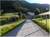
First, we drive to Škofja Loka, and then we continue driving towards Železniki and further towards Podbrdo. Soon (approximately 2 to 3 km) after Zalim Log, we will notice signs for the villages Ravne and Torka, which direct us to the right onto an ascending road. The steep and narrow road brings us higher to Ravne, where at the crossroads we continue on the right road, which we then follow to the hamlet or farm Torka, which is the starting point for our tour. Because at the starting point there are no suitable parking spots, it is best to turn right at the farm and drive a further good 100 m on the forest road and then park at a suitable place beside the road.
Route description:
From the farm we continue on the right road, which in a gentle ascent crosses the slopes towards the right. The road then turns into the forest, where past a smaller spring and the bottom station of the cargo cableway that leads to Ratitovec, it brings us to the spot where the mountain signpost for Ratitovec directs us left onto an ascending cart track (if we continue on the road, we arrive at the saddle Po(v)den). After a short ascent, the marked path from the village Prtovč (path over Po(v)den) also joins from the right, and we continue left and continue on the cart track for a few more minutes.
When the cart track ends we continue on the well-beaten mountain path, which gradually begins to ascend more and more steeply. The path, which initially runs through the forest, soon brings us to bare slopes, where it ascends even more steeply. The steep and increasingly scenic path, which runs across steep slopes that are dangerous for slipping and snow avalanches in winter, higher up suddenly flattens and turns left, bringing us to the pasture areas of Ratitovec. From here follows about 5 minutes of easy walking, and the path, from which beautiful views open up to Porezen and the surrounding peaks, brings us to the Krekova koča na Ratitovcu.
From the hut we continue on the marked path in the direction of Soriška planina. The path first descends slightly to the winter bivouac, where the path from the mountain pasture Pečana joins from the right, and we continue straight to the watering place for animals, where the path stops descending. The path ahead begins to ascend more steeply along the pasture fence and after a few minutes of ascent brings us to the eastern forepeak of Altemaver. A short descent follows, then the marked path turns slightly to the right. Just at the spot where the marked path leading towards Soriška planina turns slightly to the right, we leave it and continue the ascent on the clearly visible path in the direction of the summit Altemaver, which continues along the ridge of Ratitovec. We then follow this scenic path to the highest peak of Ratitovec, which we reach after a few dozen steps of further walking.

Photos:
 1
1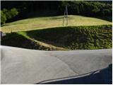 2
2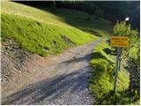 3
3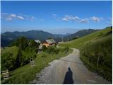 4
4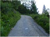 5
5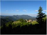 6
6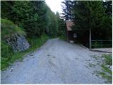 7
7 8
8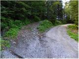 9
9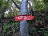 10
10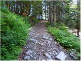 11
11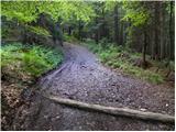 12
12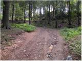 13
13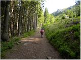 14
14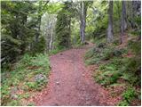 15
15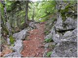 16
16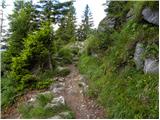 17
17 18
18 19
19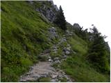 20
20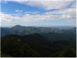 21
21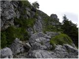 22
22 23
23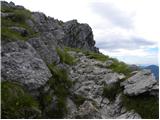 24
24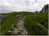 25
25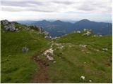 26
26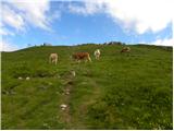 27
27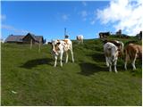 28
28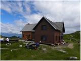 29
29 30
30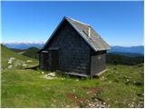 31
31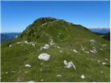 32
32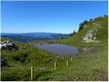 33
33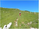 34
34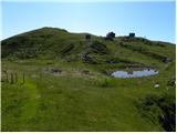 35
35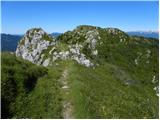 36
36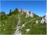 37
37 38
38 39
39
Discussion about the trip Torka - Altemaver (Ratitovec)
|
| trdi10. 09. 2012 |
With the car you can drive a couple hundred meters higher to the Povden saddle and then it's one hour walk to the hut.
|
|
|
|
| Daaam10. 09. 2012 |
...Lucky there's no road to the hut @trdi: is it so bad to walk a couple minutes more...? @trdi: is it so bad to walk a couple minutes more...?
|
|
|
|
| GregorC10. 09. 2012 |
Exactly. All that's missing is for Povden to be full of trash too
|
|
|
|
| zanesenjak11. 09. 2012 |
Yes, but the road from Zalega Loga to Povdna is terribly long. It's much more worthwhile to go from Prtovča.
|
|
|
|
| Daaam12. 09. 2012 |
No problem parking at Torka, it's just nonsense to push further with the car on the forest road...
|
|
|
|
| MiaB.17. 03. 2021 |
Which is the best trail if coming from Primorska to Ratitovec and Krekova hut? Thanks.
|
|
|
|
| padez17. 03. 2021 |
Depends on which place you're from. Primorska stretches from Dragonja to Vršiča...
If from Vipavskega, Krasa or Obala then you have motorway, best access to Škofje Loke and further on regional road to starting point. From Gorice to Podbrda and over Petrovo Brdo to starting point.
|
|
|
|
| MiaB.17. 03. 2021 |
Best thanks... Yes, I should be more precise.. Coming from Goriška end. After Petrovo Brdo which place to follow? Torka or Zgornje Danje? Coming from Goriška end. After Petrovo Brdo which place to follow? Torka or Zgornje Danje?
|
|
|
|
| GregorC18. 03. 2021 |
At Petrovem brdu go towards Sorica and Soriška planina. Then follow the signs for Zgornje Danje (actually we call it Dajne Torka is then a few km further from Dajne. You can make a loop. From Zg. Dajne along the described path to the hut, then descent along the path over Poden to Torka and along the road through the hamlet Zabrdo back to Zg. Dajne.
|
|
|
|
| MiaB.18. 03. 2021 |
Super, thanks GregorC
|
|
|
To post a comment you must log in:
If you do not yet have a username, you must first
register.