Dolina Krma - Dom Planika
Starting point: Dolina Krma (944 m)
| Latitude/Longitude: | 46,3851°N 13,9071°E |
| |
Walking time: 4 h 30 min
Difficulty: easy marked way
Elevation gain: 1457 m
Elevation difference along the route: 1471 m
Map: Triglav 1:25.000
Recommended equipment (summer):
Recommended equipment (winter): ice axe, crampons
Views: 61.748
 | 2 people like this post |
Access to starting point:
We leave the Gorenjska motorway at the Hrušica exit and follow the road ahead towards Kranjska Gora. Just before the village of Dovje, the road to Mojstrana (Vrata, Kot and Krma) branches off to the left from the main road. We follow the road ahead towards the village of Radovna and the valleys of Krma and Kot. The relatively steep road then takes us past the TNP sign, after which the road soon flattens and brings us to a junction, where a macadam road into the Kot valley branches off to the right. We continue straight on the road, which starts to descend. In the middle of the descent, the road into the Krma valley branches off to the right (straight to Radovna). A little further on, we come to the next junction, where we continue right in the direction of Krma. The macadam road then brings us to the Kovinarska koča hut, and we follow it further. The occasionally somewhat rougher road then brings us to the parking lot in front of the gate.
Route description:
From the last parking lot in the Krma valley, called Pri lesi, we continue along the poorer road that continues up the valley and soon brings us to a clearing, where we bypass the nearby building on the left side. We continue along the gravel path that approaches the torrent and crosses it a little further on. On the other side of the torrent, the path enters the forest and first ascends gently, then quite steeply for some time. Higher up, we leave the forest for the belt of dwarf pines and shrubs, and from the path beautiful views open up of the nearby walls of the peaks, which on the other side descend more gently towards Pokljuka.
Higher, at an altitude of a little over 1400 m, the path temporarily flattens and brings us to the beautiful grassy plain Vrtača.
After the grassy section, the path starts ascending again along a section that is often quite slippery here, and it flattens on the Malo polje plain.
Here the path turns right and forks.
To the left branches off the path towards Bohinjska vratca and Vodnikov dom on Velem polju, while we continue straight along the foot of Vernar easily to the spring with trough.
After the trough the path forks, and we continue straight on the marked path (left unmarked shortcut to planina Zgornja Krma). There follows some moderate, higher also somewhat steeper ascent through sparse, partly larch forest. Higher the path turns left and flattens, and from the left the previously mentioned shortcut joins us.
After the junction of both paths we soon arrive at the shepherd's hut on planina Zgornja Krma, called Prgarca.
From here the path in moderate ascent continues towards the west and brings us to the last spring along the path, and above the spring the path forks again.
To the left the path continues over Kurica towards Konjsko sedlo and Dom Planika pod Triglavom, to the right paths lead to Kredarica and Staničev dom pod Triglavom.
We choose the left path, which leads below the summit of Kurica and begins to ascend ever more steeply. A few minutes higher we arrive at a short rocky step, where the path becomes even steeper and especially when wet also dangerous for slipping. Above the rocky step the steepness gradually eases, the path leads us below the walls of the nearby peak Oklo, and the path also turns somewhat more to the left. A little further the slope temporarily becomes somewhat steeper, and we continue in a gentle traversing ascent to Konjsko sedlo, where there is a junction of several paths.
We continue in the direction of Dom Planika pod Triglavom (left Pokljuka, Vodnikov dom on Velem polju, Uskovnica and Stara Fužina, right Triglavski dom na Kredarici and Dom Valentina Staniča pod Triglavom) and begin to ascend quite steeply towards the west. For some time we approach Mokra skala (2266 m), then the path turns right and passes onto an indistinct ridge, where it temporarily flattens. The marked path higher bypasses a small sinkhole on the right side, then begins to turn to the left. There follows another approximately ten minutes of ascent, and with beautiful views of the Triglav massif and the surrounding mountains we arrive at Dom Planika pod Triglavom.
Krma - Zgornja Krma 2:30, Zgornja Krma - Konjsko sedlo 1:00, Konjsko sedlo - Planika 1:00.

Photos:
 1
1 2
2 3
3 4
4 5
5 6
6 7
7 8
8 9
9 10
10 11
11 12
12 13
13 14
14 15
15 16
16 17
17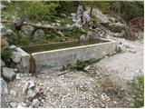 18
18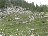 19
19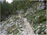 20
20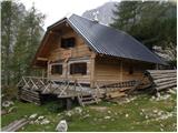 21
21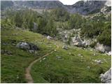 22
22 23
23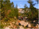 24
24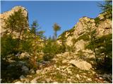 25
25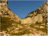 26
26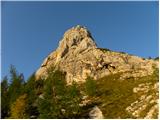 27
27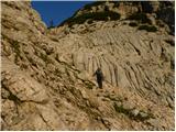 28
28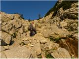 29
29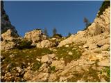 30
30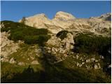 31
31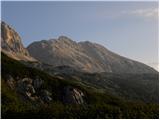 32
32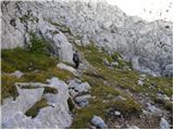 33
33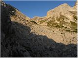 34
34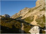 35
35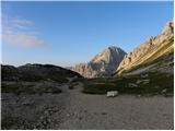 36
36 37
37 38
38 39
39 40
40 41
41 42
42 43
43 44
44 45
45 46
46 47
47 48
48 49
49
Discussion about the trip Dolina Krma - Dom Planika
|
| heinz24. 10. 2008 |
I'm interested if the conditions on this path currently already require winter gear - crampons. How much snow and ice is there?
Tomorrow 25.10. I plan to go to Planika.
Thanks for the answers!
|
|
|
|
| Tadej24. 10. 2008 |
Currently the path is snow-free, so no winter gear needed.
|
|
|
|
| heinz26. 10. 2008 |
Tadej, thanks for the information!
It was indeed completely dry, and even as it looked, it would be the same all the way to the top. Interesting how quickly the snow disappears.
|
|
|
|
| kungočan9. 06. 2011 |
I'm interested from when Planika is open, because of
reservations?
|
|
|
|
| m35759. 06. 2011 |
On 8.6. I called the PD, where they told me they expect to start operating around 20.6., possibly even earlier. Due to bad weather these days, they haven't sent the staff to the hut yet. Below are the phone numbers.
Best,
matej
Hut keeper: Irena Klinar 051/614-773
PD: 04/ 57 44 069
|
|
|
|
| kungočan12. 06. 2011 |
Thanks Matej for the info and also for the tel.
numbers. I'll call when the weather settles a bit.
Best,
Jure
|
|
|
|
| Pohodnica5617. 07. 2011 |
With my hiking companion, we would like to do a four-day tour, from Planina Blato to Prehodavci, then to Tržaška koča na Doliču and onwards to Dom Planika and perhaps also to Kredarica. Depending on the weather and fatigue.
Please for a bit of help, is the path from Dolič to Dom Planika via Šmarjetna glava very demanding/pegs, cables/. On Hribi I read that it is partially demanding, but from the pictures I can't judge, we wouldn't want to turn back somewhere in the middle because our knees would shake from fear or something unexpected happens to us. We have good fitness, quite a lot of hikes and little experience with pegs and cables. Any answer will be welcome and we will gladly follow the advice of the more experienced.
Nice greetings to all mountain friends.
|
|
|
|
| pepita25. 07. 2011 |
Pohodnica56,
I'm setting off for the Triglav Lakes from the Soča direction myself, specifically from Vrsnik (Vas na skali) via Velika vrata to the hut at Triglav Lakes and then to Prehodavci and Dolič. Then we'll see. Depending on fatigue, will, weather.
There are many paths where you don't need to be afraid. The important thing is to enjoy the mountains.
Best regards.
|
|
|
|
| mojcej'7225. 07. 2011 |
No matter what anyone does in the mountains, they should always check the possibility of overnight stay beforehand, even if the demanding plan doesn't succeed. In summer, the huts are quite occupied. They shouldn't turn away a hiker from staying in the hut, so in extreme cases they use emergency options on benches in the common area, but hikers can do a lot themselves if they organize the tour well in advance according to fitness and weather and reservation of accommodation.
|
|
|
|
| polo1125. 12. 2017 |
In the summer months I plan to take my wife as close as possible to Triglav. I'm interested if there are any pegs or steel cables on this path, because she is afraid of heights.
|
|
|
|
| Daaam25. 12. 2017 |
No pitons or fixed ropes.. but you can also take it to Kredarica.. same easy route from Krma. It'll be even closer to Triglav
|
|
|
|
| turbo26. 12. 2017 |
@polo11
If you want as close as possible but not to the top, consider also the route from Zadnjica to Dolič and from there under the overhang. Wonderful route, scenic, where it gets crowded it's less here than on the Gorenjska side 
|
|
|
|
| Grenaleva17. 07. 2018 |
Has anyone been there these days? How is the snowfield on Kurica? More interested in the way down. Thanks
|
|
|
|
| Zmagolajf11. 09. 2025 12:03:39 |
Hi
is anyone going on this path tomorrow by any chance?
|
|
|
To post a comment you must log in:
If you do not yet have a username, you must first
register.