Dolina Kot - Visoka Vrbanova špica (Lojze Rekar route)
Starting point: Dolina Kot (950 m)
| Latitude/Longitude: | 46,4157°N 13,8977°E |
| |
Route name: Lojze Rekar route
Walking time: 5 h 10 min
Difficulty: very difficult marked way
Via ferrata: B/C
Elevation gain: 1458 m
Elevation difference along the route: 1580 m
Map: Tiglav 1:25.000
Recommended equipment (summer): helmet, self belay set
Recommended equipment (winter): helmet, self belay set, ice axe, crampons
Views: 75.566
 | 3 people like this post |
Access to starting point:
We exit the Gorenjska motorway at the Hrušica exit and continue along the road in the direction of Kranjska Gora. Just a little before the village of Dovje, a road branches off to the left from the main road leading to Mojstrana (Vrata, Kot and Krma). We continue along the road in the direction of the village of Radovna and the Krma and Kot valleys. The relatively steep road then takes us past the TNP sign, after which the road soon levels out and brings us to an intersection, where a gravel road branches off to the right into the Kot valley (straight ahead Radovna and Krma). We then follow this occasionally somewhat poorer road to the parking lot, where we also notice the mountain direction signs.
Route description:
From the end of the road we continue along the wider marked path in the direction of Staničev dom and Kredarica, which ascends gently through the forest. After a few minutes we arrive at the Kotarice gravel area, across which we cross transversely to the other side, where the path reappears.
This is followed by some gentle walking through the forest, after about half an hour of walking the path quickly becomes quite steep and, due to often quite slippery ground, also dangerous for slipping, especially on the descent, so extra caution is required on this section. On this part, we are helped on the more difficult places by a few pitons as well. Higher up the steepness eases and the path brings us to the spring Pri studenčku, which however dries up in dry days.
Here an unmarked path branches off to the left towards Macesnovec, we continue straight across the torrent, and after the torrent we cross another short secured but not particularly difficult place. This is followed by an ascent through a belt of dwarf pines, higher up we arrive in an increasingly rocky world, where we can already see a larger boulder nicely in front of us. Here our path is crossed quite inconspicuously by the PP path (Planica - Pokljuka path), while we ascend to the aforementioned boulder called Debeli kamen with increasingly beautiful views.
At Debeli kamen the dwarf pines occasionally end completely and we continue through an increasingly high-mountain world, where we mostly ascend on scree. On this section, looking back, a nice view opens up to Ladja (Ladja is a distinctive precipitous promontory or peak overgrown with dwarf pines that rises above the Kot valley), while we then ascend to a marked junction, where the climbing path to Vrbanove špice, or the Lojze Rekar path, branches off to the right.
We continue in the mentioned direction (left Dom Valentina Staniča and Rjavina) and already after a few meters the path turns right again, where with the help of some steel cables and pitons we cross steep rocky slopes below Vrbanove špice. Then we turn left and in a slight ascent we cross still quite steep slopes. Soon after that we turn left again and with the help of some protections we begin to ascend steeply on a slope partially overgrown with grass and dwarf pines. The path then turns slightly to the right and brings us to the ridge, where a view of Cmir opens up. Here we turn left and with the help of pitons and steel cables we begin to ascend along a steep and narrow ridge, which soon brings us to a junction. From the junction we head left (slightly right the path continues towards Visoka Vrbanova špica) and with the help of some pitons and bolts we reach the summit of Spodnja Vrbanova Špica. The summit also has a stamp and a summit book.
From the summit of Spodnja Vrbanova špica we then return back to the junction where we follow the signs for Staničev dom. The path ahead in a slight descent bypasses the summit of Spodnja Vrbanova špica on the northern side and brings us via a fairly wide ledge back to the ridge. From here we have only a few meters to Plesišče (2244 m) across which a marked path does not lead, but it is well marked with cairns. Plesišče is a large flat slab from which there is a wonderful view of Spodnja and Visoka Vrbanova špica, Rjavina and Cmir. Plesišče is interesting also because in the middle of the narrow and precipitous ridge of Vrbanove špice no one expects such a large flat slab.
The path then runs along the ridge and first ascends slightly, then with the help of steel cables and pitons descends to a smaller natural window through which Cmir can be nicely seen. From here we then climb with the help of pitons over a slightly overhanging chimney, which is followed by a descent that is also slightly overhanging on a short section. Then we ascend through steep rock, which via a well-secured narrow and exposed ledge brings us to another window. Here we again begin to ascend with this time somewhat more numerous pitons. This is followed by an ascent with the help of steel cables through broken rock to a grassy slope below the summit. From here we have only a few minutes of easy walking to the summit of Visoka Vrbanova špica.
Starting point - Pri studencu 1:25, Pri studencu - Debeli kamen 1:20, Debeli kamen - turnoff for Vrbanove špice 0:30, Turnoff for Vrbanove špice - Spodnja Vrbanova špica 0:45, Spodnja Vrbanova špica - Plesišče 0:15, Plesišče - Visoka Vrbanova špica 0:55.

Along the route: Pri studencu (1330m), Debeli kamen (1810m), Odcep za Vrbanove špice (2005m), Odcep na Spodnjo Vrbanovo špico (2279m),
Spodnja Vrbanova špica (2299m), Plesišče (2248m)
Photos:
 1
1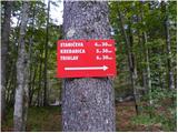 2
2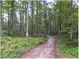 3
3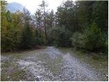 4
4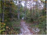 5
5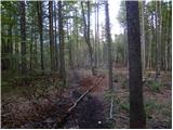 6
6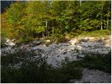 7
7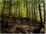 8
8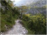 9
9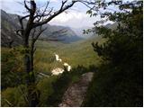 10
10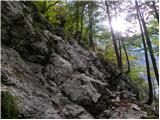 11
11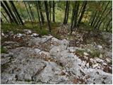 12
12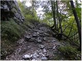 13
13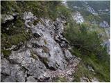 14
14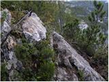 15
15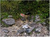 16
16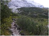 17
17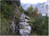 18
18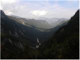 19
19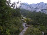 20
20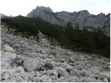 21
21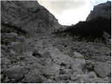 22
22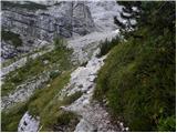 23
23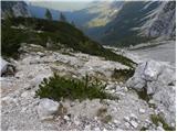 24
24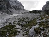 25
25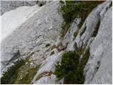 26
26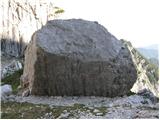 27
27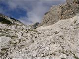 28
28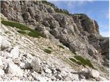 29
29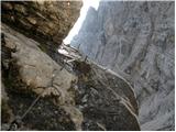 30
30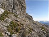 31
31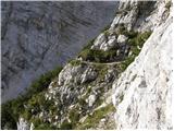 32
32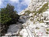 33
33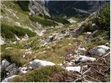 34
34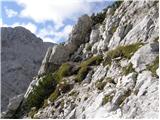 35
35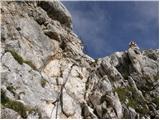 36
36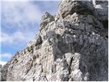 37
37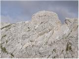 38
38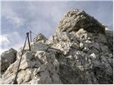 39
39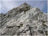 40
40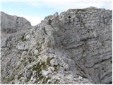 41
41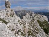 42
42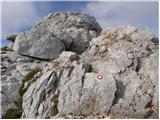 43
43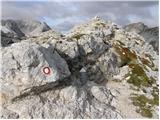 44
44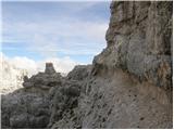 45
45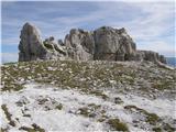 46
46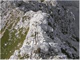 47
47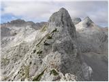 48
48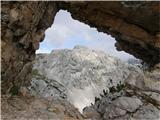 49
49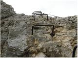 50
50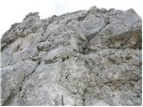 51
51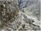 52
52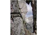 53
53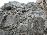 54
54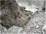 55
55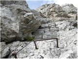 56
56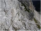 57
57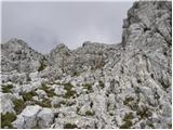 58
58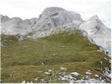 59
59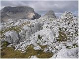 60
60
Discussion about the trip Dolina Kot - Visoka Vrbanova špica (Lojze Rekar route)
Show older messages
|
| Gost11. 02. 2008 |
I plan to visit this beauty in summer. Judging by the photos, the path seems well secured. Am I right? With which secured path can I compare it?
best, Franci
|
|
|
|
| Gost11. 02. 2008 |
The path is adequately secured.
However, it is quite climbing-intensive, you can compare it to Dolgi hrbet. Best
|
|
|
|
| Gost12. 02. 2008 |
Hello,
I'm also interested in crossing via the Vrbanove špice, but I'm getting very different information.
I've already done Dolgi hrbet. Not for the vertiginous, lots of scree, and one impudent spot over a slightly overhanging wall. Demanding and tiring for short and somewhat weaker arms, but certainly solvable and passable. Recommend!
All who gave me information about Vrbanove špice gave the opinion that they are more demanding.
Two years ago in the Staničeva koča I received the following reply. A lady of middle age who had just walked this path and was still full of impressions told me that she kept waiting and waiting for that thrilling and scary part, but it never came.
I'm going this year fully equipped over them, of course with full respect. And I'll report.
best
|
|
|
|
| andrej jerina25. 06. 2008 |
Today Peter and I completed the above-mentioned tour. The path description seems fine to me, I would just add that there is quite a bit of scree on the entire path, so be very careful. On the ascent to Visoka Vrbanova špica, don't trust the pegs too much. Check well, as two almost pulled out on us, and while climbing or holding the rock, it moved strongly for me. Check every step well.
I would personally compare the path to the climbing path on Rjavina or Hanz's on Prisank. For the ascent, I recommend using a helmet, for the via ferrata set, there are almost too few cables to use it effectively. There is no stamp at the top of Visoka Vrbanova špica, you get it at Stanič's hut. I would suggest to the editor to add to the title of the path description that this is Lojze Rekar's climbing path. It seems right to use the names of the paths they are named after, as they were excellent mountaineers.
|
|
|
|
| andrej jerina25. 06. 2008 |
I apologize to the editor regarding the trail title. I overlooked it, no hard feelings. Best regards, Andrej
|
|
|
|
| Tadej25. 06. 2008 |
Andrej, I changed the trail name a few minutes ago.
|
|
|
|
| neli26. 06. 2008 |
I'm interested, when and why did they demolish the hunting hut in Kot?
|
|
|
|
| sam-zee19. 08. 2008 |
Walked the path yesterday. Absolutely awesome!
Given my (in)experience, I have to admit that the beginning (I went from Staniča towards Kot) instilled quite a bit of fear in my legs. I agree with Andrej regarding caution in stepping and holding on - I myself "slipped" at one point (as much as one can slip on such a narrow ridge  ) and I screamed properly when my most comfortable "grip" stayed in my hands... The path is otherwise fantastic! ) and I screamed properly when my most comfortable "grip" stayed in my hands... The path is otherwise fantastic!
|
|
|
|
| velkavrh1. 08. 2009 |
The stamp actually says Vrbanov vrh. There is a logbook at the top, stamp at the hut. From Kot over Vrbanova špica it is a substantial undertaking equivalent to the neighboring Rjavina. The path is well secured, only one peg was loose on the entire path, but no crisis. This tour is for experienced climbers used to cables, pegs and staples. Go bravely!
|
|
|
|
| Simon287. 08. 2009 |
Yesterday visited the mountain with a colleague....All ok, well protected (though not as many protections as e.g. elsewhere  ) Highly recommended or almost necessary use of helmet and self-belay kit...I recommend a visit! ) Highly recommended or almost necessary use of helmet and self-belay kit...I recommend a visit!
|
|
|
|
| jackman28. 06. 2010 |
24.6. from Dolina Kot via Lojzeta Rekarja path, over Spodnja V. Š. to Visoka V. Š.
Path dry to top of Spodnja V. Š., further partially icy (esp. wide ledge).
Aids (pegs,...) reliable, markings excellent (newly marked), path crumbles constantly underfoot; CAUTION!
Logbook at Spodnja V. Š. new, at Visoka V. Š. needs replacing (incl. pen).
Staničeva koča already open. Lots of snow to Dolina Kot. Ice axe and crampons mandatory.
|
|
|
|
| jusuf9. 07. 2010 |
On Sunday 11.7. I plan to go to Visoka Vrbanova špica via the Rakar path and then via Stanič back to Kot.
Does anyone know how the snow is, are crampons still needed and where?
Thanks in advance.
|
|
|
|
| bagi9. 07. 2010 |
Jusuf, read and check * Vrbanška po Rekarjevi * in the * Conditions * forum. The data is from yesterday, Thursday 8.7.2010
|
|
|
|
| jusuf14. 07. 2010 |
On Sunday 11.7.2010 I walked this path. It is really comparable to Rjavina, but due to scree and friable terrain requires more caution. No helmet and self-belay! On one of the crossings between the Špice, three pegs were pulled out and neatly placed under the wall. So caution with all pegs!
Best regards.
|
|
|
|
| Alesko19711. 09. 2011 |
Yesterday 31.08.2011 my friend and I via Rekarjeva at 14:20 started from Kot to Vrbanove. At 17:30 we were at top of Visoka Vrbanova, then to Staničev dom for beer and down. Nice, nice tour. Afternoon time presses a bit but if can't in morning it's OK too. Recommended.
|
|
|
|
| nincokl11. 09. 2011 |
10.09.011. We set off on this wonderful path, from Kot valley to Debeleg kamen, it's really a bit unpleasant, but only because of the perpetually wet and slippery path, but once you reach the climbing part it's pure enjoyment all the way to the top. The path is also not overly demanding, anyone even slightly used to pegs and cables has no problems, of course, caution as always. Beautiful tour for those who like peace and quiet, unlike neighboring Triglav which was swarming with people.
|
|
|
|
| minka11. 09. 2011 |
Just wondering with which peak can Vrbanove špice be compared: Jalovec from Tamar, Škrlatica from Vrata or Bavški Grintavec via the direct route.
Thanks for the reply and best regards from the mountains
|
|
|
|
| JusAvgustin11. 09. 2011 |
hehe you don't like them much do you?
|
|
|
|
| minka12. 09. 2011 |
Bojan A
Thanks for the information. Best regards.
|
|
|
|
| mailman21. 09. 2011 |
Tomorrow I'm going. Is there any snow?? Is the hut open?
|
|
|
|
| CarpeDiem24721. 09. 2011 |
Great thing, I relived the trip from 5 years ago, when my buddy and I went from Kot, then first to Rjavina, then to "Stanič" and later via Vrbanove back to the car in Kot. Excellent, I recommend!
|
|
|
|
| nominator4. 08. 2012 |
Hiked yesterday. Comparable to Jalovec from the shelter below Špica. I would rate it 4 out of five. lp
|
|
|
|
| metod4. 08. 2012 |
Nominator, we probably met and I enjoyed it too, my daughter especially. Varied and lively path, not overly exposed, but still requires some experience. Interesting rock formations, ledges and double window. I'll go again, even slower, so the pleasure lasts longer.
|
|
|
|
| Flora14. 08. 2012 |
How is parking arranged in Kot? Where can one park?
|
|
|
|
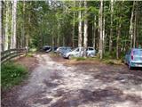
| klm4. 08. 2012 |
Everything is visible in the first picture: at the end of the valley there are no arranged parking lots, only so-called wild parking spots, enough for about 30 cars
|
|
|
|
| karlin19. 08. 2013 |
Yesterday walked the mentioned path - very nice, scenic, not too difficult. On the entire path there are two slightly loosened pitons, otherwise the path is well maintained - praise to the markacists!
|
|
|
|
| mukl11. 09. 2013 |
If the pictures and description hold true, then Tominškova from Vrata (which I've already done) is a minor trifle compared to Lojze Rekar's path to Visoka Vrbanova špica, is that right or am I mistaken?
|
|
|
|
| tinky11. 09. 2013 |
mate, you're not mistaken, but no panic, it's well protected, varied and full of wonderful views.
|
|
|
|
| acjom17. 07. 2014 |
Are there any other peculiarities on the path ... snow?
|
|
|
|
| gasperv21. 07. 2014 |
We walked the tour on Saturday. Up to Debeli kamen there is still some snow - not all can be bypassed, but it's not problematic.
Then the path over Spodnja špica is entirely snow-free. In the initial - grassy part it is somewhat damaged by winter in places.
From Visoka špica we then descended to Stanič's hut and further to Kot. From the hut quite a few snowfields await you, which cannot be bypassed.
|
|
|
|
| ms_primoz21. 07. 2014 |
gasperv - but no snowfield is worth mentioning regarding the danger of slipping. So, cheerfully on the way. I was at "Stanič" from Kot...Good luck and safe step
|
|
|
|
| gasperv21. 07. 2014 |
primož - they asked about conditions and I described them.
The mentioned snowfields probably everyone who is at least a little accustomed passes without problems and without an ice axe. However, you cannot claim that they are negligible and that there is no danger of slipping.
Good luck.
|
|
|
|
| ms_primoz21. 07. 2014 |
gasperv - I'm not accusing you of anything. I just supplemented you. Even if you slip, you stop after max. 2m (without effort). Anyway, that's how I saw the mentioned snowfields. Mentioning ice axe and crampons is even ridiculous. Good luck.
|
|
|
|
| zlatica4. 08. 2014 |
Has anyone hiked this path in the last days? Are there any peculiarities regarding snow, triggered rocks or damaged protections worth noting? My colleague and I are heading up there for the weekend. And how about the snowfields in the Pekel area below Stančičeva koča regarding the return to Kot? Thanks for info.
|
|
|
|
| planika8215. 08. 2014 |
Zlatica didn't get a reply, but I assume based on previous comments that everything is fine on the path (fixed protections, snow..)?
Thanks, best regards.
|
|
|
|
| Keko15. 08. 2014 |
Snow on this path is no longer an obstacle. The fixed protections are in good condition except for one pulled-out peg, which doesn't significantly increase the difficulty in that section.
|
|
|
|
| VanSims15. 08. 2014 |
I confirm regarding snow on the via ferrata itself: there is none!
There is however a small earth slide in the first part on the ascent to the first spire, which in dry conditions is not problematic, but in wet it can cause problems. Since it has rained lately, caution for those going up this weekend!
Snow from Staniča to Kot was already nicely passable three weeks ago with poles and a bit of caution, now it might be even better for some! 
|
|
|
|
| planika8216. 08. 2014 |
Based on the comments I see that wet ground makes this path tricky in places. Given the current conditions (lots of rain), will tomorrow's otherwise sunny day still be recommendable for visiting both spires? I haven't done this path yet, so I'm asking those with more experience on it.
Thanks.
|
|
|
|
| ben16. 08. 2014 |
The path itself through the Vrbanove spires is not problematic due to wet ground, the lower part below the spring and a bit above it is usually quite annoying due to wet ground. But it's nothing that would stop someone from going there , just a bit of caution.
Best, B
|
|
|
|
| tinky16. 08. 2014 |
Went with Todi on Sunday. planika82 check current conditions, Julian Alps, page 3, Vrbanove spires. best regards.
|
|
|
|
| andrejp30. 10. 2014 |
today up there... nice but quite demanding... up to the junction for Vrbanova you have to be careful among the scree because slippery rock, from the junction on the south side is basically dry - north covered with snow and ice but ice axe has nowhere to stick, crampons for 10m up then down again.... fixed protections ok... up and down same path....
enjoyable
|
|
|
|
| malimiha22. 05. 2015 |
I'm interested if we can descend directly from the top to the Stanica hut, how long does the descent take and what is this path like? thanks and best regards,
|
|
|
|
| jedriličar22. 05. 2015 |
Directly to Stanica is half an hour, descent over grassy slopes and some rocks, but a walk ...
|
|
|
|
| pohodnica116. 07. 2016 |
Hello,
has anyone hiked this trail recently, what are the conditions?
|
|
|
|
| slaven7. 08. 2016 |
We were there yesterday, conditions are super, no trace of snow, the path is excellently laid out and secured. Lojze Rekar path is fantastic, I would compare it to Dolgi Hrbet. I sincerely recommend it to everyone
|
|
|
|
| A.D.K.25. 09. 2016 |
Yesterday from Kot up. Very nice path if I subtract the slippery part through the bushes, which is especially annoying on the way down. Otherwise the path is quite steep and exposed in places but great for those who like a bit of "air" under their feet. 
|
|
|
|
| mesargio5. 07. 2018 |
Hi, does anyone have any data on current conditions on this path snow etc? thanks
|
|
|
|
| Tejko9. 07. 2018 |
We were there yesterday. There is still quite a bit of snow in some places, but not on the more demanding sections that are secured with cables. It's only on the hiking part before the cables start and on the path past Staničeva hut, which we took on the way back. We didn't have winter gear and didn't miss it.
|
|
|
|
| PlaRinka19. 07. 2018 |
Today walked this path - only one small snowfield a few steps long remains, otherwise the path is completely dry.
|
|
|
|
| darinka422. 09. 2018 |
Yesterday 21.9. I did Vrbanove špice from Kot. Wonderful path especially yesterday in nice weather. I was first. It worked out well for me, so I was at the car at 19. The road to Dolina Kot is also in good condition.
|
|
|
|
| tijana19. 07. 2019 |
Does anyone know the current conditions on this path? I'm particularly interested in snow and whether winter gear is needed. Thanks!
|
|
|
|
| tijana19. 07. 2019 |
Does anyone know the current conditions on this path? I'm particularly interested in whether there is still any snow field and if winter gear is needed. Thanks!
|
|
|
|
| miranm19. 07. 2019 |
Under "current conditions" you have a description from garmont a couple of days ago, good luck.
We're heading out on this path tomorrow morning.
|
|
|
|
| garmont19. 07. 2019 |
No snow on this trail anywhere anymore.
|
|
|
|
| bo_zl10. 08. 2019 |
Great path, even though I'm not a big fan of climbing let alone via ferrata. Secured everywhere it needs to be. Only the lower part before Dolina Kot is slippery as always, requires quite some caution on descent.
|
|
|
|
| cajer28. 06. 2020 |
Path passable as of today (2 snowfields from cca. 1800 m on, passable due to southern snow).
Vrbanove without issues, dry. Excellently secured, poetry for lovers of such paths.
Return past Staničev dom possible, but still need to cross 5+ snowfields.
|
|
|
|
| squirrel12. 08. 2020 |
Path hiked 9.8.2020. Protections in good condition, but advise checking the bolts as 3 are a bit wobbly. Otherwise these bolts not on critical spots, but caution not superfluous. Initial climbing section and some parts in between not protected by cables, but they are present at most difficult spots. Slightly more demanding is the overhanging descent, there an extra cable would be good for better feeling. Need to be careful choosing holds too, as sometimes a rock stays in hand, terrain very crumbly. Path nevertheless extremely beautiful, but need to be cautious. Helmet mandatory, via ferrata set also useful. One more thing: please don't shout in the mountains, as you scare animals and annoy other hikers. Good opportunity to observe ibex on the path, but only possible in silence and respectful attitude to their environment. While we were ascending, a group ahead was constantly aimlessly yelling (some yodeling, shouting and imitating animals) which of course drove them away.
|
|
|
|
| squirrel12. 08. 2020 |
P.S. the trail is wonderful, very scenic and interesting, 5 hours fly by.
|
|
|
|
| MPS16. 10. 2020 |
Hi. Not entirely up to date, but still might be useful for someone to get a better idea of the path for next year. Short video from the hike from Dolina Kot over Vrbanove špice to Cmir.
Watch the video at the link: Over Vrbanove špice (Lojze Rekar path) to Cmir, 5.9.2020
Good luck, Mirko
|
|
|
|
| pvanina17. 07. 2024 06:01:11 |
Current condition of the path with several damaged protections and a landslide before entering the ridge, which is just waiting to "go" into the valley, perhaps calls for temporary closure. It won't cause problems for those skilled in scree walking and classic vias ferratas, but I advise against it for those expecting shiny cables from the junction to Stanič. This path was never undemanding, and currently, one has to bypass pulling on brackets, pegs, and cables several times.
|
|
|
|
| SaMoMe29. 07. 2024 20:56:37 |
Hiked the path on 26.7.24. At the entry to the wall and a bit below the summit of Spodnja Vrbanova špica, there is a damaged belay (pulled-out bolt with cable), otherwise, in my opinion, the path is well secured where it should be. I think it's better to hike it from Kot towards Stanic due to crumbly terrain. However, I wouldn't recommend it to those who don't like more airy and ridge paths with dizzying views into the valley.
|
|
|
|
| VelikiZajetnež19. 07. 2025 17:13:11 |
Yesterday hammered the uprooted pegs anew
|
|
|
|
| Jernej96811. 08. 2025 08:21:56 |
Two days ago I walked this path. I can confirm that everything on the path is in perfect order.
|
|
|
To post a comment you must log in:
If you do not yet have a username, you must first
register.