Dolina Kot - Spodnja Vrbanova špica (via Lojze Rekar)
Starting point: Dolina Kot (950 m)
| Latitude/Longitude: | 46,4157°N 13,8977°E |
| |
Route name: via Lojze Rekar
Walking time: 4 h
Difficulty: very difficult marked way
Elevation gain: 1349 m
Elevation difference along the route: 1350 m
Map: Triglav 1 : 25.000
Recommended equipment (summer): helmet, self belay set
Recommended equipment (winter): helmet, self belay set, ice axe, crampons
Views: 23.342
 | 5 people like this post |
Access to starting point:
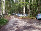
We drive to Mojstrana, then follow the signs for the Kot and Krma valleys. At Kosmačev preval we leave the road that leads further towards Krma, Radovna and Bled and continue driving right onto the side road in the direction of the Kot Valley. This is followed by driving on a macadam road, which we follow to the mountain directional signs at the end of the drivable road in Lengarjev rovtu.
Route description:
From the end of the road we continue along the wider marked path in the direction of Stanič's hut and Kredarica, which ascends gently through the forest. After a few minutes we arrive at the gravel bed of Kotarica, across which we go transversely to the other side, where the path reappears.
This is followed by some easy walking through the forest, after approximately half an hour of walking the path quickly becomes quite steep and due to often quite slippery ground also dangerous for slipping, especially on the descent, so extra caution is required on this section. On this part, a few pitons help us on the more difficult places. Higher up the steepness eases and the path leads us to the spring Pri studenčku, which however dries up in dry periods.
Here an unmarked path branches off to the left towards Macesnovec, but we continue straight across the torrent, and after the torrent we cross a short secured but not particularly difficult section. This is followed by an ascent through a belt of dwarf pines, higher up we arrive in an increasingly rocky world, where we can already nicely see a larger boulder in front of us. Here our path is crossed quite inconspicuously by the PP path (Planica - Pokljuka path), but we ascend with ever better views to the previously mentioned boulder called Debeli kamen.
At Debeli kamen the dwarf pines occasionally end completely and we continue through an increasingly high-mountain world, where we mostly ascend on scree. On this section, looking back, a nice view of Ladja opens up (Ladja is a prominent precipitous promontory or peak overgrown with dwarf pines that rises above the Kot Valley), and then we ascend to the marked junction, where a climbing path to the Vrbanove špice branches off to the right, or the Lojze Rekar path.
We continue in the mentioned direction (left to Dom Valentina Staniča and Rjavina) and after just a few meters the path turns right again, where with the help of a few steel cables and pitons we cross steep rock slopes below the Vrbanove špice. Then we turn left and in a slight ascent we cross still quite steep slopes. Shortly after that we turn left again and with the help of some protection we start to climb steeply up the slope partially overgrown with grass and dwarf pines. The path then turns slightly right and leads us to the ridge, where a view of Cmir opens up. Here we turn left and with the help of pitons and steel cables we start ascending the steep and narrow ridge, which soon leads us to a junction. From the junction we head left (slightly right continues the path towards Visoka Vrbanova špica) and with the help of some pitons and bolts we reach the summit of Spodnja Vrbanova Špica. The summit also has a stamp and a summit register.
Starting point - Pri studencu 1:25, Pri studencu - Debeli kamen 1:20, Debeli kamen - turnoff for Vrbanove špice 0:30, Turnoff for Vrbanove špice - Spodnja Vrbanova špica 0:45.

Along the route: Pri studencu (1330m), Debeli kamen (1810m), Odcep za Vrbanove špice (2005m), Odcep na Spodnjo Vrbanovo špico (2279m)
Photos:
 1
1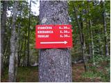 2
2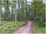 3
3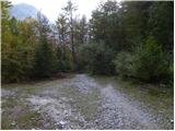 4
4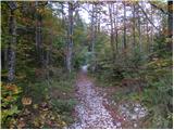 5
5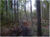 6
6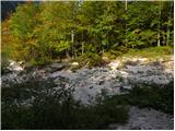 7
7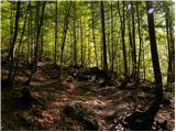 8
8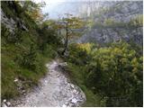 9
9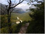 10
10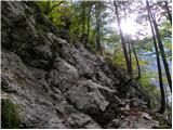 11
11 12
12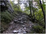 13
13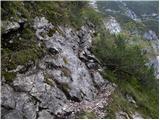 14
14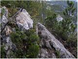 15
15 16
16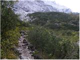 17
17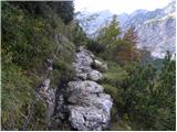 18
18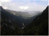 19
19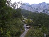 20
20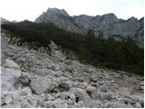 21
21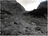 22
22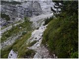 23
23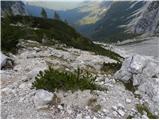 24
24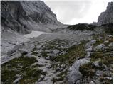 25
25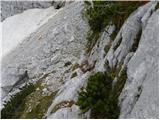 26
26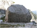 27
27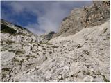 28
28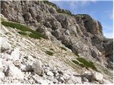 29
29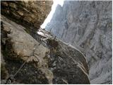 30
30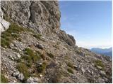 31
31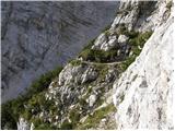 32
32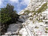 33
33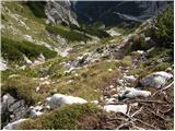 34
34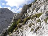 35
35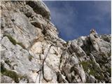 36
36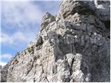 37
37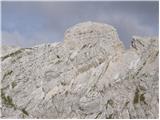 38
38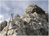 39
39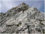 40
40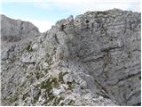 41
41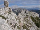 42
42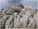 43
43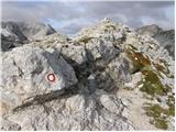 44
44
Discussion about the trip Dolina Kot - Spodnja Vrbanova špica (via Lojze Rekar)
|
| velkavrh1. 08. 2009 |
For two years I've been watching it, as it looks from Kot when passing by, an inaccessible mountain. But there is a path for the brave, lovers of cables and mountain solitude. Today I conquered it. I started from the parking lot in Kot already at half past five and there was no heat. There are not many cables to the top, so it is easier than the neighboring Rjavina. But if we add the continuation to Vrbanov vrh above Staničev dom, we can really say they are somewhat equal in difficulty. In Staničev dom they assured that they will replace the full logbook with a new one. Praise!
|
|
|
|
| velkavrh28. 05. 2011 |
Just as I'm considering it as a tour suggestion, I remember that two years ago I didn't have the booklet with me for these peaks around Staničeva. When I came around again last year with the stamp of the last one - Cmira, there weren't enough stamps in my booklet to get the gift for all conquered peaks. I'll try to repeat Vrbanove špice this year too, so I finally get those coveted socks as a reward-ha,ha!
|
|
|
|
| Bizy28. 05. 2011 |
What booklet and reward are you talking about? Can you tell a bit more, I'm really interested in more about this matter.
|
|
|
|
| klm29. 05. 2011 |
PD Javornik-Koroška Bela; i.e. the manager of Dom Valentina Staniča also has an "action" in which the main prize is hiking socks. For that they issued a special booklet with empty squares, into which you stamp stamps from the surrounding peaks. To acquire the socks as a prize, you have to climb all the surrounding peaks - Rjavina, Vrbanove špice, Cmir and Begunjski vrh and stamp their stamps in the booklet.
|
|
|
|
| Bizy30. 05. 2011 |
@klm thanks really for the info.
Interesting thing, I'm excited and immediately in. So definitely in summer an attack on the peaks follows, to get the socks! 
|
|
|
|
| velkavrh31. 05. 2011 |
Yes, I've been conquering them like this for a couple of years, Rjavina for example I conquered twice. First time I was already at the top at the junction where you go towards Staničevi or to the top but I had to continue towards Staničevi because it was too foggy. On Cmir I was also a couple of years earlier, even from Pokljuka, but it didn't count. So this year I'm really repeating only Vrbanove špice. Vrbanove špice from Kota are quite demanding. There are plenty of steel cables.
|
|
|
|
| Okmodko12. 11. 2011 |
Does anyone know if there's still snow up there? Is it possible to get up there without danger?
|
|
|
|
| iztok.maltar12. 11. 2011 |
Depends what counts as dangerous. Today in Kot higher up the ground is quite frozen, but since the path runs from Debeleg kamen on the SE side, the wall and ground will probably still thaw in the sun.
|
|
|
|
| Okmodko13. 11. 2011 |
Eh, I'm going somewhere else 
|
|
|
|
| goginho211. 04. 2013 |
From what I read above, I conclude that the climbing paths to Spodnja Vrbanova špica and to Rjavina are well secured. Yay I'm already looking forward to them.
|
|
|
|
| Tinca512. 04. 2013 |
Quite justified
|
|
|
|
| journeyman6. 07. 2013 |
Lp
I'm wondering if anyone knows what the snow conditions on the path are like?
thanks
|
|
|
|
| steyr9. 07. 2013 |
Has anyone walked this trail these days? Is there possibly still some snow patch somewhere? regards
|
|
|
|
| idesh10. 07. 2013 |
We went on Sunday along this path to Stanič's hut and winter gear is not needed. From Stanič's to the valley there are a couple of snow patches but everything is passable.
Nice tour
regards
|
|
|
|
| cvetlica8920. 08. 2013 |
Excellent tour. For lovers of lojtrics, pitons and belays, the ridge between Spodnja and Visoka Vrbanova špica is pure pleasure Snack on Plesišču, which is currently full of gentians, is pure paradise anyway In short, excellent escape into solitude before the motorway to Staničeva.
|
|
|
|
| katja879. 09. 2013 |
On Sunday 8.9.2013 we did this extremely interesting climbing path.
We did the tour: Kot - dom Valentina Staniča - Visoka Vrbanova špica - Spodnja Vrbanova špica - Kot.
When we arrived at Stanič's hut, we already thought we wouldn't be able to conquer any summit, as the wind gusts were extremely strong and therefore dangerous for the ridge path, of which there are plenty on the Vrbanove špice. However, after an hour of rest in the hut, it finally eased a bit, so we decided for this path anyway and in the end we didn't regret it, as it is really something unique 
The climbing path of Lojze Rekar itself is very demanding and quite exposed. There are many narrow intermediate ridges, so it can cause problems for those with fear of heights.
You can see pictures from the hike on the website of the Matica Murska Sobota Mountaineering Association: http://www.mojalbum.com/pdmaticams/20130908-vrbanove-spice-pot-lojzeta-rekarja/pot-iz-doline-kot/21074804
|
|
|
|
| tvodop20. 07. 2016 |
From the direction of Koča V. Staniča to Spodnja Vrbanova špica the path is really top-notch - pure climbing pleasure. All hiking paths to Triglav pale in comparison. Most of the terrain is very crumbly, handholds even pull out. The descent is very dangerous as it is crumbly and requires great caution.
Recommended for really experienced mountaineers.
|
|
|
|
| BT8820. 07. 2016 |
The path needs to be done in the reverse direction .And don't scare people .And don't scare people
|
|
|
|
| tvodop20. 07. 2016 |
BT99, I don't know why in the reverse? Because it's easier?
|
|
|
|
| jax20. 07. 2016 |
No, the description of difficulties might really be somewhat exaggerated, but the difficulty assessment is always subjective. That it's easier in the reverse direction, of course holds true.
|
|
|
|
| S220. 07. 2016 |
It holds that the direction from Spodnje Vrbanove špice towards Visoke Vrbanove špice and Staničeva koča is really easier. However, the direction is feasible also in reverse from Staničeva koča and is more demanding. For both directions caution and experience apply.
|
|
|
To post a comment you must log in:
If you do not yet have a username, you must first
register.