Starting point: Dolina Kot (950 m)
| Latitude/Longitude: | 46,4157°N 13,8977°E |
| |
Walking time: 3 h 30 min
Difficulty: difficult unmarked way
Elevation gain: 976 m
Elevation difference along the route: 980 m
Map: TNP 1:50.000
Recommended equipment (summer):
Recommended equipment (winter): ice axe, crampons
Views: 49.095
 | 2 people like this post |
Access to starting point:
From Mojstrana we drive along the road that leads to Radovna, before the road starts descending towards Radovna and Krma, we turn right onto the turn-off of the forest road into Kot Valley (marked with a signpost). Along the narrow, well-maintained forest road we drive to the parking lot on Lengarjev Rovt.
Route description:
From the parking lot we first walk for quite some time along the marked path that leads to Staničeva koča mountain hut. The path is in places slightly exposed, at the most exposed spots secured with a few pegs and two steel cables.
When we come to the small spring that we spot on the left side beside the path (a short section of a gutter is placed there so that we can fill our water bottles, next to it on a smaller rock the inscription "drži čistočo"), we should pay attention: about 50 m ahead, an unmarked path branches off to the left upwards from the marked path, namely just before the marked path turns right across the torrent gully.
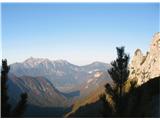
The unmarked but well-visible trail climbs quite steeply towards the large scree slope, soon splitting into two - right (upper) and left (lower). Both trails join again higher up. The lower (left) one ascends quite evenly across the scree and among the dwarf pines (often marked with cairns), the upper (right) one first climbs quite steeply across the scree, then leads in a gentle ascent without major pronounced steep sections to the point where both paths join again. From there the path continues mostly very steeply up the slope, in a sparse larch forest and dwarf pines, exposed in quite a few places (slip hazard), but easy to follow throughout. A little below the summit the path crosses the ridge to the other side (until then we were on the slope above Kot, from there on the slope above Krma). Just below the summit the dwarf pines entirely replace the previously dominant larches. The summit itself is rocky and covered in grass.

Photos:
 1
1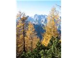 2
2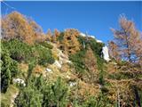 3
3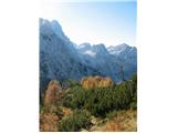 4
4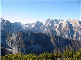 5
5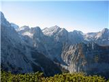 6
6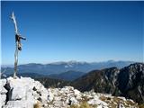 7
7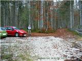 8
8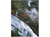 9
9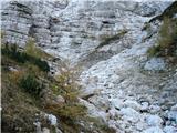 10
10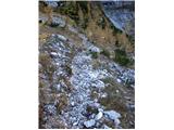 11
11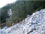 12
12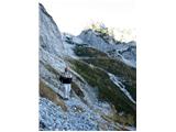 13
13
Discussion about the trip Dolina Kot - Macesnovec
|
| Gost2. 11. 2007 |
We climbed to Macesnovec today 2.11.07. Wonderful weather. The path is slightly snowy in the upper part but still very good. Larches are almost bare.
Vida and Franc K.
|
|
|
|
| Domch22. 10. 2012 |
I was up there on Saturday. A true autumn idyll in the heart of the Julian Alps. The path is quite awkward, especially for descent. The mountain is undoubtedly worth a visit, as it offers really nice all-around views. At the top, sunbathing topless and admiring the snow-covered peaks. A spring with water along the path delighted me too.
|
|
|
|
| strelec195423. 09. 2013 |
Macesnovec, another among the more solitary peaks, from which the view of the surrounding peaks is simply wonderful. Perhaps that's why the path is not marked but it's not hard to spot as it's well visible, soon after the spring of drinking water on the way to Stanicheva koča.
Conditions on the path are currently good. The larch forest is still clad in green but the first signs of golden yellow autumn are already showing, which will give this loner an extra charm.
|
|
|
|
| dprapr21. 06. 2014 |
Today's 3.5 hours walking has quite a margin, 3 hours would be enough (moderate pace).
|
|
|
|
| Pastirica18. 10. 2014 |
I agree, 3 hours is enough (and I'm far from the youngest), since we only cover less than 1000 m elevation gain. The elevation data on the path is wrong, because we don't lose height anywhere.
Today the summit was massively visited, views sparingly enjoyed, the path itself, except in the middle section, wet and slippery and required full caution.
|
|
|
|
| dj1225. 12. 2015 |
Has anyone been here these days? And what are the conditions like. Regards
|
|
|
|
| dino16. 08. 2017 |
Beautiful shady path for hot summer days, no "stampede", ideal for aerobic meditation!
|
|
|
|
| tango30. 08. 2017 |
Today was an ideal day for the visit. Wonderful views and no one anywhere. Highly recommend!
|
|
|
|
| skala12329. 07. 2018 |
Nice hike today to Macesnovec, no hikers except us two. The elevation gain on the trail isn't accurate, because on the trail we don't go up and down but steadily up and it doesn't exceed 1000 m elevation gain on the trail. Nice tour.
|
|
|
|
| Tadej29. 07. 2018 |
Thanks for the notice. I've corrected it.
|
|
|
|
| damijanp22. 10. 2018 |
On Saturday, Macesnovec more than lived up to its reputation - the larches were glowing in their most beautiful autumn display.
Some photos are on the link:
Macesnovec
|
|
|
|
| Jusk20. 09. 2019 |
Wonderful view from the top of this more solitary mountain worth the effort on the steep and partly exposed path for such a view in all directions I started the path already at Kosmačev pass, so I walked the whole Kot
|
|
|
|
| SunChine8. 10. 2019 |
Hello, I'm interested in the current condition of the forest road into Dolina Kot? Thanks for the reply
|
|
|
|
| Stane78. 10. 2019 |
The road is completely fine, on Saturday there were quite a few cars in Lengarjev rov.
|
|
|
|
| cajer11. 10. 2019 |
Hi, if anyone has been to Macesnovec in the last days and would be willing to share the state of the larch color, I would be very grateful. Thanks in advance!
|
|
|
|
| ljubitelj gora11. 10. 2019 |
End of the month they'll be, they've just started, visible today above Pokljuka.
|
|
|
|
| SunChine13. 10. 2019 |
Was there today, larches at Macesnovec are already turning yellow.
|
|
|
|
| Spelalucka17. 10. 2019 |
Hi,
I'm wondering if the path is suitable for a visit with a dog?
Thanks in advance!
|
|
|
|
| Jusk17. 10. 2019 |
I would say it's not really suitable for dogs. In places the path is quite narrow and steep, also slippery. Better not.. Lp
|
|
|
|
| ljubitelj gora17. 10. 2019 |
Yes really the larches have advanced a lot, above 1600-1700m they glow.
|
|
|
|
| tango8. 11. 2020 |
My wife and I were tempted by the descriptions of the approach along the ridge between Krma and Kot, but we ended our tour at Trta, as the ascent to Macesnovec via Luknja was too much. Otherwise, the terrain up to Biščikova glava is steeply upright, and it was a real relief when we reached the caves, which meant we were on the right approach. Continuation to Trta bp, return to Zg. Krma via the gully, not directly from the top, where the return due to fallen trees from 2014 and additionally those felled by this year's early snow was quite an adventure. But nice, the description by the Dovška parish priest is really useful!
|
|
|
|
| plaNinaPirsMajcen13. 10. 2025 17:19:14 |
Hi, the trail to Macesnovec is really the most beautiful during the golden larch glowing time.
Attaching video of our experience:
https://youtu.be/lvai9dPU8m0?si=AT4EodpO3dQfb_Mp
At the left junction a bit after the water fountain you really need to pay attention, as the path is not immediately well visible. Further on it's followable, but due to scree and steepness a bit strenuous. However, the whole area, including the larch forest in the upper part, is mostly in shade this time of year and thus consequently damp. Caution is needed at almost every step.
The summit is so beautiful and panoramic that one can hardly say goodbye.
Best, Nina
|
|
|
|
| felix15. 10. 2025 07:38:02 |
|
|
|
|
| julya15. 10. 2025 20:26:27 |
|
|
|
To post a comment you must log in:
If you do not yet have a username, you must first
register.