Suhadolnik - Grintovec (via Streha)
Starting point: Suhadolnik (901 m)
| Latitude/Longitude: | 46,3352°N 14,5102°E |
| |
Route name: via Streha
Walking time: 4 h 45 min
Difficulty: difficult marked way
Elevation gain: 1657 m
Elevation difference along the route: 1700 m
Map: Kamniške in Savinjske Alpe 1:50.000
Recommended equipment (summer):
Recommended equipment (winter): ice axe, crampons
Views: 173.140
 | 9 people like this post |
Access to starting point:
From the Ljubljana - Jesenice highway, we take the Kranj - East exit and follow the road ahead towards Jezersko, but only to the village of Kokra. In the mentioned village, a few meters before the road crosses the bridge over the Kokra River, we will notice a road that leads towards Suhadolnik. The road turn-off is located when we are on the right side of the river (left bank); the road sign is approximately 7 km. We then follow this road to the parking lot, which is located approximately 300 meters before the farm Suhadolnik.
Route description:
At the beginning of the parking lot, we notice hiking signposts, which direct us to a road, along which in less than 5 minutes of walking we arrive at a smaller crossroad by the farm Suhadolnik. Here we continue on the right road, which we follow for approximately 5 minutes, or to the spot where the blazes lead us onto an ascending cart track. Further, for a short time we ascend the cart track, then the blazes direct us right onto a footpath, which moderately ascends through the forest. Higher, we return to the cart track, which only a few meters further brings us to a forest road, which we then follow to its end (to here we need approximately half an hour).
At the end of the road, the marked path splits into two parts. We continue on the left path (right somewhat easier "Old path"), which further ascends on a gentle cart track. Somewhat further, the blazes direct us slightly right onto torrent deposits of sand, and the path on the other side continues through the forest, where it begins to ascend ever steeper. Higher, we come to a smaller cavity, and the path behind it becomes technically demanding. With the help of a steel cable, we ascend one level higher, and the path then continues on a steep slope, where occasionally some peg helps us. Higher, the path turns right, ascends transversely over steep and especially in wet slippery-dangerous slopes, and then brings us to an excellently secured passage. With the help of wooden steps or ladder and help of a steel cable, we ascend the steep slope, which without the mentioned safety devices would be very dangerous. Higher, a few more pegs help us, the path then flattens and crosses a short exposed slope, where an emergency fence helps us. Only a little further we come to the next ladder, next to which there is no steel cable, but the passage is not particularly demanding. Follows a short descent into a smaller gully, which we then cross. On the other side of the gully, we ascend steeply (some pegs help us), then the path gradually flattens and in a few dozen steps of further walking brings us to the spot where the somewhat easier "Old path" joins.
Follows a short transverse ascent and the path brings us to a larger plain, where the "old hut" once stood. Through high grass we walk to the other side of the plain, where we arrive at a marked junction.
We continue straight (left Kočna over Grdi graben) on a moderately steep path, which further ascends through a belt of bushes. Higher, the path temporarily completely flattens, then brings us among dwarf pines, where it begins to ascend more steeply. This somewhat steeper path, from which increasingly beautiful views open, we follow all the way to the Cojzova koča on Kokrsko sedlo.
From the saddle, we continue left in the direction of Grintovec, Kočna, and Skuta. The path immediately above the saddle steeply ascends and somewhat higher brings us to a junction, where to the right branches the path to the bivouac under Grintovec and Skuta. We continue straight on the "main" path, which flattens and turns somewhat left, where it crosses the slopes of the indistinct valley named Jame. The path then ascends in a traverse to the summit slope of Grintovec - Streha (this part is in winter very dangerous for slipping), where we come to the next junction. We continue right (left Kočna) on the path, which ascends on the summit slope of Grintovec relatively steeply upward. Initially still grassy slope is quickly replaced by scree, which then accompanies us on the path. The increasingly scenic path, from which increasingly beautiful views open, then quickly brings us to the summit of Grintovec.
In winter, the path is exposed to avalanches, and there is also a great risk of slipping.
Suhadolnik - Kokrsko sedlo 2:30, Kokrsko sedlo - Grintovec 2:15.

Photos:
 1
1 2
2 3
3 4
4 5
5 6
6 7
7 8
8 9
9 10
10 11
11 12
12 13
13 14
14 15
15 16
16 17
17 18
18 19
19 20
20 21
21 22
22 23
23 24
24 25
25 26
26 27
27 28
28 29
29 30
30 31
31 32
32 33
33 34
34 35
35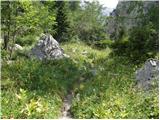 36
36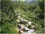 37
37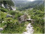 38
38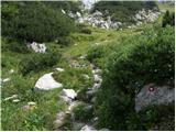 39
39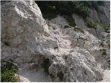 40
40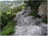 41
41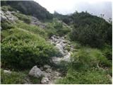 42
42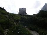 43
43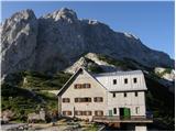 44
44 45
45 46
46 47
47 48
48 49
49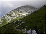 50
50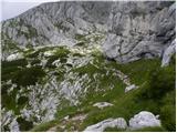 51
51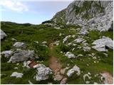 52
52 53
53 54
54 55
55 56
56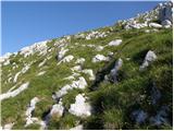 57
57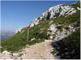 58
58 59
59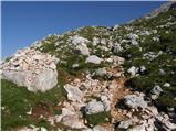 60
60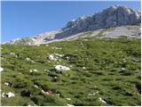 61
61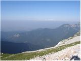 62
62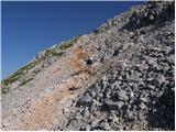 63
63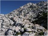 64
64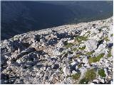 65
65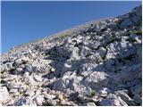 66
66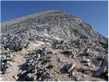 67
67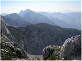 68
68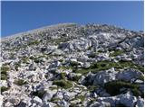 69
69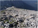 70
70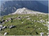 71
71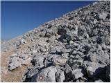 72
72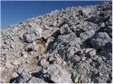 73
73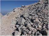 74
74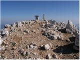 75
75 76
76
Discussion about the trip Suhadolnik - Grintovec (via Streha)
Show older messages
|
| saso.alpinist27. 08. 2008 |
This path is really excellent. Not demanding but you still need some fitness because it's quite long. My friend and I went to Grintovec yesterday via this path and it took about 1h 50min to Cojzov dom and another 2 hours to the top but we took lots of photos along the way and could have gotten up earlier. The jota at Cojzov dom on the descent from Grintovec hits the spot best. But the path from Kokrško sedlo to Kamniška Bistrica is quite nasty due to the terrain you walk on... and your legs hurt quite a bit afterwards 
But... nice hike and an even nicer mountain.
|
|
|
|
| saso.alpinist27. 08. 2008 |
Well yeah... sure we're still young (we're 15 years old) but this tour isn't exactly dangerous. Soon we'll also go to Ojstrica and later in September with the mountaineering club to Sonnblick (3106m)... which will be our personal altitude record.
Our life goal is to become alpinists and reach the summit of Mont Blanc at 18.
Most people think it's crazy but that's just how we are... in love with mountains and nature... whatever
|
|
|
|
| velkavrh26. 07. 2009 |
Today there was a mountain run on Grintavec. They started from the hut in Kamniška Bistrica up to the top of Grintavec. The winner clocked 1 hour and 19 minutes, which is just four minutes off the record. There were three hundred registered competitors. Spectators were huge along the entire route from Cojzova koča to Grintavec. And the weather was nice too. And I was there with my buddy Dušan cheering at the top of Grintavec. I've never been at such an event before - really something extraordinary.
|
|
|
|
| Hribec14. 08. 2009 |
How drivable is the road to Suhadolnik?
If the road is maybe as bad as to Valvazorjeva koča, it's a bit of a shame for a car with lowered suspension.
|
|
|
|
| barjus14. 08. 2009 |
The road to Suhadolnik is quite normal. Here and there a pothole due to water but no great caution needed to pass by. You can get up without issues with any car. Was there two days ago.
|
|
|
|
| jacoby654. 11. 2010 |
Does anyone perhaps know the condition of the road to Suhadolnik. On Saturday I plan to go to Grintovec after all.
|
|
|
|
| serajko5. 11. 2010 |
Yesterday it was normally passable
|
|
|
|
| nata2429. 01. 2011 |
Does anyone know how the road to Suhadolnik is, or better to go from Kam. Bistrica?
|
|
|
|
| pelican29. 01. 2011 |
To Suhadolnik I think with good winter tires shouldn't be a problem. Snow just enough to be white, on sunny spots it's already gone.
|
|
|
|
| gornica22. 06. 2011 |
Hello all mountain lovers! I'm wondering if anyone went to Grintovec from Suhadolnik over Streha recently. What's the path like? We intend to go up this path on Sunday. Thanks for all the useful information.
|
|
|
|
| Damien_8322. 06. 2011 |
The trail is completely dry, well secured..except the first ladder is already a bit "worn" (needs minor repair) but passable, otherwise no major issues Regards
|
|
|
|
| tomko22. 06. 2011 |
Today I was on Grintovec and the trail is completely normally passable as Damien 83 already mentioned. Only the ladder is damaged, the last one if going up over Taško and one peg a bit further. The first one when returning?!?
|
|
|
|
| Damien_8322. 06. 2011 |
I was wrong, it's the second one... sorry
|
|
|
|
| gornica23. 06. 2011 |
Damien and tomko thanks for useful info. So if weather nice, Grintovec conquered! Regards
|
|
|
|
| hund-titan23. 06. 2011 |
Is it possible to reach Grintavec with a dog? In the picture I see there are also ladders on the path, which is the biggest obstacle that my dog can still handle without problems. Could I expect anything more difficult? Thanks to whoever takes the trouble to provide information.
|
|
|
|
| velkavrh23. 06. 2011 |
From Suhadolnik, the easiest way to Cojzovo is along the old path, the one via Taška is harder-there you have ladders. So along the old one without problems. From Cojzovo to Grintavec along the usual via the so-called path through Streho. It's well marked-you can't get lost. Shortly above the hut there's a junction for Skuto-that path goes left, another twenty minutes or so and another left turn to Ovnov čer to Spodnje Dolce to the bivouac under Kočna and onwards to Kočni. For the dog, the only slightly unpleasant part is the quite rocky path about half an hour before the summit. For this path you need about five hours one way from Suhadolnik at moderate pace. I wish both of you much enjoyment-and of course water for your friend! Best regards.
|
|
|
|
| velkavrh23. 06. 2011 |
Correction - the turn to Skuto goes right, our path to Grintavec is left.
|
|
|
|
| GregorC11. 08. 2011 |
On Saturday I'm a bit drawn up there, and I'm interested in what condition the road to Suhadolnik is in? LP
|
|
|
|
| ZionExpress11. 08. 2011 |
Today I was at the top, phenomenal day, only disturbed by Czechs in sneakers. The road to Suhadolnik is normally drivable, of course adjust your speed. In some places it's a bit eroded by water, but you can bypass them without problem.
|
|
|
|
| _sandra_21. 08. 2011 |
Yesterday, 20.8. we were at Grintovec. The road to the parking at Suhadolnik farm is OK, no major potholes, so you can get there without problems. We continued to Cojzova koča on the old path, when you come from the forest among the rocks, markings are visible up to the middle, then not so we got a bit tangled and only from the top of the rocks noticed the next marking that we have to go left  the path to Grintovec still requires some fitness the path to Grintovec still requires some fitness
|
|
|
|
| panda21. 08. 2011 |
I returned on Friday (20.08.) down the old path from the hut towards the parking. I don't know how you could "miss" the direction to the hut. When you come out of the forest follow a short descent into the gully, where you bypass to the left in a semicircle the torrent gully from under Kalški greben. On the left wall there's a big red dot, follow ascent over boulders and left to the path to the junction about 15 minutes (the paths join (old path-easy path and path čez Taško). It's true that orientation downhill is easier, but still?
|
|
|
|
| _sandra_21. 08. 2011 |
we weren't the only ones who "missed it", true we went for the first time, but the mark on the rock to the left is visible only when you pass by or are above it to see it from the higher rock.. it just took us 15 extra minutes, which we didn't worry too much about
|
|
|
|
| Enka28. 08. 2011 |
I agree too that the markings at that gully under Kalški greben are strange. We also started climbing but quickly stopped because I insisted that such climbing can't be marked as an easy path on Hribi.net. And I was right, we then found the passage, and later the marking.
|
|
|
|
| Janiel7417. 09. 2011 |
After yesterday's Mangart, today unplanned on this path, below via Taško Very nice path, quite nice weather, although foggy at the top. Need to take advantage before the snow comes
|
|
|
|
| gaco23. 11. 2011 |
Hi!
I'm planning to go to Grintovec this weekend, and I'm wondering if the conditions are still okay for it, I mean regarding snow. Since I've never been up there.
|
|
|
|
| ananina23. 11. 2011 |
I went up Grintovec via this path on Saturday, 19.11., and there was no snow at all. Good luck!
|
|
|
|
| vito6325. 11. 2011 |
The path to Grintovec is dry and safe. Went up the old path today. Thanks Sandra for your warning, you can really miss the trail there, which thanks to you I didn't-I didn't put my eyes on the stems. Maybe I would have a comment on describing paths to some starting points-e.g., that it would be stated how many km you have to drive from the main road to them. In case of impassability of these roads, this would be welcome information for a hiker going on a certain tour for the first time, as he would know how much additional path he would walk if he decided for that tour anyway and parked the car at the nearest parking spot. In this specific case, from the village Kokra to the parking lot 2600 m-about half an hour walk. From the roundabout at Kranj Mercator to where we leave the main road (before the bridge in Kokra) about 17 km. Otherwise thanks for the otherwise good path description.
|
|
|
|
| gaco27. 11. 2011 |
Snow fell on Grintavec in the evening, nice sunny weather, super overall. Only the last ladder could be replaced as it's quite worn. And at the main road below it could say how many km to the parking, as first time in the dark you're not sure if you're on the right way. But still super tour worth it.
|
|
|
|
| Amanda15. 01. 2012 |
Yesterday my colleague and I set off for the summit. Our starting point was at the Suhadolnik farm. On the path very variable conditions from powder snow, ice in places, to sugary snow that doesn't hold its own weight and slides in pieces under its own weight. Therefore ice axe and crampons mandatory equipment. Yet on the path itself we met people without proper equipment, i.e. no crampons and ice axe. Otherwise polar cold on the top with the help of wind. The tour really for those in good condition. Views magical
|
|
|
|
| robis10. 09. 2012 |
Yesterday I was on Grintovec for the first time and had a pretty good pace relative to the marked time. Suhadolnik-Cojzova koča 1:45, twenty minutes break and to the summit another 1:45. I'm not a mountaineer who regularly tackles such elevation gains so I'm quite proud of my time, especially since I go to the mountains maybe max 10x a year and even then only up to 1500m. Hope that changes. Best regards to all mountain lovers.
|
|
|
|
| jax10. 09. 2012 |
robis:
I'm quite surprised that a whole bunch of commentators haven't appeared here yet with words: you don't race in the mountains, you have to hike with enjoyment, not fast etc.
Anyway, before any such comment appears, let me say something: Bravo! Nice pace (it can be done quite a bit faster, but you probably know that...). Clearly you're capable of much more than you thought until now.
|
|
|
|
| katty23. 10. 2012 |
Such a wonderful autumn day like today just has to be seized . Up through Taško, down the old path. Excellent. Through Taško the cables and of course the chamois liven up the path, the views though... ah, no need to waste words. Up through Streho to the summit, down from Cojzova koča along the old path. We also hiked through the torrent gorge, which is quite nicely interesting. In short, a nice tour, that icing on the cake - the ascent over Mlinarsko sedlo was missing . Up through Taško, down the old path. Excellent. Through Taško the cables and of course the chamois liven up the path, the views though... ah, no need to waste words. Up through Streho to the summit, down from Cojzova koča along the old path. We also hiked through the torrent gorge, which is quite nicely interesting. In short, a nice tour, that icing on the cake - the ascent over Mlinarsko sedlo was missing . Nice trail, so no complaints. . Nice trail, so no complaints.
|
|
|
|
| matic.m24. 10. 2012 |
Hello! I would like to give advice to the moderator regarding the description "Access to the starting point". In the dark, the markers from the road leading to the Suhadolnik farm are very poorly visible. The description also has a somewhat awkward explanation of how to reach the farm (In the mentioned village, a few meters before the road crosses the bridge over the Kokra river, we will notice a road leading towards Suhadolnik. The road junction is located when we are on the right side of the river (left bank), the road sign is about 7 km) - we thought we had to turn right already before the first bridge crossing Kokra. Since there are quite a few bridges crossing Kokra, I recommend changing the path description to the starting point (Suhadolnik) somewhat in this direction. In Kokra village we have to cross the Kokra river three times (3x). Before the fourth crossing of the Kokra river, we turn right onto the gravel road, where we will immediately notice signs directing us towards Suhadolnik. Thanks for understanding. I hope I didn't complicate it too much, but yesterday we found this junction in the dark after several attempts. We focused on the first bridge crossing Kokra and looked for the junction there. Therefore, it seems sensible to change the description.
LP
|
|
|
|
| redbull17. 04. 2013 |
has anyone walked this path to Kokrsko saddle recently or does it sink too much?
lp
|
|
|
|
| Nastasja21. 03. 2015 |
On March 19, crampons were found on the path to Grintovec. If you miss them, contact Marjan Kastelic (Marjan Kastelic-Muša) on FB.
|
|
|
|
| gandalf22. 03. 2015 |
the crampons have already found their owner and are almost on the way to her
|
|
|
|
| esque22. 03. 2015 |
This is proper mountaineering ethics. Respect!
|
|
|
|
| natalia2319. 10. 2015 |
HELLO MOUNTAINEERS, DOES ANYONE KNOW IF IT'S POSSIBLE TO GET A STAMP FOR THE BOOKLET AT THE HUT AND ON THE SUMMIT?
|
|
|
|
| subaru20. 10. 2015 |
One stamp is located at the summit itself (I think it's not under snow yet), the other, if memory serves, in the winter room of the Cojzova hut.
|
|
|
|
| natalia2320. 10. 2015 |
Thanks to Subaru for the help.
|
|
|
|
| seinfeld21. 06. 2017 |
Yesterday my son and I took this path, up via Taško, back on the old path. Personally the path via Taško is easier for me, as it is much better secured with chains and cables. The old path is quite steep with considerable climbing and crumbly. The path to Grintovec summit is technically not difficult, but steep and extremely fitness-demanding, and you have to return too. Those without training will struggle. Memorial plaques along the path remind of this. Otherwise weather was wonderful, windless at top. Path is over 13km long, with stops back at car in seven hours.
|
|
|
|
| seinfeld21. 06. 2017 |
And also; for access to the starting point follow the above advice from matica m. The road is solid, no issue with a van, a lower car I'd pity.
|
|
|
|
| Enka21. 06. 2017 |
On the old path there's only one spot where you need to use hands a couple of times. I agree though that this spot and the section after (down) is unpleasant due to crumbly rock and scree.
|
|
|
|
| jurski27. 12. 2018 |
I don't know about the old path, but when crossing Taško I recommend using a helmet. On the steepest and secured section of the path there is a lot of loose scree that slides down.
Today there was spontaneous rockfall above me, which fortunately flew past me.
|
|
|
|
| janez416. 07. 2019 |
The road to the parking lot at Suhadolnik is normally drivable, in some sections minor caution is needed.
|
|
|
|
| croslo31. 07. 2019 |
On 4.8. we plan to go to Grintovec via the path described by Ljubica Š. Does anyone have new information about the path, is it still impassable.
|
|
|
|
| croslo31. 07. 2019 |
Thank you, thank you, many thanks, Enka.
|
|
|
|
| som693. 08. 2019 |
If you follow the markings, the trail is normally passable. The trail via Taško is currently not used for descent. But the terrain above Suhadolnik has actually completely changed. Lp
|
|
|
|
| šoni28. 10. 2019 |
Enka, you're misleading the Croat, he's asking about the starting point Suhadolnik
|
|
|
|
| mirank28. 10. 2019 |
In three months you've already created a real picture of how it is
|
|
|
|
| Enka28. 10. 2019 |
Šoni, look a bit better before you accuse someone of misleading. Those are heavy words. Croslo was asking about the route on 31.7.2019 and I directed him to the dRM report from 27.7.2019, which starts like this: "Today to Grintovec from Suhadolnik....". Still, I believe croslo had a good time on Grintovec
|
|
|
|
| kozorog949. 06. 2020 |
Hello, I plan a hike to Grintovec (via Streho). How is the path from Suhadolnik - are both the path via Taško and the old path marked? What is the current condition of the path via Taško, is it still damaged and closed? Which one do you recommend?
|
|
|
|
| sla10. 06. 2020 |
The path via Taško is officially closed and there are signs below and above recommending the use of the Old path.
In fact, the path via Taško is quite damaged in the upper part due to a landslide, and in the middle part the log steps are damaged - broken and partly destroyed.
|
|
|
|
| ms_primoz4. 08. 2020 |
The old path (towards Cojzovi koča) is ok and well marked. Through Taško closed, but some people walk on it.
|
|
|
|
| kuzmanb26. 08. 2020 |
The path over Taško is supposed to be repaired now. Can anyone confirm?
|
|
|
|
| blazgrum28. 08. 2020 |
Yesterday I was on Grintovec via Taško and can confirm the path is repaired. On descent I met path markers fixing the first ladder on the ascent. Everything else is already done.
|
|
|
|
| Lenakr16. 06. 2022 09:32:14 |
Has anyone been to Grintovec recently via this path, specifically over Taško? Is it passable?
|
|
|
|
| Spelcarocket16. 06. 2022 15:24:48 |
Was there a week ago, all normal, passable.
Lp
|
|
|
|
| Lenakr17. 06. 2022 07:37:48 |
Thanks!
|
|
|
|
| Kanjanez25. 09. 2022 14:35:04 |
Used this path for descent. And "shortened" it so no need to go to the hut (sign 0.5h before descending to the hut). Path slightly exposed and steep at times. I wouldn't recommend it to "Sunday" visitors - rather follow the described path: summit-saddle-Suhadolnik.
|
|
|
|
| DuKu17. 09. 2023 16:45:16 |
Please tell me what the road to the Suhadolnik parking lot is like. Thank you.
|
|
|
|
| maartin17. 09. 2023 18:44:43 |
The road to the parking lot is normally drivable for passenger cars. It's a bit damaged in two places, but no concern at all for a normal car.
|
|
|
|
| DuKu18. 09. 2023 08:45:27 |
Thanks
|
|
|
|
| Zdenkob13. 08. 2024 17:57:53 |
Is the road to Suhadolnik normally drivable again after the storm damage?
|
|
|
|
| user031015. 06. 2025 13:09:41 |
Hi, the path from the hut onwards is fine because I noticed that the path from Suhadolnik is closed
|
|
|
|
| nkamin1. 07. 2025 10:36:04 |
Please provide information on the road by car to Suhadolnik
|
|
|
|
| boris22311. 07. 2025 16:46:27 |
Hi, the road to Suhadolnik is maintained and passable.
|
|
|
|
| Zajec56. 08. 2025 20:09:56 |
Hello. Can one go along the path from Suhadolnik to Kokrško sedlo ?? PZS says it's closed ??
|
|
|
|
| djimuzl6. 08. 2025 22:24:27 |
Now, when it's closed, one can go. When it is open again, it won't be allowed.
|
|
|
To post a comment you must log in:
If you do not yet have a username, you must first
register.