Suhadolnik - Cojzova koča na Kokrskem sedlu (via Taška)
Starting point: Suhadolnik (901 m)
| Latitude/Longitude: | 46,3352°N 14,5102°E |
| |
Route name: via Taška
Walking time: 2 h 30 min
Difficulty: difficult marked way
Elevation gain: 892 m
Elevation difference along the route: 900 m
Map: Kamniške in Savinjske Alpe 1:50.000
Recommended equipment (summer): helmet
Recommended equipment (winter): helmet, ice axe, crampons
Views: 56.152
 | 2 people like this post |
Access to starting point:
From the Ljubljana - Jesenice highway, take the Kranj - east exit and follow the road ahead in the direction of Jezersko, but only to the village of Kokra. In the mentioned village, a few meters before the road crosses a bridge over the river Kokra, we will notice a road which runs towards Suhadolnik. The turn-off of the road is located when we are on the right side of the river (left bank); the road sign is approximately 7 km. We then follow this road to a parking lot, which is located approximately 300 meters before the farm Suhadolnik.
Route description:
At the beginning of the parking lot, we notice hiking signposts, which point us on a road, on which in less than 5 minutes of walking we arrive at a smaller crossroad at the farm Suhadolnik. Here we continue on the right road, which we follow for approximately another 5 minutes, or to the spot where the blazes lead us onto an ascending cart track. Further, for a short time we ascend the cart track, then the blazes direct us right onto a footpath which moderately ascends through the forest. Higher, we return to the cart track, which only a few meters further brings us to a forest road, which we then follow to its end (to here we need approximately half an hour).
At the end of the road, the marked path splits into two parts. We continue on the left path (right somewhat easier "Old path"), which further ascends on a gentle cart track. A little further ahead the blazes direct us slightly right onto torrent deposits of sand, and the path on the other side continues through the forest, where it starts to ascend steeper and steeper. Higher, we come to a smaller cavity, and the path behind it becomes technically demanding. With the help of a steel cable we ascend one level higher, and the path then continues on a steep slope, where occasionally some peg helps us. Higher, the path turns right, ascends transversely over steep and especially in wet slippery-dangerous slopes, and then brings us to an excellently secured passage. With the help of wooden steps or a ladder and the help of a steel cable, we ascend the steep slope, which without the mentioned safety devices would be very dangerous. Higher, a few more pegs help us, the path then flattens and crosses a short exposed slope, where an emergency fence helps us. Only a little further we come to the next ladder, next to which there is no steel cable, but the passage is not particularly demanding. A short descent into a smaller gully follows, which we then also cross. On the other side of the gully we steeply ascend (a few staples help us), then the path gradually flattens and brings us in a few dozen steps of further walking to the spot where the somewhat easier "Old path" joins.
A short transverse ascent follows and the path brings us to a larger plain, where the "old hut" once stood. Through high grass we walk to the other side of the plain, where we arrive at a marked junction.
We continue straight ahead (left Kočna via Grdi graben) on a moderately steep path, which further ascends through a belt of shrubs. Higher, the path temporarily completely flattens, then brings us among the dwarf pines, where it starts to ascend more steeply. We follow this somewhat steeper path, from which increasingly beautiful views open up, all the way to Cojzova koča na Kokrskem sedlu.

The trip can be extended to the following destinations: Kamniška koča na Kamniškem sedlu (5 h 45 min),
Kalška gora (1 h),
Bivak pod Grintovcem (1 h 15 min),
Kalški greben (1 h 45 min),
Turska gora (3 h 45 min),
Štruca (2 h 55 min),
Dolgi hrbet,
Kokrska Kočna (3 h 15 min),
Skuta (3 h 15 min),
Jezerska Kočna,
Grintovec
Photos:
 1
1 2
2 3
3 4
4 5
5 6
6 7
7 8
8 9
9 10
10 11
11 12
12 13
13 14
14 15
15 16
16 17
17 18
18 19
19 20
20 21
21 22
22 23
23 24
24 25
25 26
26 27
27 28
28 29
29 30
30 31
31 32
32 33
33 34
34 35
35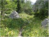 36
36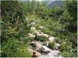 37
37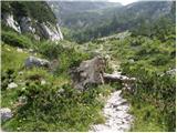 38
38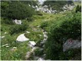 39
39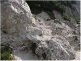 40
40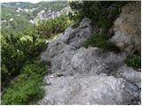 41
41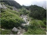 42
42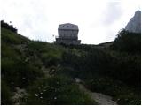 43
43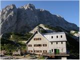 44
44
Discussion about the trip Suhadolnik - Cojzova koča na Kokrskem sedlu (via Taška)
|
| Gost14. 08. 2007 |
Brane V. From Kokrsko sedlo I returned via Taško, although it's recommended more for ascent. The entire path is newly arranged, appropriately secured with logs along the path, new steel cables, at the longest cable even a ladder made of trunks. Extremely commendable!
|
|
|
|
| BOSTJAN3413. 07. 2009 |
I'm wondering if anyone is going on Sunday 19.7.09
to the meeting of Kamnik mountains lovers at k.sedlo?
Greeting..
|
|
|
|
| Skuta14. 07. 2009 |
I'm more interested in what the road to Suhadolnik is like, given these storms, can it be driven nicely to the top?
|
|
|
|
| klavdy627. 06. 2010 |
Nicely routed and secured path, crumbly in some sections.
|
|
|
|
| velkavrh1. 08. 2010 |
I like using this trail for the ascent. Today caution was necessary because it was soaked - slippery. For the descent now I always use the usual trail.
|
|
|
|
| mero5514. 09. 2010 |
Nicely maintained path, we returned via the old path, also nice, only down in the gully it gets a bit lost
|
|
|
|
| velkavrh18. 06. 2011 |
Since last year I've advanced by a month and a half, started this early up here. As usual via Taško up. Path OK. Only the last ladder is in poor condition - be careful and before the summit there's a loose peg - carefully, because there's an abyss below. Today windy and a bit cold, so the whole visit was in the hut, even a large group of Croats. For many hikers this was the final goal, few went on to Grintavec. I went further anyway, but to final goal-Skuta, just because of weather conditions I didn't go. Such dense fog from the bivouac onwards past Grintavec that you could cut it. Mainly climbers from the Kamnik direction. They're hiking everywhere already. When returning from bivouac two went past bivouac to the saddle and on to Grintavec, almost at the car hikers heading to Kalški greben. Nice regards to mountaineer Franči with the black dog who greeted me so friendly at the hut! There are still real mountaineers!
|
|
|
|
| roker68. 03. 2012 |
Very well traced, nicely maintained path, destroyed by snow only one ladder, but no problems.
|
|
|
|
| Loni8. 03. 2012 |
I think that ladder was already destroyed before, not from this year's snow.
|
|
|
|
| svetilka22. 07. 2013 |
Interesting path, adequately secured, well maintained, nicely marked. Like most, I recommend it for ascent, for descent the old path.
|
|
|
|
| Anansie29. 05. 2016 |
Was up there yesterday. Hut closed. Looked for the stamp and didn't find it. Is it possible it's not outside the hut?
|
|
|
|
| nahaha11. 07. 2016 |
Was up there on Saturday. First time on this trail and thrilled. Careful on the section where we leave the road and turn left into the forest (picture no. 6). Due to branches the markings are less visible.
|
|
|
|
| anč30. 06. 2019 |
Today up via Taško and down via hunter's path. The path via Taško is destroyed, in the lower part deposits of stones, sand and mud. Above the last ladder there is no path anymore, pegs are broken. Hunter's path also destroyed. Shame there are no notices.
|
|
|
|
| Gost30. 06. 2019 |
The old path in the gully has been like that since it was reopened. You have to use your hands once or twice a bit. The path over Taško is nicely maintained and passable, and no worse than most paths in our mountains.
|
|
|
|
| ivoma30. 06. 2019 |
The path was damaged by the storm on 22.6., some of it was repaired the same day.
|
|
|
|
| anč30. 06. 2019 |
Yes ivoma, I read in the media that there was a storm on 22.6. Because I was abroad I didn't have this information. Obviously miro krivec didn't move to Cojzova after that date. The path is destroyed and dangerous Especially over Tasko. I have walked the path many times before and it was very well maintained previously, now on some sections it doesn't exist at all.
|
|
|
|
| angel22. 07. 2019 |
The path via Taško will be CLOSED for a while, but we will repair the old path as soon as possible.
|
|
|
|
| Matija8812. 08. 2019 |
Any new information regarding the openness and repair of the path over Taško?
|
|
|
|
| angel212. 08. 2019 |
The path over Taško is still closed, detour via the Old path.
|
|
|
|
| benja815111. 09. 2020 |
Hello, what is the current condition of the path via Taško? PZS says the damage from last year has been repaired, but I wanted to make sure anyway.
Best regards
|
|
|
|
| mirank12. 09. 2020 |
At the end of August I saw a post that the path has been fully repaired
|
|
|
|
| Enka30. 06. 2023 21:23:15 |
The path above the first ladder has collapsed, going down it might be a bit tricky for about a meter (slippery scree).
|
|
|
|
| Barbara 7527. 04. 2025 20:23:32 |
Hello hikers, has anyone been to Cojzova koča recently? I'm interested if the conditions are still wintery, or if the trail is without issues, thanks, Barbara
|
|
|
To post a comment you must log in:
If you do not yet have a username, you must first
register.