Suhadolnik - Cojzova koča na Kokrskem sedlu (old path )
Starting point: Suhadolnik (901 m)
| Latitude/Longitude: | 46,3352°N 14,5102°E |
| |
Route name: old path
Walking time: 2 h 45 min
Difficulty: partly demanding marked way
Elevation gain: 892 m
Elevation difference along the route: 915 m
Map: Kamniške in Savinjske Alpe 1:50.000
Recommended equipment (summer): helmet
Recommended equipment (winter): helmet, ice axe, crampons
Views: 44.006
 | 4 people like this post |
Access to starting point:
From the Ljubljana - Jesenice highway, take the exit Kranj - east and follow the road ahead in the direction of Jezersko, but only to the village of Kokra. In the mentioned village, we will notice a road a few meters before the road crosses the bridge over the river Kokra that runs towards Suhadolnik. The turn-off of the road is located when we are on the right side of the river (left bank); the road sign is approximately 7 km. We follow this road to a parking lot, which is located approximately 300 m before the farm Suhadolnik.
Route description:
At the beginning of the parking lot, we notice hiking signposts, which point us to a road, on which in less than 5 minutes of walking we arrive at a smaller crossroad by the farm Suhadolnik. Here we continue on the right road, which we follow for approximately another 5 minutes, or to the spot where the blazes lead us onto an ascending cart track. Further on, we ascend briefly along the cart track, then the blazes direct us right onto a footpath that moderately ascends through the forest. Higher up, we return to the cart track, which a few meters further brings us to a forest road, which we follow to its end (this takes approximately half an hour).
At the end of the road, the marked path splits into two parts. We continue on the right path in the direction of Cojzova koča on the old path (the left path (over Taška) is somewhat shorter and also technically somewhat more demanding).
At first we still walk along the road, after some 10 m it turns into an ascending cart track, from which a marked footpath soon branches off slightly to the right. The path first ascends parallel to the cart track, then turns somewhat to the right and quickly brings us to the lower part of a mighty gully. To the constriction of the gorge we ascend along the torrent bed, then the blazes direct us left onto a quite steep path that leads us further along a somewhat exposed slope. Higher, the path temporarily passes into a belt of dwarf pines, then brings us to steep slopes that are especially dangerous for slipping when wet. This is followed by approximately 15 minutes of traversing these slopes, where emergency fences assist us on the most exposed sections.
Higher, the path over Taška joins us from the left, and the slope we are walking on quickly flattens. This is followed by a short traversing ascent to the right and the path brings us to a larger plain, where the "old hut" once stood. Through high grass we walk to the other side of the plain, where we arrive at a marked junction.
We continue straight ahead (left to Kočna over Dolce) along a moderately steep path that ascends further through a belt of scrub. Higher up, the path temporarily flattens completely, then brings us among the dwarf pines, where it begins to ascend more steeply. We follow this somewhat steeper path, from which increasingly beautiful views open up, all the way to Cojzova koča na Kokrskem sedlu.

The trip can be extended to the following destinations: Kamniška koča na Kamniškem sedlu (5 h 30 min),
Kalška gora ( 45 min),
Bivak pod Grintovcem (1 h),
Kalški greben (1 h 30 min),
Turska gora (3 h 30 min),
Štruca (2 h 40 min),
Dolgi hrbet,
Kokrska Kočna (3 h),
Skuta (3 h),
Jezerska Kočna,
Grintovec
Photos:
 1
1 2
2 3
3 4
4 5
5 6
6 7
7 8
8 9
9 10
10 11
11 12
12 13
13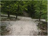 14
14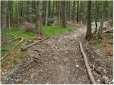 15
15 16
16 17
17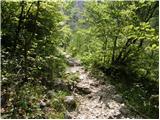 18
18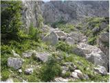 19
19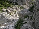 20
20 21
21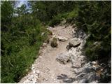 22
22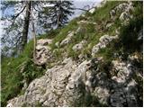 23
23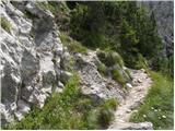 24
24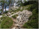 25
25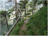 26
26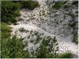 27
27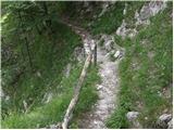 28
28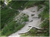 29
29 30
30 31
31 32
32 33
33 34
34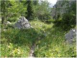 35
35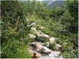 36
36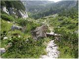 37
37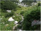 38
38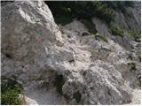 39
39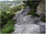 40
40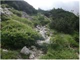 41
41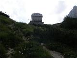 42
42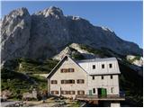 43
43
Discussion about the trip Suhadolnik - Cojzova koča na Kokrskem sedlu (old path )
|
| Gost14. 08. 2007 |
Brane.V. Very nice, short tour, suitable also for the afternoon if the afternoon weather is nice.
|
|
|
|
| Enka10. 09. 2009 |
We climbed to the saddle on Sunday. The trail is quite strenuous for people like us - more beginners with children - especially where it turns sharply left under the ridge, it's also a bit tricky. Otherwise, it's a very beautiful, varied and fairly scenic trail, richly adorned with views from the saddle itself.
|
|
|
|
| svetilka22. 07. 2013 |
I used this path for the return from the hut. In the torrent there are no marks or they are poorly visible, but you just have to persist, they reappear in time.
|
|
|
|
| laik31. 07. 2013 |
on Sunday I plan to go to Kokrsko sedlo...based on what I've read this variant seems the most suitable for a beginner...will it go quickly? THANKS for the advice and good luck to all
|
|
|
|
| balon18. 08. 2013 |
how was it at the saddle?
|
|
|
|
| laik18. 08. 2013 |
balon, if you're asking me - I don't know (yet) 
|
|
|
|
| slavkoo27. 08. 2014 |
On Friday I'm heading to Cojzova koča na Kokrskem sedlu. Which path is "less strenuous": from Suhadolnik via Taško or from the parking lot V Koncu above Kamniška Bistrica? And say comparison with Mala Mojstrovka? Thanks!
|
|
|
|
| Enka27. 08. 2014 |
Via Taško in my opinion passes quickest, because it's the most varied. For MM do you mean the southern approach?
|
|
|
|
| slavkoo27. 08. 2014 |
Yes, I mean the southern approach to MM. Probably I'll really go via Taško, back via the old path. Thanks Enka.
|
|
|
|
| Enka27. 08. 2014 |
I only descended from MM on this path and remember it as very difficult, because it requires a steady step all the time, as all surfaces are such that one slips very quickly. That's a small section of the old path from Kokrsko sedlo there in the gully or below it. The steepness is comparable in my opinion, but over Taško it is technically slightly more demanding, as there are also a couple of pegs, staples and a few meters of cable - but all that is just aid for the ascent and poses no problems. Both paths to Kokrsko sedlo from the lake side require great caution when wet.
|
|
|
|
| serajko27. 08. 2014 |
Hi
If it's wet, both directions from Suhadolnik are a bit tricky. In that case, I recommend the Kamniška side. Time-wise and elevation-wise they are comparable (difficulty-wise not). Good luck
|
|
|
|
| slavkoo28. 08. 2014 |
Thanks to both. If the weather clears up, I'll go to Cojzova from Suhadolnik, if it's more "so-so" then rather to Golica... no mountain "runs away".
|
|
|
|
| lovelife8212. 08. 2015 |
Today visited Kokrško sedlo via the mentioned path. The path is super described, only on the way back we didn't find the markings for the last entrance from the road into the forest so we went part of the way along the road (which is not at all car-friendly).
Otherwise, as already said, a varied path, some climbing and a lot of caution
|
|
|
|
| TomKepi20. 09. 2015 |
Hello
Next week on 27.09.2015 I plan to go up with my dog (shepherd 40 kg). Is the trail suitable for a dog or should I go from the Kamnik side?
Thx
|
|
|
|
| Enka20. 09. 2015 |
If he's used to hiking in the hills, there shouldn't be any problem. Our cocker spaniel enjoyed it 
|
|
|
|
| TomKepi21. 09. 2015 |
Thanks Erika. Our Lump has already hiked about 30 SLO mountains that are marked as "Easy marked trail". I was only worried if there are any pegs or other safety obstacles on this trail that a dog can't pass.
|
|
|
|
| serajko21. 09. 2015 |
regards
I'll write a bit more about this trail myself. The only place where care is needed is at the beginning of the ascent from the rocky gully to the left upwards. Due to the sand it's dangerous that the upper one triggers stones on the lower one, so I recommend a larger "safety distance". Our Tibetan terrier was jumping on the rocks. This trail was also used to access sheep to higher pastures.
|
|
|
|
| Enka21. 09. 2015 |
I think there is even a peg or two around picture 23 somewhere, but the dog can climb up the rocks.
|
|
|
|
| robi210729. 11. 2016 |
Today I went along this path to Cojzova koča and back. The path is well marked, so no orientation problems. It is steeper than from the eastern side (from Konca), twice or three times you have to put down the poles and climb over a rock, but even a complete beginner can manage the path if they have some fitness. Don't be scared by the label "partly demanding path" in the upper description, which in my opinion is due to those two or three rocks that need to be climbed over. Basically, the path is marked on hiking signs as easy, so go boldly. Of course, more caution is needed, especially when crossing steeper slopes, as the path goes quite close to the edge several times.
|
|
|
|
| AJDI10. 08. 2020 |
On Saturday we set off on this path and would like to warn others who are interested:
1. the path is very poorly marked - right at the start there is no sign at all where to go from the parking lot (the correct path is buried and hidden behind a pile of large stones, so we walked 45 minutes on the completely wrong path, as it was impossible to find even the starting point); (the correct path is buried and hidden behind a pile of large stones, so we walked 45 minutes on the completely wrong path, as it was impossible to find even the starting point);
2. the path is very poorly marked - there are mostly no signs, instead marks on the ground and on stones, which are completely faded in many places; - there are mostly no signs, instead marks on the ground and on stones, which are completely faded in many places;
3. the path is definitely not easy, and especially not suitable for children or dogs - in many places it is quite dangerous because the path is so worn and trodden, cables or other safety devices (like fences) have not been installed for a long time; - in many places it is quite dangerous because the path is so worn and trodden, cables or other safety devices (like fences) have not been installed for a long time;
4. at two points on the path pegs need to be used (so for those to whom this does not suit - this path is not for you) ; ;
5. at the end the path ascends very steeply for quite some time - it is pleasant otherwise, but you walk on rocks and need to scramble in several places (requires extra attention especially on descent).
|
|
|
|
| Enka14. 08. 2020 |
For those not used to hiking in the mountains, the path is of course not entirely easy. It surprised us a little too when we did it the first time (with two children and a dog ), but it taught us a lot. I fell in love with it and repeated it many more times and upgraded it with peaks above the saddle.
|
|
|
|
| ppegan15. 08. 2020 |
Yes, how is it not marked?? If you read the above description, you wouldn't have trouble knowing where to go, since there are signs at the starting point. I went there for the first time many years ago, and never had any problems. I also went several times on this path with dogs, and also across Taško, and they had no issues. Of course they are used to mountain paths, so one would have to exaggerate. OK, for small children it might really not be the best, I agree with that. Good luck
|
|
|
|
| Menace14. 09. 2023 12:39:02 |
Recently we tried this path, it's great otherwise, but I'd warn that a short section is really not suitable for beginners with vertigo.
Where you climb from the torrent above the abyss, the path goes directly along the edge, you need to use your hands and it's quite slippery due to scree. I know this doesn't pose problems for experienced hikers, but I almost "shit myself", so I think it's appropriate to warn that this path isn't exactly great for the inexperienced.
A colleague made a drone shot where the path is nicely visible: https://i.imgur.com/CLUW6sH.jpeg
|
|
|
|
| Enka27. 07. 2025 22:28:46 |
Is it true that the Old path has been repaired? I came across this information somewhere on FB, but on maPZS it is still marked as closed.
|
|
|
|
| Enka28. 07. 2025 14:44:14 |
Darxta, I don't believe FB posts, that's why I asked here.
Thanks for the link to bagi 's post. I don't know how I missed it, probably because there followed 2 pages of blabbering about prices in huts that have nothing to do with Grintavec, so I didn't look back enough.
Anyway, it's a pity, the approaches from Suhadolnik are/were very dear to me, the path from the other side is so unappealing to me that I probably won't turn up there for a long time.
|
|
|
|
| sla28. 07. 2025 14:53:24 |
For a normal mountaineer (not a tourist!!!) the path over Taško is passable.
I haven't walked the "old" path.
Both paths are marked as closed at the bottom and top near Cojzova koča!
|
|
|
|
| bo_zl28. 07. 2025 18:14:03 |
Enka, I assume the post that misled you, which would have misled me too, namely there was a post on pzs that the markers from PD Kamnik and help from Koroška associations have renovated the path from Suhadolnik to Cojzova koča. Probably they renovated the path from Konec, because judging by all the posts about the devastation above Suhadolnik, it will take quite a few weekends of hard work here for the path to be renovated.
|
|
|
|
| Enka28. 07. 2025 21:41:42 |
bo_zl, no, someone in one of the hiking groups explicitly wrote that the Old path from Suhadolnik is renovated and advised someone to go along it
|
|
|
To post a comment you must log in:
If you do not yet have a username, you must first
register.