Studeno - Gora (Sveti Lovrenc)
Starting point: Studeno (600 m)
| Latitude/Longitude: | 45,8267°N 14,174°E |
| |
Walking time: 1 h 5 min
Difficulty: easy marked way
Elevation gain: 419 m
Elevation difference along the route: 419 m
Map: Snežnik 1:50.000
Recommended equipment (summer):
Recommended equipment (winter):
Views: 30.094
 | 3 people like this post |
Access to starting point:
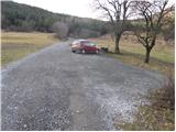
From the Ljubljana–Koper motorway, take the Postojna exit. Further on, we drive towards Postojna, and the road brings us to a junction where we continue right towards Ljubljana (old road). Near the church in Postojna, we turn left towards the village Studeno. We then follow this road to the mentioned village, in the middle of which we notice an older sign for Lovrenc. Here we turn left onto a narrower road that ascends between the houses. We follow this road for a few hundred metres to the parking lot at the start of the footpath to Lovrenc.
Route description:
A few metres from the parking lot, we notice the hiking marker for Sveti Lovrenc, which directs us across a meadow initially slightly uphill. Soon the path enters a pine forest, where it ascends gradually steeper and steeper. Somewhat higher, the forest becomes sparser and ever more beautiful views open up from the path. To the west we notice the slope of Nanos, and behind us we clearly see the Postojna basin and the Javorniki. The path, which runs straight uphill along the slope, leads us between pastures so that orientation, despite the sparse blazes, presents no problems. This beautiful panoramic path quickly brings us to the church of Sveti Lovrenc, where the path turns left into the forest. There follows a five-minute ascent through the forest to the summit, where a beautiful view opens up again.
Photos:
 1
1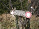 2
2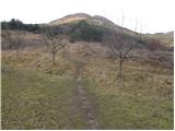 3
3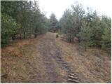 4
4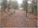 5
5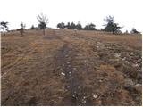 6
6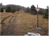 7
7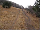 8
8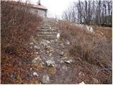 9
9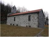 10
10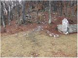 11
11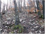 12
12 13
13
Discussion about the trip Studeno - Gora (Sveti Lovrenc)
|
| m30. 12. 2009 |
Hello!
Today fog covered Sv. Lovrenc, even though outside the pines it was quite windy. It was also raining or rather drizzling, so the mud wasn't too bad.
It's a nice ascent to stretch your legs a bit.  It's nicer though in the first half of June, when the Carniolan lily or golden apple, blue flax,... blooms and it's really all colorful flowers. It can be quite hot then and since the path is steep and sunny, it's accordingly sweaty. It's nicer though in the first half of June, when the Carniolan lily or golden apple, blue flax,... blooms and it's really all colorful flowers. It can be quite hot then and since the path is steep and sunny, it's accordingly sweaty.
Recommended.
|
|
|
|
| naokoli27. 07. 2011 |
Most beautiful in the snow, especially with skis or snowboard.
|
|
|
|
| ulmusglabra21. 12. 2011 |
Short but steep ascent from Studeno; I myself often go first from Planinska gora to Lipovec and then straight to Sv. Lovrenc.
LP
|
|
|
|
| bizgo933. 03. 2021 |
Oh you Lovrenc.
I've heard a lot about it and decided to climb up today. Lately I go to the mountains practically every day but Lovrenc really tired me out properly. The path starts gently ascending and after a few 100 meters turns into a very steep slope that doesn't level out drastically to the top. The path to the top is only just over 1.5 km long, giving an average gradient of 28%, on some sections I would say even over 40%.
Anyway, quite strenuous for the legs, but from the top above the church there is a magnificent view of the entire Pivška basin, Snežnik, Slivnica, Nanos, Javorniki and behind the forest also the Julian Alps with the prominent Triglav and Kamniške Alps.
So it's worth climbing up, especially on such a nice day as today.
|
|
|
|
| korab11. 03. 2023 14:37:52 |

This is a hill for checking fitness.
I don't know if it's only 28 percent incline. 1.9 km and 1 hour to the top.
However, everything is rewarded already during the hike with beautiful views.
It was sunny and clear, so the peaks were visible very far.
Come check autumn fitness
|
|
|
|
| Acibujl27. 03. 2025 18:33:02 |
27.3.2025
From the saddle above Lohača over Lipovec and Špilnik to Gora/Sv. Lovrenc. Beautiful hike, although it was quite windy. Along the way, picked some wild garlic, there are extensive growing areas. View towards the flooded Planinsko polje. Less visited peaks are these...
|
|
|
To post a comment you must log in:
If you do not yet have a username, you must first
register.