Studenice - Studenice castle (directly to castle)
Starting point: Studenice (260 m)
| Latitude/Longitude: | 46,2999°N 15,6138°E |
| |
Route name: directly to castle
Walking time: 10 min
Difficulty: easy marked way
Elevation gain: 55 m
Elevation difference along the route: 55 m
Map: Posavsko hribovje Boč - Bohor 1:50.000
Recommended equipment (summer):
Recommended equipment (winter):
Views: 2.235
 | 2 people like this post |
Access to starting point:
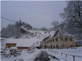
A) From the direction of Ljubljana we leave the highway at Slovenske Konjice and through Žič, Loče and Zbelovo we get to the center of Poljčane. In the center, we turn right in the direction of Studenice and after about three kilometers we reach Studenice, where we continue right across the bridge over the river Dravinja into the main part of the settlement. In front of the monastery complex we safely park.
B) From the direction of Maribor we leave the highway at Slovenska Bistrica, where signs point us to Poljčane. In the center, we turn left in the direction of Studenice and after about three kilometers we reach Studenice, where we continue right across the bridge over the river Dravinja into the main part of the settlement. In front of the monastery complex we safely park.
C) From the direction of Ptuj, Kidričevo through Ptujska gora, Majšperk and Makole we get to Studenice, where we continue left across the bridge over the river Dravinja into the main part of the settlement. In front of the monastery complex we safely park.
Route description:
After a short initial tour of the main part of Studenice, we continue left from the monastery complex past the parish house and the premises/cellars of Studenice winegrowers higher up to the castle. The path is easy to follow and somewhere beside the descendant of Maribor's old vine we reach the destination.
Photos:
 1
1 2
2 3
3 4
4 5
5 6
6 7
7 8
8 9
9 10
10 11
11 12
12 13
13 14
14 15
15 16
16 17
17
Discussion about the trip Studenice - Studenice castle (directly to castle)
To post a comment you must log in:
If you do not yet have a username, you must first
register.