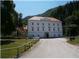
Studenice - Source of Topli (Studeniški) potok
Starting point: Studenice (260 m)
| Latitude/Longitude: | 46,2999°N 15,6138°E |
| |
Walking time: 5 min
Difficulty: easy marked way
Elevation gain: 35 m
Elevation difference along the route: 35 m
Map: Posavsko hribovje Boč - Bohor 1:50.000
Recommended equipment (summer):
Recommended equipment (winter):
Views: 4.917
 | 1 person like this post |
Access to starting point:
A) From the direction of Ljubljana we leave the highway in Slovenske Konjice and through Žiče, Loče and Zbelovo we get to the center of Poljčane. In the center, we turn right in the direction of Studenice and after about three kilometers we reach Studenice, where we continue right across the bridge over the river Dravinja into the main part of the settlement. In front of the monastery complex we safely park.
B) From the direction of Maribor we leave the highway in Slovenska Bistrica, where signs point us to Poljčane. In the center, we turn left in the direction of Studenice and after about three kilometers we reach Studenice, where we continue right across the bridge over the river Dravinja into the main part of the settlement. In front of the monastery complex we safely park.
C) From the direction of Ptuj, Kidričevo through Ptujska gora, Majšperk and Makole we get to Studenice, where we continue left across the bridge over the river Dravinja into the main part of the settlement. In front of the monastery complex we safely park.
Route description:
After a short tour of the main part of Studenice, we continue left from the monastery complex by the presbytery. In the passage/underpass between the presbytery and the winegrowers association Studenice we continue upwards on a cart track along the stone wall. To the left also the path to Studenice Castle branches off, higher and soon again to the left by the path a smaller stream, where water runs in a wooden trough. Further right by the path, entry through the iron door, old nuns' cemetery of Dominican sisters and Magdalene sisters, who marked the history of Studenice through turbulent centuries. Further left by the path a stone/wooden well and the remains of an iron/concrete skeleton of the quarry. The only "foreign object" which somehow blended into the environment. A few more steps and source/sources of the stream more or less rich with water. The area higher is typically somewhat similar to karst, limestone terrain and their water abundance depends on precipitation, snow melt. Some benches in the oasis of silence, peace and a smaller wooden footbridge for crossing the stream at higher water level and this is also approximately the goal of the short path, suitable practically for everyone.

Photos:
 1
1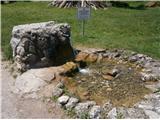 2
2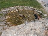 3
3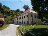 4
4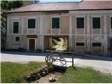 5
5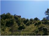 6
6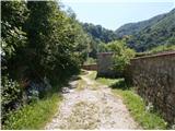 7
7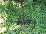 8
8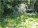 9
9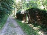 10
10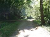 11
11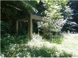 12
12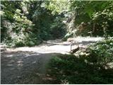 13
13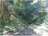 14
14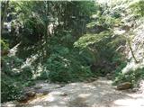 15
15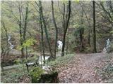 16
16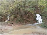 17
17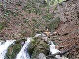 18
18 19
19
Discussion about the trip Studenice - Source of Topli (Studeniški) potok
|
| bruny6. 09. 2014 |
To the springs today. Water flow very similar to that in pictures 16,17 and 18. All four active, including the leftmost one. Third and fourth as usual with higher flow cloudy, somewhat brown/muddy water. Further on today high above the springs in the world of Boča and Plešivca, where what becomes the powerful stream is formed...In the vicinity of Formila it sinks distinctly into the underground water system. Maybe more on the conditions!?...
|
|
|
|
| bruny29. 03. 2015 |
Today start and end along the described path. It was very lively today in Studenice and along this path. The first ,,poljščine,, gatherers of the year - čemaž were collecting the medicinal plant. That's right, let's live with nature although a bit higher čemaž is even more pronounced...
|
|
|
|
| bruny23. 05. 2015 |
Higher into the world of Boča along the described path this afternoon and also descent... Water flow of the springs strong after a few days of abundant rains... springs slightly more watery than in pictures 16,17 and 18. Best regards
|
|
|
|
| bruny16. 01. 2016 |
In the afternoon in one of the snow showers that were "racing" over Boč and along the Dravinja river, a short bike ride to the source of the Studeniški/Topli stream and back to Poljčane. At the end also a short section along the Bela stream between Zgornje Poljčane and the confluence with the Dravinja river. There was very little Boč today, somewhat more near the water which mainly gathers from Boč into both streams. There was also some snow base for a mini January snow impression...Source of Studeniški/Topli stream and a little along Bela stream before confluence with Dravinja, 16.01.2016Lp
|
|
|
|
| bruny18. 10. 2020 |
On Boč it  rained and the spring rained and the spring  is quite full of water... is quite full of water...
|
|
|
|
| bruny13. 12. 2020 |
At the spring/s of the stream higher up in the world of Boča. Water flow ,,strong,, but somewhat less than in the photos above...Higher up today there has still not been a proper thaw...
|
|
|
|
| bruny31. 12. 2020 |
Still very watery, even today... Snow melt higher up and abundant rainfall is the right recipe for this karst-like world...
|
|
|
|
| bruny30. 05. 2021 19:08:43 |
Today. They are full of water. There was really a lot of rain in May...
|
|
|
|
| bruny26. 12. 2021 18:36:36 |
At the spring today higher into the world of Boča. A few centimeters of fresh snow and they are quite watery...
|
|
|
|
| bruny8. 05. 2022 18:54:08 |
Exceptionally watery spring today... Nighttime rain, even in the form of thunderstorms, was plentiful...
|
|
|
|
| bruny7. 06. 2022 13:18:38 |
It wasn't watery today. Not dried up either...
|
|
|
|
| bruny18. 12. 2022 17:07:18 |
At the spring higher up in the world of Boča...It was flowing!
|
|
|
|
| bruny16. 04. 2023 18:31:09 |
This afternoon... Three out of four springs are watery and active...
|
|
|
|
| jprim18. 04. 2023 11:55:06 |
@ bruny
Well, we were out on the terrain again, but this time no cyclists on the path, occasionally it was drizzling.
Crowded at the hut, but not hikers, some party. That day we met one female hiker.
The springs are really nice to see.
Cheers!
|
|
|
|
| bruny7. 01. 2024 14:35:05 |
Extremely watery today. Three out of four springs active. Temperature slightly above freezing and it's still lightly raining...
|
|
|
|
| bruny18. 01. 2026 14:28:48 |
Today on the ascent and descent along the described path. The spring is actively flowing...
|
|
|
|
| bruny29. 01. 2026 12:42:06 |
Very watery today - Rainfall at night and snow melting higher up in the world of Boča...
|
|
|
|
| bruny9. 02. 2026 11:54:00 |
Along the described path and also today distinctly full of water...
|
|
|
|
| bruny27. 02. 2026 16:19:34 |
After the abundant snowfall last Friday and full thaw they are extremely watery...
|
|
|
|
| bruny6. 03. 2026 19:11:00 |
It's still quite watery...
|
|
|
To post a comment you must log in:
If you do not yet have a username, you must first
register.