Stržišče - Črna prst (circular path)
Starting point: Stržišče (801 m)
Route name: circular path
Walking time: 9 h
Difficulty: partly demanding marked way
Elevation gain: 1043 m
Elevation difference along the route: 1500 m
Map: Škofjeloško in Cerkljansko hribovje 1:50.000
Recommended equipment (summer):
Recommended equipment (winter): ice axe, crampons
Views: 17.140
 | 0 people like this post |
Access to starting point:
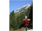
On the road Idrija-Tolmin we turn towards Podbrdo. A little further from Hudajužna the road branches off to the left towards Stržišče where we leave the car. Of course we can also come from the other side from Sorica.
Route description:
In Stržišče the path starts on the left side, if we are facing towards Črna prst. We head towards Rutarski gozd along the forest road which is occasionally marked and signposted with signboards. The path is at the same time also the Slovenian geological trail. In Rutarski gozd we come to the road, which slowly changes into a wide mostly rocky cart track. The path brings us to the hunting observatory and then soon to a junction, where we continue right in the direction of Rodica. Further, we ascend on a relatively well-preserved mule track first through the forest and then through dwarf pines. Moderately steep and increasingly scenic path. A little higher the path brings us to a side ridge of the Spodnje Bohinjske gore, from where a nice view opens up towards Kneške Ravne. The path from the ridge soon turns to the south slopes, which we then follow to the spot where we join the path from the Bohinj side. We continue right on a panoramic ridge path, which in about 10 minutes of additional walking brings us to the panoramic summit of Rodica. From Stržišče to Rodica we need 4 hours.
We then continue the path along the panoramic ridge in the direction of Črna prst. The path along the ridge lasts at least 2 hours. This is followed by the descent from Črna prst to Stržišče or Kal. These two villages are indeed very close and connected by a road.

Photos:
 1
1 2
2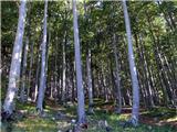 3
3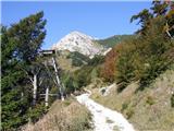 4
4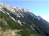 5
5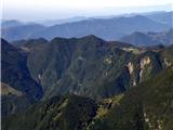 6
6 7
7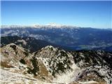 8
8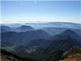 9
9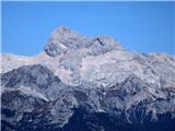 10
10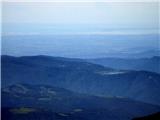 11
11 12
12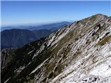 13
13 14
14 15
15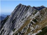 16
16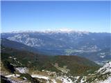 17
17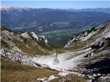 18
18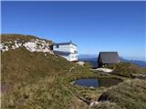 19
19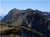 20
20
Discussion about the trip Stržišče - Črna prst (circular path)
|
| zomirp1215. 10. 2017 |
today 15.10.2017 we did this tour. Nice and long. I have a remark on the poorly marked path. From Črna prst towards Stržišče there should be some signs with directions. Also already higher in the forest, because the path turns in another direction than Stržišče and you are not sure if you are on the right path.
we actually made it via some hunter's path that leads directly to Stržišče. But it is steep
|
|
|
|
| mirank15. 10. 2017 |
As far as I remember the circular path described above is poorly or not marked at all in the section between Stržišče and Rutarski gozd. Descent from Črna prst and to Kala is no problem at all. Let someone correct me if it's not true, but I think they abandoned the direct path to Stržišče a few years ago?
|
|
|
|
| zomirp1216. 10. 2017 |
I agree with you, but from Stržišče to Rutarski gozd there is a precise description and no orientation problems. But when you descend from Črna prst and enter the forest there are quite a few paths that you don't know where they lead. Some signs wouldn't hurt. There is a direct one, as we took it. Locals say it's a hunting path, it's nicely cleared and mowed, but steep.
|
|
|
|
| zomirp1217. 10. 2017 |
Just one more thing to add. The parking in Stržišče is now new, large and arranged. Through the village along the road by the containers.
|
|
|
|
| mornar1. 10. 2018 |
Yesterday 30.9.2018 we walked the mentioned circular path. Path markings [are] a real disaster and the path time is not appropriate; we are good walkers but needed almost 8 hours.
|
|
|
|
| AlesBeg5. 10. 2018 |
04.10.2018 we hiked this circular trail.
Parked in the center of Stržišče, later when we returned we saw that there is a new large parking lot at the cargo cableway.
Due to somewhat poor markings, on the gravel road between Stržišče and Rut we turned left onto a narrow path towards Rut (sign Rut), thus extending the trail by approx. 1h. I would also warn about the poor markings on the descent from Črna prst towards Stržišče, especially during the forest section.
On the northern side of the ridge between Rodica and Črna prst there is still a little snow, but it does not hinder walking too much, just a little caution is needed.
To Rodica (via Rut) approx. 3:40h, to Črna prst another good two hours. For the entire tour we used approx. 8h of relatively fast hiking.
Very nice trail, somewhat long.
|
|
|
To post a comment you must log in:
If you do not yet have a username, you must first
register.