Štore - Tolsti vrh above Celjska koča (via Žlajfa)
Starting point: Štore (205 m)
| Latitude/Longitude: | 46,2213°N 15,3215°E |
| |
Route name: via Žlajfa
Walking time: 2 h 15 min
Difficulty: easy marked way
Elevation gain: 629 m
Elevation difference along the route: 735 m
Map:
Recommended equipment (summer):
Recommended equipment (winter):
Views: 1.999
 | 3 people like this post |
Access to starting point:
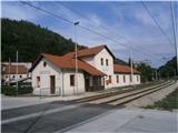
Štore is accessible ideally with the help of railways. By road... you leave the highway in Celje and practically in the center of Celje go towards Štore or Šentjur. You park the car near the Štore railway station, where there are enough parking spots available and there is also the beginning of the marked mountain path.
Route description:
The beginning of the path is at the railway station in Štore. Head over Voglajna, where a signpost immediately points right and soon straight ahead practically through the area of the old Štore ironworks. On the asphalt road continue in the lower part along Bojanski jarek to a new path junction, which directs sharply to the left on an asphalt surface higher uphill to Žlajfa, where the road finally turns into a forest path, which is solidly marked. The ascent is nice, alternating forest sections and meadow-pastoral areas. From the left the mountain path from Štore through Šentjanž or Resevna joins and after a shorter continuation through the forest you reach Almin dom na Svetini.
From Almin dom continue on the marked mountain path to Tolsti vrh, which you reach from the east side.
Photos:
 1
1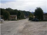 2
2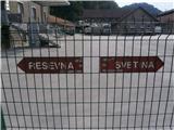 3
3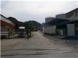 4
4 5
5 6
6 7
7 8
8 9
9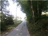 10
10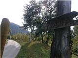 11
11 12
12 13
13 14
14 15
15 16
16 17
17 18
18 19
19 20
20 21
21 22
22 23
23 24
24 25
25 26
26 27
27 28
28 29
29 30
30 31
31 32
32 33
33 34
34 35
35 36
36 37
37 38
38 39
39 40
40 41
41 42
42 43
43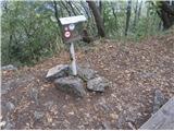 44
44
Discussion about the trip Štore - Tolsti vrh above Celjska koča (via Žlajfa)
To post a comment you must log in:
If you do not yet have a username, you must first
register.