Stary Smokovec - Slavkovsky štit
Starting point: Stary Smokovec (1030 m)
| Latitude/Longitude: | 49,139°N 20,2203°E |
| |
Walking time: 4 h 10 min
Difficulty: easy marked way
Elevation gain: 1422 m
Elevation difference along the route: 1450 m
Map:
Recommended equipment (summer):
Recommended equipment (winter): ice axe, crampons
Views: 2.590
 | 1 person like this post |
Access to starting point:
You can reach Stary Smokovec by car, parking at one of the parking lots in the town, or by the Tatra Electric Railway to the starting point, which also brings you to the town center.
Route description:
From the center of Stary Smokovec, go left uphill along the street, passing the Grand Hotel. After a few minutes, reach the signs for the start of the trail, marked blue.
The blue trail continues first along a stony track with lush undergrowth, and this path goes almost to the junction with the Tatranská Magistrála (red-marked trail). It takes about 1 hour to get there.
After the junction, the trail enters the forest, and after half an hour of further walking, reach the first attractions along the trail, namely Slavkovská Vyhliadka (1531 m).
From Slavkovská Vyhliadka, enjoy a beautiful view of the Velike doline, the peaks on the other side of the mentioned valley, and Lomnický štít behind them.
From here, the trail continues over granite slabs, partly through scrub (dwarf pine). The trail further passes the peak Nos (2273 m), then follow a fairly steep path, partly over granite slabs, partly over grass, and one part also over short scree slopes, all the way to the 2452 m high summit, where a metal cross stands.

Along the route: Slavkovská Vyhliadka (1531m), Nos (2273m)
Photos:
 1
1 2
2 3
3 4
4 5
5 6
6 7
7 8
8 9
9 10
10 11
11 12
12 13
13 14
14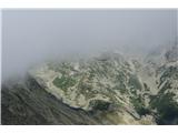 15
15
Discussion about the trip Stary Smokovec - Slavkovsky štit
To post a comment you must log in:
If you do not yet have a username, you must first
register.