Smolnik - Koča na Klopnem vrhu
Starting point: Smolnik (277 m)
Walking time: 3 h
Difficulty: easy marked way
Elevation gain: 983 m
Elevation difference along the route: 1179 m
Map: Pohorje 1:50.000
Recommended equipment (summer):
Recommended equipment (winter):
Views: 8.454
 | 1 person like this post |
Access to starting point:
Smolnik is a settlement on the west side of Ruš. From the center of Ruš we drive straight towards the west on the asphalt road for Lovrenc, past the cemetery on the right side, in Smolnik below the characteristic railway viaduct the road turns sharply right, then straight to the industrial hall, where on the right side of the road there is an advertising sign GEBERIT. Here a traffic sign marks a larger asphalt parking lot on the left side of the road, where we park the car. From the center of Ruš a little less than 2 km.
Route description:
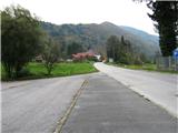
From the parking lot we head on the road towards the west, after approx. 300 meters before the last house on the left side we turn left, as indicated by the signpost for ZGORNJI SMOLNIK. On the cart track upwards on the northern slope of Kluž, through a smaller underpass we cross the railway, the path turns right and past a smaller farm brings us to the forest. If we step on the edge of the cart track, a view opens up on the river Drava and the hills on the other side of the river. The path winds in serpentines through mainly deciduous forest, in between there is a sharp left turn-off of the path to Šumik (through the valley of Lobnica), we arrive at a narrow asphalt road (*30 min), the next 2 km we will walk on it. We are on the western bank of the Lobnica valley, whose murmuring we hear deep below us. From the left side a view opens up on the steep forested slopes of the opposite side of the valley, clearly visible is the mighty Marolt homestead. We will encounter a few more such farms on our path, they are cultural monuments and have carried their names for a long time, even though the owners have changed in some places. We continue on the road below Globokarjev vrh, after a while we notice a neat chapel above the road and arrive at the saddle directly near the Globokar homestead (*20 min). To the right towards the northwest a view opens up on a part of the Drava valley. Clearly visible is Falska pečina, and behind it Falska graščina, which is first mentioned in 1245, while the current layout dates from 1407. Upstream along the river the oldest Drava hydroelectric power plant Fala is visible, completed in 1918, the machine room from that time is fully preserved and today represents the largest such technical monument in this part of Europe. The road ascends evenly, before the Harič homestead the asphalt ends, after a few minutes past the Cebe homestead as well, slightly downhill and immediately at the bend we turn off the road to the left uphill into the forest (*15 min). On the cart track we soon come upon a somewhat hidden NOB memorial plaque, at this spot on 17.07.1942 there was a clash of the patrol of Ruška četa with German gendarmes. Through the forest we arrive at the meadow below Švajgerjeva homestead, we cross the meadow on the right side along the edge of the forest uphill. We arrive at a junction, we continue on the road right uphill and immediately then left, we arrive at a small church (*35 min). The church was built in 1860 on his estate by farmer Luka Hleb, the structure is under renovation. It is surrounded by a small cemetery, here is the tomb of the Hleb family. On the more than a hundred years old tombstones there are inscriptions in Slovenian, which testifies to the firm national consciousness of the local inhabitants. Right next to the church is a fork - the left path is for Šumik, we continue right uphill into the forest. After a while unexpectedly on the right side a view opens up on Ruš, a little farther also part of Maribor. A pleasant, almost level path leads us comfortably through the forest, we cross a few smaller streams and at the bridge over Lamprehtov potok we arrive at the macadam road that leads to Klopni vrh (*50 min). On the road left uphill, across the wooden bridge again over the stream to Fišerjeva žaga i.e. Stara Glažuta (*10 min). Of the sawmill and the glassworks only the names have been preserved, today there are recreational objects here. At this spot we turn left into the forest and along a somewhat steep path we arrive at the clearing, where the Koča na Klopnem vrhu is located (*20 min).

Photos:
 1
1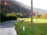 2
2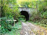 3
3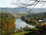 4
4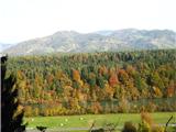 5
5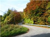 6
6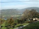 7
7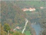 8
8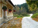 9
9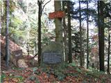 10
10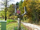 11
11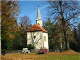 12
12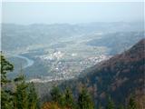 13
13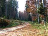 14
14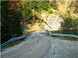 15
15 16
16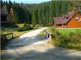 17
17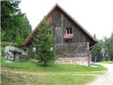 18
18
Discussion about the trip Smolnik - Koča na Klopnem vrhu
|
| gasilec23. 10. 2008 |
In Ruše, traffic signs warn that the road Ruše - Lovrenc is closed or only passable to Falska Pečina (presumably until 30.11.2008). For the mentioned trip, this poses no problems, as our starting point is about 2 km before the mentioned closure.
|
|
|
|
| klavdy617. 04. 2010 |
The trail is longer at this time due to fallen trees, mud and snow, of which there is still quite a bit just before the hut. Otherwise a very interesting trip.
|
|
|
To post a comment you must log in:
If you do not yet have a username, you must first
register.