Slivnica pri Mariboru - Mariborska koča
Starting point: Slivnica pri Mariboru (292 m)
Walking time: 2 h 30 min
Difficulty: easy marked way
Elevation gain: 794 m
Elevation difference along the route: 805 m
Map: Pohorje 1:50.000
Recommended equipment (summer):
Recommended equipment (winter): ice axe, crampons
Views: 6.156
 | 2 people like this post |
Access to starting point:
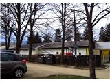
A) From the direction of Ljubljana on the highway, we take the Maribor-center exit. At the next traffic-light intersection, we turn left and drive straight for approx. 2 km to the center of Slivnica pri Mariboru. On the right, we will notice the primary school and then the kindergarten. We turn right into the parking lot. Nearby there are also wooden sculptures.
B) From the direction of Maribor, we drive on the southern access road in the direction of the settlement Hoče. At the traffic-light intersection, we turn right in the direction of Slivnica pri Mariboru. After approx. 2 km we arrive at the center of the settlement, where on the right we notice the primary school and then the kindergarten. We turn right into the parking lot; nearby there are also wooden sculptures.
Route description:
From the parking lot, we go left, where already at the beginning we notice the blazes. Along the linden avenue (new kindergarten on the right side) to the metal turnstile gates. Across the school playground and by the field on the left side in the direction of Slivniški grad castle. At the castle, which is in decaying condition, we turn left onto the road. We go along the road to the electric transformer, where we turn right onto the path. Along the edge of the forest transversely; when we step onto the asphalt road, we go right. The road ascends slightly along the slope. At the next intersection, we turn right onto the first branch-off. Past some houses, when the path enters the forest it ascends through the forest, higher transitioning to the edge thereof, where on the left we see the Rec farm (475 m).
From here, we walk along the ridge the entire time. After exiting the forest, a panoramic view opens up of Framsko, Slivniško, and Hočko Pohorje. The path continues through the Šestdobe settlement. At the path intersection, we turn by the "sower" wooden sculpture along the left road upwards, where a blaze on the power pole directs us back into the forest, which is short. We step onto the road again and head left. We walk along the road for approx. 1 km, or until the point where the path from Fram (Jugova pot) joins from the left. At this spot, there is also a wooden sculpture of a human hand. We continue along the road with the path over Plahutnikov vrh (687 m) to the Plahutnik farm. A directional sign directs us uphill along the slope toward the lung disease hospital. We go through the hospital yard when crossing the Hoče-Belvi road. At the traffic sign, we turn right into the forest. After a few minutes of ascending, we step back onto the Hoče-Belvi road. We walk along the road for approx. 500 m, then again left following the blaze. The footpath ascends through the meadow, crosses the road again, and transitions to a macadam road. This brings us to Petkovo sedlo (881 m). We go straight past the "Na prepihu" snack bar to the next intersection. Straight along the bushes upwards to the forest edge, where a large blaze is visible from afar. The path ascends through the forest again and then crosses the road once more. We reach the forest edge by a religious symbol, where we can already see the Mariborska koča hut. A short stretch through the forest, we step onto the road; in the middle of the apartment settlement, we head left. Within the next 5 minutes, we arrive at the Mariborska koča hut (1068 m).

Photos:
 1
1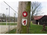 2
2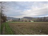 3
3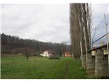 4
4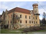 5
5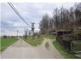 6
6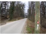 7
7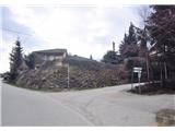 8
8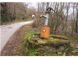 9
9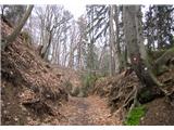 10
10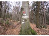 11
11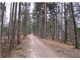 12
12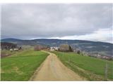 13
13 14
14 15
15 16
16 17
17 18
18 19
19 20
20 21
21 22
22 23
23 24
24 25
25 26
26 27
27 28
28 29
29 30
30 31
31 32
32 33
33 34
34 35
35 36
36 37
37 38
38 39
39
Discussion about the trip Slivnica pri Mariboru - Mariborska koča
|
| bruny20. 05. 2014 |
Just a "small" interesting fact. While reading the description of this trail, picture number 21 surprised me and how Ranče somehow "overnight" became Šestdobe, even though it was still Ranče at the beginning of January 2013 last year when I was walking in that area. Last year I took the same shot and it said Ranče. A bit of searching on the net and I quickly resolved my doubts...Source Lex localis. Šestdobe is supposed to be the old historical name for that part of Ranč and the locals succeeded with their initiative to achieve the renaming. Of course, Ranče still remains to some extent. Thanks for the nice description.
|
|
|
|
| pohodnik3820. 05. 2014 |
Thanks Ranče is on the other side if going from Fram as a small hamlet with a few houses. I learned about this trail by chance when I was in Slivnica on business, took the book and of course it's nicely described, but it's not drawn on Geopedija. And it's excellently marked. Ranče is on the other side if going from Fram as a small hamlet with a few houses. I learned about this trail by chance when I was in Slivnica on business, took the book and of course it's nicely described, but it's not drawn on Geopedija. And it's excellently marked.
|
|
|
|
| bruny23. 05. 2014 |
Also an interesting fact about picture no. 2... Yes, the path from Slivnica was years ago, I'll say actually decades ago the introductory informal section of the Slovenian Mountain Trail to the first stamp at Mariborska koča.
Times when there were still few cars, here and there some ,,fičak, katrca, hrošč,,… public transport of course a social category and cheap. The railway station in Slivnica a point from which after a few meters they already practically reached Pohorje and there was no need to go through ,,cejli,, Maribor ,,štancat asfalt,, to Spodnje Radvanje. They extended Friday to Sunday, nicely across Pohorje, slept twice in koče and returned from Slovenj Gradec one way or another. Then came years when the first stamp at Mariborska koča was mainly a nice family outing with lunch for two or family, new car and extension to Ruška koča for the second stamp and  for the Pohorje omelette… Now the times are somewhat returning again, partly also with the help of mountain running and lack of time, trekking, cycling… and tours across Pohorje are gaining prominence again, in one/two days the necessary stamps are obtained to Slovenj Gradec, Uršlja gora and that's it and that's how it should be. for the Pohorje omelette… Now the times are somewhat returning again, partly also with the help of mountain running and lack of time, trekking, cycling… and tours across Pohorje are gaining prominence again, in one/two days the necessary stamps are obtained to Slovenj Gradec, Uršlja gora and that's it and that's how it should be.
Written somewhat in the style of the movie...Uncles told me...Mountain veterans told me.
|
|
|
|
| pohodnik3823. 05. 2014 |
Great, thank you it made me think when I was walking this path that there must be some connection with the transversal. But I didn't know that it actually started here in the past. Today I was officially at the place where it now starts and some ideas are already being made; if the weather is whimsical, a circular variant might come about.
|
|
|
|
| bruny23. 05. 2014 |
Phew, don't teach ,,wrong faith,,... in the first sentence I wrote ,,introductory informal section,, for some it was from Slivnica. The official and real start was definitely, still is and always will be Spodnje Radvanje, the founder and initiator Mr. Ivan Šumljak already knew why. Best regards
|
|
|
|
| b0li29. 02. 2020 |
Nice trail, but Pohorci wouldn't be Pohorci if they didn't all have dogs loose at houses without fences. 
Whoever goes alone should be careful...
|
|
|
To post a comment you must log in:
If you do not yet have a username, you must first
register.