Slavkov dom na Golem brdu - Jeterbenk
Starting point: Slavkov dom na Golem brdu (396 m)
| Latitude/Longitude: | 46,1055°N 14,4169°E |
| |
Walking time: 1 h 15 min
Difficulty: easy marked way
Elevation gain: 378 m
Elevation difference along the route: 420 m
Map: Ljubljana - okolica 1:50.000
Recommended equipment (summer):
Recommended equipment (winter):
Views: 29.654
 | 5 people like this post |
Access to starting point:
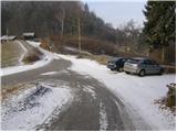
A) Access from Ljubljana: From Ljubljana, we drive towards Medvode but only to the village Medno. Here we turn left and drive past the hotel, after which we soon come to an intersection, where we continue left towards Golo brdo and Žlebe. The road then takes us through Seničica, where we continue straight in the direction of Golo brdo. The road then brings us to the next intersection, where a marked path to Golo brdo branches off to the right. Here we continue straight as well and drive further approximately 1 km to the next intersection, where we turn right. We follow this road to a smaller parking lot, which is situated a few dozen meters below Slavkov dom. On the larger parking lot at the mountain hut, parking is allowed only for guests.
B) Access from Medvode: From Medvode we drive towards Ljubljana. At the last traffic light in Medvode we turn right over the railway track and then continue left. At the intersection a little before the hotel in Medno we turn right and the road then brings us to the village Seničica. Further, follow the above description.
Route description:
From the parking lot, we continue on the road upwards (not in the direction of Slavkov dom), which after a few dozen steps brings us to mountain signposts. Here the path to Jeterbenk directs us left onto a cart track steeply upwards. The steepness of the cart track soon eases and it changes into a pleasant footpath. The path then brings us onto a wide cart track, which we follow to the left. After half an hour of walking from the hut this cart track also turns into a footpath, which starts to ascend more steeply. The path ahead has quite a few junctions but it is well marked everywhere (we stick to the direction Jeterbenk). The path eventually passes onto the side ridge of Jeterbenk along which it ascends steeply and occasionally descends for a short time. This path, which a few steps below the summit joins the path from Katarina, we follow all the way to the top.
Photos:
 1
1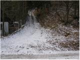 2
2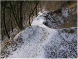 3
3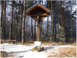 4
4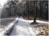 5
5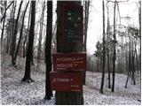 6
6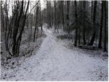 7
7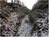 8
8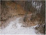 9
9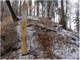 10
10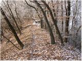 11
11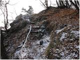 12
12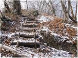 13
13 14
14
Discussion about the trip Slavkov dom na Golem brdu - Jeterbenk
|
| Lisica5. 01. 2011 |
Very nice excursion. At the second vertical signpost with markers I went the wrong way and ended up back in the valley, then back again and steeply UP in the right direction. In my opinion, it's a bit poorly marked at the turn (at that second vertical signpost), Katarina and Jeterbenk should be marked in the same direction but they aren't.
|
|
|
|
| viharnik5. 01. 2011 |
Usually we already turn right at Pri Hrastu onto the main Jeterbenk ridge, which is clearly visible. There the path leads along the ridge all the way to the summit.
The other variant is the Katarina route, where on the ridge at the chapel of St. Mary we turn right past it and in 15min to the summit. There you really can't get lost, Lisica, as the paths are literally erosion toboggan runs to Katarina. Lp
|
|
|
|
| Lisica5. 01. 2011 |
Thanks. If it's your first time somewhere it's obviously not that simple.  In this cold you rarely meet anyone to ask. In this cold you rarely meet anyone to ask.
|
|
|
|
| caplja10. 01. 2011 |
Given that you're a vixen, it still seems strange to me that you got lost on such well-marked trails.
From my experience, the markings around Povhograjci are still among the best in Slovenia. We should take a little more time to look around if we don't know the trail well. And we'll notice some nice flowers too. If we rush like that, we'll think we're at work. And bon appétit I wish you in our good inns and refreshment spots. Have a nice time.
|
|
|
|
| Lisica1. 12. 2012 |
Chaplja, today I was already x times on Jeterbenk since then, and now I know all the paths around. :-) Jeterbenk is a real little gem among the hills around Ljubljana for me. 
|
|
|
|
| viharnik1. 12. 2012 |
Lisica, besides the two mentioned paths to Jeterbenk there is also an intermediate path a bit higher from the oak on the Slavkov dom-Katarina path to the right. By this path you reach a bit higher on the ridge eastern path of Jeterbenk.
|
|
|
|
| Botko23. 02. 2014 |
The trail is currently impassable due to numerous fallen trees.
|
|
|
|
| Lisica16. 03. 2014 |
You can get to Jeterbenk via the path to Katarina and past the weekend house to the top, the ridge at the top is nicely passable, the path past the little church is impassable, as are all lower paths, except the already mentioned path to Katarina, on this one you occasionally have to climb over trunks or crawl under them. Varied.
|
|
|
To post a comment you must log in:
If you do not yet have a username, you must first
register.