Slavkom dom na Golem brdu - Sveta Katarina (Topol)
Starting point: Slavkom dom na Golem brdu (396 m)
| Latitude/Longitude: | 46,1055°N 14,4169°E |
| |
Walking time: 1 h 30 min
Difficulty: easy marked way
Elevation gain: 342 m
Elevation difference along the route: 370 m
Map: Ljubljana in okolica 1:50.000
Recommended equipment (summer):
Recommended equipment (winter):
Views: 28.896
 | 1 person like this post |
Access to starting point:
A) Access from Ljubljana: From Ljubljana, we drive towards Medvode, but only to the village Medno. At the end of the village, we turn left and we drive past the hotel after which we soon come to a crossroad, where we continue left towards Golo brdo and Žlebe. The road then runs through the village Seničica, where we continue straight in the direction of Golo brdo. The road then brings us to the next crossroad, where a marked path branches off to the right to Golo brdo. Here we continue straight as well and we drive further approx. 1 km to the next crossroad, where we turn right. We follow this road to a smaller parking lot, which is situated a few tens of meters below the mountain hut Slavkov dom. On the large parking lot at the mountain hut only guests are allowed to park.
B) Access from Medvode: From Medvode we drive towards Ljubljana. At the last traffic light in Medvode we turn right over a railway track and then we continue left. At the crossroad a little before the hotel in Medno we turn right and the road then brings us to the village Seničica. Further it is the same as the upper description.
Route description:
From the parking lot, we start upwards on the road (not in the direction of the mountain hut Slavkov dom), where signs after a few tens of meters point us to the left on the forest road. On this road we then continue until we get to a larger quarry, where the road narrows into a path. On this path we continue to the first crossroad (approx 15 minutes), where we join the path which leads from Medno (or from Medvode). Here we stick to the left (we also get help from signposts).
We continue on the forest road to valley "Pri hrastu" (approx 15 minutes), and then the path starts ascending a little steeper. On this path we continue until we get to a small plain, where we get to a bench (approx 20 minutes). When we got to this resting place, the steeper part of the path is behind us.
From the resting place we continue on the forest road straight (right Jeterbenk) and we soon come to a crossing, where we go right on a steeper footpath. On the footpath we continue to a crossroad (at the chapel), which leads from Jeterbenk towards Katarina, where we turn left and we come on more open part of the path, where in good weather, a view opens up towards Triglav group and Karawanks and Kamnik-Savinja Alps.
We continue on a macadam towards Topol and we get to the parish church of St. Katarina (approx 35 minutes), which is already in the village Topol. From the church, we continue on the asphalt road to a crossroad, where there is a chapel (approx 5 minutes). At the crossroad to the left we can descend to Topol, and right we continue towards Sveti Jakob.

Photos:
 1
1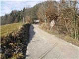 2
2 3
3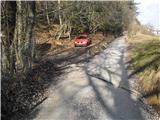 4
4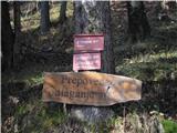 5
5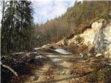 6
6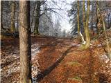 7
7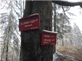 8
8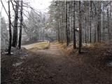 9
9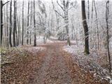 10
10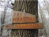 11
11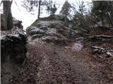 12
12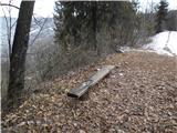 13
13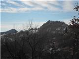 14
14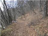 15
15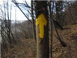 16
16 17
17 18
18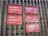 19
19
Discussion about the trip Slavkom dom na Golem brdu - Sveta Katarina (Topol)
|
| potpodnoge20. 09. 2014 |
Hello
On 19.09.2014 my wife and I set off on this path. At the beginning, where the path turns into the forest, there is a posted warning that the mountain path is temporarily closed. Ignoring the notice, we proceeded along the path. In between, where trees were across the path, they were sawn above the path, the path is nicely passable without obstacles or hazards. On the section of the path that is really impassable due to branches on the path, a well-trodden pedestrian detour has been made. What surprised us most was the nice red wooden sign in the direction from Topol towards Golem Brdo, with a short canopy, as seen in picture no. 8, where it said: PATH CLOSED PRIVATE PROPERTY, and at the bottom right corner the signature PD Medvode. I would gladly recommend this pleasant forest mountain path to you, but what if someone fines you, because a prohibition is a prohibition. And then I would be to blame. For clarification, I have already contacted PD Medvode to see what's going on. Of course, the warning about temporary use after ice storm was certainly interim, which it no longer is today. The path is safe for both hikers and occasional walkers. Property is property and it must be respected. Strange that it's the property of a mountaineering association, yet it prohibits its use. Because on all the signposts along the path, there is no additional warning about prohibition of use.
|
|
|
|
| potpodnoge24. 09. 2014 |
Hello
I can happily report that PD Medvode responded quickly (commendable) to my post and the former president of PD provided me with a broader explanation regarding my questions. In short, I won't go into details of the conversation. The path is open to all hikers. They left the sign saying the path is closed due to private property because it wasn't written in the name of PD Medvode, but they removed the signature. I wish all visitors a pleasant path and pleasant feelings, wherever you are.
|
|
|
To post a comment you must log in:
If you do not yet have a username, you must first
register.