Starting point: Šentjur (280 m)
| Latitude/Longitude: | 46,2026°N 15,3932°E |
| |
Walking time: 1 h 30 min
Difficulty: easy marked way
Elevation gain: 370 m
Elevation difference along the route: 380 m
Map:
Recommended equipment (summer):
Recommended equipment (winter):
Views: 74.316
 | 3 people like this post |
Access to starting point:
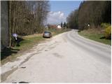
We turn off the Ljubljana - Maribor highway onto the Dramlje exit and continue along the road towards Šentjur. In Šentjur, we continue straight at the traffic light into the underpass under the railway line and follow the road towards Šentrupert. Just after the Šentjur end sign, we notice a parking lot and mountain signs for Resevna on the right side of the road.
Route description:
We continue along the side road, which crosses the river Kozarica over a bridge. The path then takes us past a few houses to a chapel, where the worse road makes a right turn. In the middle of the turn, a marked path branches off to the left uphill to Resevna. This is followed by a transverse ascent through a strip of forest, after which the path brings us back to grassy slopes. The path, which then goes into the forest, leads us after a few minutes to a small settlement, where we step onto the road. The road descends slightly and brings us to an intersection, where we continue to the right uphill. We continue the ascent along a gravel road, which higher up turns into a cart track, and this in turn leads us to a junction of paths, where we continue to the right, along a footpath steeply uphill. After a short steep climb, we step back onto the road, which we follow in the direction of Resevna. After a few dozen steps along the road, the marked footpath directs us to the right uphill. This climb does not last long either, and we are back on the road. We continue past a cross, along a road closed to traffic, which rises moderately and brings us after a few minutes' walk to the mountain hut.
From the hut, we continue along a gentle path, which after a few steps brings us to the top, in the middle of which stands a 20m high observation tower.

Photos:
 1
1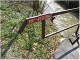 2
2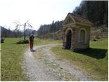 3
3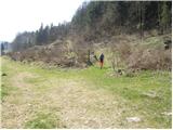 4
4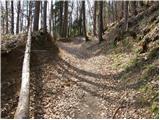 5
5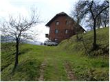 6
6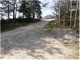 7
7 8
8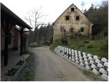 9
9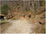 10
10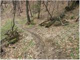 11
11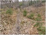 12
12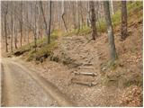 13
13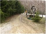 14
14 15
15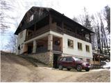 16
16 17
17
Discussion about the trip Šentjur - Resevna
|
| pohodnica532. 04. 2009 |
I'm wondering if anyone knows if the mountain hut at Resevna is open at this time, e.g. this Saturday 4.4.09
|
|
|
|
| pohodnica535. 04. 2009 |
Although I'm a Savinjčanka, today was my first time at Resevna; I never delved into where it is, luckily we have this forum to find something useful, and the path is nicely described; I must say it's a wonderful mountain path (about 1 hour walk), perfectly marked throughout, pleasant hut and benches outside and friendly caretaker; the sto is also very OK and gives wider views; too bad I didn't discover it earlier, I'll gladly return; all who haven't visited, do it soon, you won't regret, especially if sunny like today; friendly friendly  I also greet the nice hikers from Ljutomer and wish them many more pleasant mountain paths and enjoyments; lp I also greet the nice hikers from Ljutomer and wish them many more pleasant mountain paths and enjoyments; lp
|
|
|
|
| jozo25. 04. 2009 |
I used a nice sunny morning for the hike to Resevna. Pleasant walk from Šentjur and friendly hut keeper in the hut, that makes the day even nicer. Tomorrow a bit higher, of course if the weather permits. Greetings to all…
|
|
|
|
| uhan110. 08. 2011 |
I'm interested where to get the stamp during the week, since the hut is open only on holidays and weekends? Thanks
|
|
|
|
| Kokta22. 01. 2012 |
Hi... nice little tour from the mill to the top. Unfortunately no stamp at the tower, because someone cut it off. Greetings to the very friendly hut keeper.
|
|
|
|
| artur3. 03. 2012 |
We were today with the family at Resevna.
No snow anymore, and no mud either.
Friendly caretaker. Apparently open every Saturday and Sunday. Too bad it was foggy, otherwise apparently nice view.
I believe that in summer, when warmer, Šentjurčani like to occupy the benches around the Planinski dom.
Maybe some other time.
|
|
|
|
| nietka19. 02. 2015 |
At the house in picture no. 6 there is now a sign ''private property, passage forbidden''. Does anyone know how to bypass this house or how to get to the road without going through their property? Quite awkward 
|
|
|
|
| bruny22. 02. 2015 |
Private property has probably been there all along where the trail leads. I don't know if they can just prohibit passage like that. They must allow passage at least one meter wide. Maybe someone from PD Šentjur reads this, I assume they manage the trail and can write how things stand!?.
|
|
|
|
| marchy1. 03. 2015 |
We are aware of this problem that arose when we registered Gaberškovo pot with PZS. Intensive discussions are currently underway with the owner of the mentioned parcel and we hope to resolve this problem as soon as possible. On behalf of PD Šentjur, we sincerely apologize to all hikers for the situation and suggest using another path for the ascent to Resevna. In our mountain hut on Resevna, enjoy the culinary delights and the wonderful view of the nearby and distant surroundings from our observation tower. M.R. member of the Board PD Šentjur
|
|
|
|
| Janiel744. 06. 2016 |
Have you arranged anything? It's been 15 months already. Is the path normally passable? Thanks for the info.
|
|
|
|
| slavkoo16. 06. 2016 |
Hello!!? Does no one know the answer? Is the landowner of the plot in the flat areas with the frača or not?
|
|
|
|
| Janiel7416. 06. 2016 |
As the owner of the Planinski dom on Resevna told me, this year the path should be rerouted a bit around there so there are no more complications.
|
|
|
|
| jvali10. 09. 2016 |
Nice path. Excellent štruklji and apple compote, good coffee and friendly hut keeper. Beautiful views from the tower and pleasant company up and down. Specialke are great!
|
|
|
|
| slavkoo8. 06. 2018 |
Janiel 74....The path is indeed routed a bit around unfortunately without markings. The last visible one is a few meters from the starting point at the chapel, then only when you reach the small settlement. Quite awkward, because there are lots of paths in all directions. If I hadn't gone back with a friendly local who was surprised there were no markings, who knows where I'd end up at the base. Otherwise friendly in the hut, nice view from the tower.
|
|
|
|
| bo_zl29. 12. 2021 19:56:46 |
Today on this path. It still holds, no markings, but paths as many as you want. When you reach the farm, you'll see markings on the hayrack. Don't let the path description mislead you. From the farm, go along the slightly ascending road, at the intersection where there are ads for beekeeping, turn left and not right as written in the description. Then follow the road to the intersection where you turn right up the hill. The continuation is no longer difficult, as it is also well marked.
|
|
|
|
| lepenatka6. 04. 2023 19:26:33 |
Still the same situation regarding the markings.
But someone marked the trail at several places with red dots and an arrow.
It helped, although it is not in accordance with the rules and it is routed a bit differently than in the description.
But I made it to the top
|
|
|
|
| Tomaž0026. 05. 2023 15:41:31 |
Are there any orientation problems on this trail, and is parking by the road allowed? Thanks for the answer
|
|
|
|
| garmont26. 05. 2023 19:33:35 |
Park exactly where described and there is space for about 6 cars.
The markers are rarer, but the trail is quite visible. Go boldly.
|
|
|
To post a comment you must log in:
If you do not yet have a username, you must first
register.